Home > Travel > States of India > Umaria District
Umaria District
Umaria district is situated in the north-east portion of the state of Madhya Pradesh. The district of Umaria has extensive forests and is rich in mineral resources.

Share this Article:

Umaria District, Madhya Pradesh Umaria district was formerly the headquarters of the South Rewa District and thereafter the headquarters town of the Bandhavgarh tehsil. This district is situated at a distance of about 69 Kilometres from Shahdol District.

History of Umaria District
Umaria District was a part of Shahdol district in Madhya Pradesh. This district was separated in the year 1998. Rajputs once ruled "Umariya", one of the ancient districts. This family has built the famous and important Lakshmi Narayan Temple on southern bank of Narbada Barman ghat. They also built on the steps of the northern bank of Barman ghat "Kareli" a gateway called the Hathi Darwaza, as their elephants can pass through it. Later the Baghel Rajputs of Rewa (Rewa District) won it from Lodhis, it became the Southern Capital of Rewa Riyasat after some years. Umaria was always a favourite town for many a princes and kings because the dense forests and Royal Bengal Tigers for hunting. The forests of Bandhavgarh were game reserve of Maharaja of Rewa.

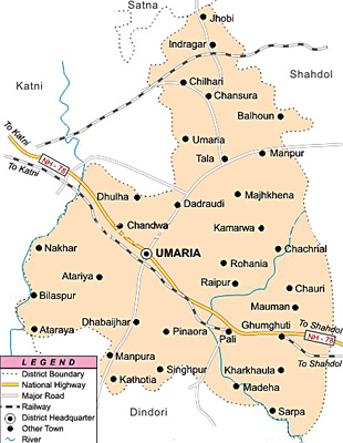
Geography of Umaria District
Umaria district is situated in between the Northeastern parts of Madhya Pradesh. The coordinates of the district of Umaria extends from twenty three degree thirty eight minutes and twenty four degree twenty minutes to the North latitude and eighty degree twenty eight minutes and eighty two degree twelve minutes to the East longitude. Umaria district is spread over an area of four thousand five hundred and forty eight square kilometres. The greatest length of the district of Umaria is about one hundred and fifty kilometres from north to south and the greatest width is about sixty kilometres from east to west.

Demography of Umaria District
According to the population Census in 2011, Umaria District had a population of 643,579 of which male and female were 329,527 and 314,052 respectively. The population of Umaria District constituted 0.89 percent of total population of Madhya Pradesh. The average literacy rate of Umaria was 67.34 percent. The male and female literacy rates were 78.10 and 56.06 respectively. The total literates in Umaria District were 366,414. Out of which the male and female were 217,458 and 148,956 respectively. The density of Umaria district is 158 people per sq. km. Umaria district administers 4,076 square kilometres of areas.

Economy of Umaria District
Umaria District possesses extensive forests and about forty-two percent of the total area is covered by forests only. The district is also rich in minerals. The most important mineral found in this district is coal and as a result, the South Eastern Coalfield Limited in the district is operating eight mines. The famous Bandhavgarh National Park and Sanjay Gandhi Thermal Power Station Mangthar are situated in the district. Major portion of revenue is earned from the tourism.

Tourism of Umaria District
Tourism of Umaria District includes Bandhavgarh fort and Bandhavgarh Tiger Reserve. The fort of Bandhavgarh is a place of considerable archaeological and historical importance. Other tourist attractions in this district are Chandia Khas, Pali Birsinghpur, Umaria Town, and the famous Bandhavgarh Tiger Reserve. The metalled roads connect the town with Katni District, Rewa, Shahdol etc., on which regular buses are available. Umaria district is also a railway station on the Katni-Bilaspur District section of the South-Eastern Railway.


Share this Article:

Related Articles

More Articles in States of India


East Indian States
East Indian States comprises of Bihar, Jharkhand, West Bengal, Odisha and also the Union Territory of Andaman and Nicobar Islands. It defines the cultural heritage, rich historical background and the linguistic unity.
Erode District
Erode District is one of the districts in the state of Tamil Nadu. The district of Erode is having a land-locked area with no sea coast.
Purnia District in Bihar
Purnia District is located in Bihar and extends from River Ganga to Nepal. The district has a rich Hindu history and glorious past.
South Delhi District
South Delhi District is the third largest district of Delhi as far as its area is concerned. South Delhi District is known for its economic, historical, cultural and social significance.
North Indian States
North Indian States formed the cultural and religious unity in spite of having many foreign invasion and the political disturbances from the early era till the British gained supremacy in Indian sub continent.
Kendujhar District
Kendujhar District, spread over an area of 8,240 sq kms, is as varied as the whole of Orissa with waterfalls roaring gorges, mountains and minerals. The manifold expressions of nature in Kendujhar District are considered as unique.
Hooghly district
Hooghly District along the bank of the river Hooghly is one of the principal trading ports of West Bengal.
Districts of South Tamil Nadu
Districts of South Tamil Nadu consist of many tourism destinations like archaeological sites and the history of Pandyas and Cholas. Considering their proximity to the sea, many districts also boast of serene beaches and coastal beauty.
Flora of Arunachal Pradesh
Flora of Arunachal Pradesh includes infinite species and is a subject of great interests for the botanists.
Districts of South Gujarat
Districts of South Gujarat are the epicenter of Jain pilgrimages and the early Hindu kingdoms.
North West States of India
North West States of India consist of three states, which are Rajasthan, Punjab and Haryana. All of them are culturally and traditionally diverse and they have been ruled by different dynasties in historical time.
Geography Of Chittoor District
Geography of Chittoor district is spread along the topography of the land which is divided into two natural divisions; Chittoor has a dry and healthy climate.
Districts of North Rajasthan
District of Northern part of Rajasthan is dotted with ancient forts and medieval villages.
Districts of North Odisha
District of North Odisha has Bengal boundary and shares the same culture. These are reachable if one pays a weekend visit to Digha.
Districts of West Bihar
Districts of West Bihar is comprised of medieval monuments that were built by the different governors of Mughal era.
Districts of South Haryana
Districts of South Haryana consists of many cities of industrial excellence. These districts are dotted with popular tourism destinations.
Medieval History of Assam
Medieval history of Assam narrates the advent and rule of a number of kingdoms in the region. The prominent dynasties of the kingdom left an everlasting imprint on the socio cultural heritage of India.
Geography of Meghalaya
The suitable climate, highland plateaus, rivers and the flora and fauna together forms the geography of Meghalaya.
Districts of Rayalaseema
Districts of Rayalaseema in Andhra Pradesh state has urban population and rural settlements as well.
Districts of South Punjab
Districts of Southern part of Punjab depict medieval history of Punjab and the rise of Sikhs.