Introduction
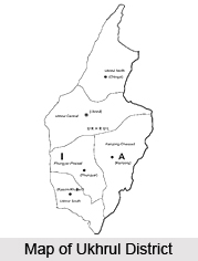 Ukhrul District is one of the nine administrative districts of Manipur. This district of Manipur is bounded by Myanmar in the east, Chandel District in the south, Imphal East and Senapati Districts in the west and Nagaland in the north. The terrain of the district is basically hilly with varying heights of 913 metres to 3114 metres above the mean sea level. Ukhrul is the administrative headquarters of Ukhrul District. Ukhrul, the district headquarter, is 2,020 metres above the mean sea level. Ukhrul District was first marked out as a sub-division in the year 1919. Later it was upgraded to a district in the year 1969 by the Government of India. Administration of Ukhrul District has five sub-divisions. In addition to these administrative units Ukhrul District has four Sub-Deputy Collectors Offices.
Geography of Ukhrul District
Ukhrul District has monsoon type of climate and moderate temperature. The climate of the district is of temperate nature with minimum and maximum degrees of 3 degree Celsius to 33 degree Celsius. The rainy season in the district lasts from May to beginning of October. The hill range that lies in the district headquarter Ukhrul Central sub-division has got very cold climate in winter while other parts of the vast hilly areas of the district have got moderate climate throughout the year. The coldest months of the district are December and January. Geography of Ukhrul District includes some major rivers. Most of the major rivers originate from the crevices and slopes of Shirui Peak. The terrain of the district is rippled with small ranges and striped by few rivers. Thoubal River runs through the Ukhrul North and Ukhrul central sub-divisions. It is the longest and biggest river in the district. Chammu and Chingai rivers are running through Ukhrul North sub-division. These rivers are useful for fishing and irrigation.
 Ukhrul District is gifted with rich flora and fauna. The tropical forests of this district are also the habitat of diverse species of birds and animals. Few minerals are found in the district like Limestone, Chromite and Asbestos. The alluvial soils and some of the residual soils in the valley contain clay.
Culture of Ukhrul District
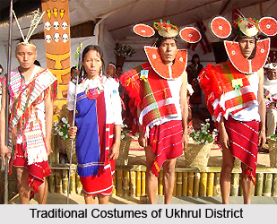 Culture of Ukhrul District is a reflection of the tribal customs and traditions, who have been dwelling in this portion of India since ages. The virgin landscape of Ukhrul district lures visitors who are ardent nature lovers and prefer the tranquil surroundings of spectacular mountains which dot the district.
The Tangkhuls are known to possess an ethnic culture and the name of `Tangkhul` was granted to them by the Meiteis, who are their neighbours. `Luhupas` was the name which was given to the northern Tangkhuls. The residents of Myanmar imparted the name of `Nagas` to these Tangkhuls.
The Nagas or the Tangkhuls sport pierced earlobes, which is an ancient culture of these regional inhabitants of Ukhrul district whose origin is linked to the Mongolian race. They are said to have been associated with a family of Tibeto-Burman, which is actually a sub family of Sino-Tibetan. This implies that their origin is in Tibet and south-western part of China. The upper mountain ranges of Huang Heo and Yangtze Rivers, which are located in the province of Zinjiang, China, are believed to be the most ancient shelters of the Tangkhuls. The Tangkhuls shifted to various directions since they were unable to tolerate the heat of the desert region here. Some of them migrated to China, whole others became tribes of the Tibetao-Burmese area which included other sub tribes of Naga and Tangkhuls. This occurred between 10,000 B.C. and 8000 B.C.
Via Myanmar, the Tangkhuls and other Naga tribes arrived in Arunachal Pradesh, Assam, Nagaland and Manipur. Some of the tribes decided to settle down in Myanmar and were accompanied by Marams, Thangals, Poumeis and Maos. These people constructed megaliths at Makhel to mark their memory of dispersing to different locales from there. The `huison`, `kongsang` and other jewelleries used by the Tangkhuls were composed of cowries, sea shells and conch shells.
Tangkhul tribes were residing in the region of Samshok or Thuangdut in Myanmar by the 2nd century A.D. Following the invasion of Ko-lo-feng, the Tangkhuls started moving away from Samshok. The Shans drove them to the north-western portions of Myanmar soon afterwards. The Tanghkuls, along with numerous other Naga tribes travelled to Myanmar from China. The journey of the Tangkhuls from the nation of China to Myanmar and eventually to India is an account of extreme bravery.
Every Tangkhul village practised an ancient tradition of following numerable rituals. These villages were self dependent in all spheres, except only salt and were governed by self governing units. A hereditary or elected chief, who was assisted by a Council of Elders used to rule the Tangkhul villages. The ruling chief was a commander and a judge too. However, the villages were under constant threats from the organised army which was led by the Meitei king.
Historical evidences indicate that the Tangkhuls existed in the 13th century during the rule of Thawanthaba whose rule continued from 1195 to 1231 A.D. Thawangthaba belonged to the Ningthouja Meitei dynasty. It is said that there existed a trade relation between the Meiteis and Tangkhuls. `Leirungphi` or the `Elephant Cloth`, adorned with intricate animal patterns were worn by the Naga tribes of Manipur and originated in the middle of the 17th century. This special cloth was offered as gift to the allies of the Nagas. `Karaophi` or `Changkhom` is the name of the popular shawl utilized by the Tangkhuls. They were also fond of dancing and their dances involved `Chingkheirol` in the Eastern Indian state of Manipur.
The relationship between Meiteis and the Tangkhuls not only included military conquests and battles, but also involved commerce and trade activities. The Tangkhuls were said to supply cotton to the valley. They were engaged in activities like selling and purchasing in the region of Sanakeithel, which was an important market in Imphal. Manipuri coins termed as `sel` were also employed as a significant means of exchange which was brought about during the rule of Khagemba, who ruled from 1597 till 1652.
Tourism in Ukhrul District
 Tourism in Ukhrul District involves some famous peaks, caves and lakes which boast of the picturesque natural beauty of this Indian district. It is surrounded by Nagaland in the northern side, Senapati District and Imphal East District in its west, Myanmar in the eastern side and Chandel District in its southern side. Mist-covered hills and cascading waterfalls allure innumerable nature-lovers to this district every year.
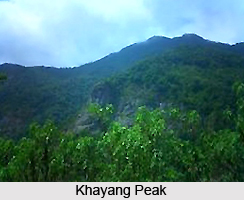
Khayang Peak : Khayang Peak is located at an altitude of nearly 3114 metres from sea level and is renowned for being the highest peak of Ukhrul district.
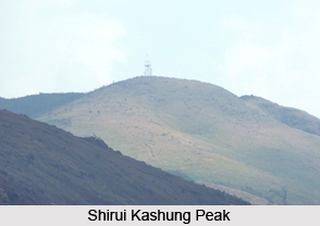
Shirui Kashung Peak : Shirui Peak is situated at an altitude of about 2838 metre from the sea level and this peak is the source of several rivers, which originate from its crevices. During the months of May and June, Siroi lily blossoms adorn this hilltop.
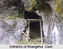
Khangkhui Cave : Khangkhui Cave is a spectacular limestone cave based in the district of Ukhrul. As per the regional folk tales, the northern hall of this cave served as the royal bedroom of the `Devil King` while the grand hall is believed to be his `darbar` hall. Local villages are said to have sought refuge in this cave during World War II.
 Shirui : Located at a distance of nearly 39 km from Ukhrul and 90 km from Imphal, Shirui, it consists of the blossoms of Siroy Lily flower, which is a world-renowned species of flora. This beautiful flower is regionally known as `Kashong Timrawon`. The Kashong Timrawon is said to be a protective spirit which dwells on the Shirui Peak, according to the local folklore. Shirui is visited by innumerable tourists and scientists from across the globe to view this flower.
Khangkhui Mangsor Cave : The cave of Khangkhui Mangsor is based about 15 km from the eastern portion of Ukhrul and it is within the vicinity of the village of Kangkhul. Five tunnels and two giant chambers are present inside this cave, which is linked to numerable regional legends. According to one such legendary tale, the Mangsor deity is a protective deity who is compassionate and quite romantic. He is believed to possess two wives, one of whom belonged to Shirui Peak and the other who hailed from Koubru Hills of Senapati District. The first wife had no children and was granted a grand chamber inside this cave while the second wife was given smaller but more number of rooms, which gives an idea that she bore children.
Kachouphung Lake : This lake is located at a distance of nearly 7 km from the south-eastern portion of Khayang Falls, on the slopes of Achuwa Magi Hills, which is surrounded by some knolls. The total area occupied by Kachouphung Lake is nine acres. Colourful fishes and carp are existent in this lake, which offer ample opportunities for the industry of pisciculture. The shape of the lake is similar to the map of India. During the monsoons, the size of this lake expands. Sometimes, the water of Nily River is drained into this river to increase the size of this lake.
Ango Ching : Ango Ching is situated at a distance of nearly 150 square kilometres and is surrounded by Chamu River in the western side Kachouphung in the northern side, Myanmar in the eastern part and Chatric in the southern part. The region of Ango Ching is amongst the virgin terrain which is enriched with a rich variety of wildlife and vegetation. Leopard, tigers, elephants, black bear, hornbills, peacock tragopan and sambhars are amongst the animals found here.