
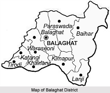
 Balaghat District in Madhya Pradesh looks like a flying bird and is situated in southern part of Jabalpur division. It occupies the southeastern region of the Satpura Mountain Range and Upper Wainganga River Valley.
Balaghat District
Balaghat District in Madhya Pradesh was formed during the years 1967-1973. Balaghat District in the map of Madhya Pradesh looks like a flying bird.
Introduction
Balaghat District in Madhya Pradesh looks like a flying bird and is situated in southern part of Jabalpur division. It occupies the southeastern region of the Satpura Mountain Range and Upper Wainganga River Valley.History of Balaghat District
Balaghat District was constituted during the years 1967-73 by amalgamation of parts of the Bhandara District, Mandla District and Seoni districts. The headquarter of the district was originally called "Burha" or "Boora". Later, however, this name fell into disuse and was replaced by "Balaghat", which was originally the name of the district only. The Wainganga River is the most important river of the district.
Geography of Balaghat District
Balaghat district of Madhya Pradesh spans over a degree from 21.19 degrees to 22.24 degrees North and 79.31 degrees to 81.3 degrees east. The total area of the district is 9245 square kilometres. The Wainganga River separates the district from Seoni while the Bawanthadi River and Bagh River define the inter-state boundary.
The District is very rich in forest wealth. Around 52% of the area is covered with forest. Teak, Sal, Bamboo and Saja are the main trees. Almost 25 years ago, the district was nicknamed as "Hunters Paradise". District is still proud of its varied fauna consisting of Royal Bengal Tiger, Leopard, Bear, Nilgai, deer & bison on one side and birds like Peacock, Red Bulbul and Koyal on the other.
Balaghat district occupies a pride place on the mineral map of India. About 80 percent of the Manganese production of the country comes from Balaghat. The recent discovery of Copper deposit at Malajkhand is regarded as the largest in the country. Over and above this Bauxite, Kyanite and Limestone are the other main minerals of the district.
The District is very rich in forest wealth. Around 52% of the area is covered with forest. Teak, Sal, Bamboo and Saja are the main trees. Almost 25 years ago, the district was nicknamed as "Hunters Paradise". District is still proud of its varied fauna consisting of Royal Bengal Tiger, Leopard, Bear, Nilgai, deer & bison on one side and birds like Peacock, Red Bulbul and Koyal on the other.
Balaghat district occupies a pride place on the mineral map of India. About 80 percent of the Manganese production of the country comes from Balaghat. The recent discovery of Copper deposit at Malajkhand is regarded as the largest in the country. Over and above this Bauxite, Kyanite and Limestone are the other main minerals of the district.
Demography of Balaghat District
In 2011, Population Census revealed that Balaghat had population of 1,701,156 of which male and female were 841,794 and 859,362 respectively. Balaghat District population constituted 2.34 percent of total population of Madhya Pradesh. The average literacy rate of Balaghat in 2011 was 78.29 compared to 68.72 of 2001.The male and female literacy was 87.13 and 69.71 respectively.
Tourism of Balaghat District
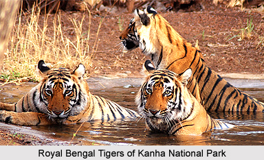 Tourism of Balaghat District is popular among the people of India and the people of foreign countries. Balaghat, one of the districts of Madhya Pradesh, has some of the popular tourist places and as a result, many people throng the region of Balaghat throughout the year. Some of the well-known tourist places of Balaghat District are Kanha National Park (Kanha Tiger Reserve) the Lanji Temple and the fort, Nahlesara Dam, Dhuti Dam, Rampaily Temple, Hatta Bawali and Gangul Para Tank and Waterfall.
Kanha National Park
Kanha National Park falls in the Balaghat and Mandla districts. It is located in the "Maikal" ranges of the Satpura Mountain Range. The Park is internationally renowned for its rich floral and faunal attributes.
The National Park has distinguished itself in saving, the endangered hard ground barasingha (cervus, duvaceli, branderi) from extinction and has the unique distinction of harbouring the last world population of this dear species. Barasingha is State Animal of Madhya Pradesh.
Lanji Temple or Fort
The Fort is located at Lanji Tehsil of Balaghat. The Temple and its Statutes art are of Khajuraho Temples` style. The Lanji Fort is also related with Gond Dynasty. There are so many temples within Fort with lot of Statutes like Lord Shiva, Mahamaya, Lanjkaidevi etc.
Rampaily Temple
Rampaily Temple is a historical place located 30 Kilometers away from District head quarter. The temple is built on the bank of Chandan River, in which Lord Rama, Lord Hanuman and Balanji`s big statutes are there.
Nahlesara Dam
Nahlesara Dam is built on Chandan River. Its length is 1.5 kilometres and it is quite old Dam, it was built some where around 1960-1965. It is 58 kilometers away from district headquarter Balaghat. The Dam is used for irrigation purpose. Behind the Dam about one kilometre, away one temple Amma Mai is there which is also famous.
Hatta Bawali
The village Hatta is located about 30 Km away from the district headquarter. The village Hatta is famous for its historical history. At the time of British government, Hatta was centre of a powerful Zamindari system. Here one Bawali and old temple is situated. It was built in 17th Century.
Dhuti Dam
The Dhuti Dam is built on Wainganga River and it is around 65 km. away from Balaghat near Lamta. The dam is quite oldest; it was constructed during year 1911-23. The Dam height is 26.6 ft, its length is 4040 ft, and width 881ft. The maximum water level of Dam is 1077.5 ft. This dam mainly serves the irrigation purpose of the villages.
Gangulpara Tank and Water Fall
From district headquarter Balaghat around 14 km. away on Baihar road the Gangulpara Tank and Waterfall is located. The natural beauty surrounding Tank and Waterfall looks nice. People at Balaghat used to go there for picnic. The Tank stores the water of Ghysri Nala and it is used for irrigation purpose.
Balaghat district is well connected by buses, directly with important places such as Bhopal, Nagpur, Gondia, Jabalpur, Raipur etc. The District Headquarter is situated on Narrow gauge line of Jabalpur-Balaghat and Broad-gauge line of Balaghat-Gondia section of South-Eastern Railway. The nearest Airport is at Nagpur.
Recently updated articles in States of India

Bandare Waterfalls, Meghalaya
Bandare Waterfalls in South Garo Hills, Meghalaya, is a secluded natural attraction surrounded by dense subtropical forests and rugged mountain terrai...

History of Thissur District
Early History of Thissur District explains flourishing of the port cities. Now these port cities are transformed into archaeological sites.

Tippi Orchid Research Centre, Arunachal Pradesh
Tippi Orchid Research Centre in Arunachal Pradesh is renowned for its rich collection of exotic and endangered orchids. Surrounded by lush rainforest...

Tourism in Nashik District
Pilgrimage tourism in Nashik district involves visiting the various places of Hindu and Jain worship located here. Some of the holiest sites for Hind...

Mangadu, Kerala
Mangadu in Kerala’s Kollam district is a significant megalithic site known for its urn burials, cist burials, menhirs, and stone circles. Excavations...
Related articles in States of India

East Indian States
East Indian States comprises of Bihar, Jharkhand, West Bengal, Odisha and also the Union Territory of Andaman and Nicobar Islands. It defines the cult...

Purnia District in Bihar
Purnia District is located in Bihar and extends from River Ganga to Nepal. The district has a rich Hindu history and glorious past.

Hooghly district
Hooghly District along the bank of the river Hooghly is one of the principal trading ports of West Bengal.

Geography Of Chittoor District
Geography of Chittoor district is spread along the topography of the land which is divided into two natural divisions; Chittoor has a dry and healthy...

Districts of West Bihar
Districts of West Bihar is comprised of medieval monuments that were built by the different governors of Mughal era.