
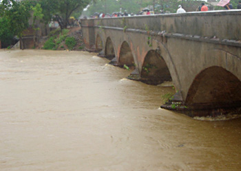
 Katni district in the state of Madhya Pradesh is located in the north-eastern part of Madhya Pradesh. It forms the northern district of Jabalpur commissionerate division. Mudwara was the biggest (area wise) tehsil of Jabalpur before Katni came as a district in 1998. The district extends from 23 degrees 37 minutes north to 24 degrees 80 minutes north and from 79 degrees 57 minutes east to 80 degrees 58 minutes east.
Katni District
Katni District of Madhya Pradesh is more or less in the shape of an oval. The district of Katni was formed in the year 1998.
Introduction
Katni district in the state of Madhya Pradesh is located in the north-eastern part of Madhya Pradesh. It forms the northern district of Jabalpur commissionerate division. Mudwara was the biggest (area wise) tehsil of Jabalpur before Katni came as a district in 1998. The district extends from 23 degrees 37 minutes north to 24 degrees 80 minutes north and from 79 degrees 57 minutes east to 80 degrees 58 minutes east.Geography of Katni District
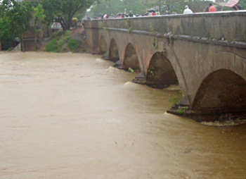 Geography of Katni district covers an area of 4949.59 square kilometers. The district of Katni is situated in the Northeastern parts of the state of Madhya Pradesh in India and also forms the northern district of Jabalpur commissionerate division. Mudwara was the biggest (area-wise) tahsil of Jabalpur before Katni became a district in the year 1998. The Katni district is located between twenty three degree thirty seven minutes and twenty four degree eighty minutes to the North latitude and seventy nine degree fifty seven minutes and eighty degree fifty eight minutes to the East longitude. This district in the Madhya Pradesh state is placed three hundred and ninety two meters above sea level.
River Katni, River Chhoti Mahanadi and River Umdar are the three major rivers in the Katni district and the name Katni of Mudwara is given after the Katni River, which is two kilometers away from Mudwara. The shape of the district of Katni is roughly oval. The district enjoys an average climatic condition.
The major crops grown in this district are paddy, wheat, gram and pulses. In cash crops, mainly vegetables are grown and sent to market of Satna District and also to Umaria. There is a good market of cereals and other agro-based product in Katni. Krashi Upaz Mandi Katni has been given the status of `A` class mandi in India. The area under cultivation in this district is thirty four thousand five hundred and ninety three hectares in the year 2001, and total forest area consisted of seventy one thousand one hundred and fifty five hectares. Private land in this district is 279020 hectares and Government land comprises of 214072 hectares.
Administration of Katni District
Since the beginning of 20th century Mudwara (Katni) has been given the status of town. Development work of the town has been started along with the British rule. Government MP has set up a district administration in 1998 after upgrading Tehsil Katni to District. It was a major task for the district administration to bring up Katni as the developed district. Katni is progressing day by day and giving facilities to the citizen of the district.
Education of Katni District
In the field of education Katni is frontrunner. There has been sudden enhancement in higher education also. A number of new professional colleges have been set up which are providing Masters Degree in technical fields also.
Economy of Katni District
Katni is an ancient city in which many industries are located in whole district. As minerals are found in large part of Katni so the industries of mineral based are growing rapidly besides these pulses mills are very much found in Katni. All these have made good position of Katni in commerce and industry field. There is also a good market of cereals and other agro-based products in Katni. Katni District also has a good cloth market.
Altogether it can be said that Katni is a commercial centre which enjoys a strategic location because it enjoys the advantage of national highway and train routes. In fact Katni District in the present age is so commercially advanced that it enjoys all the luxuries of modern communication.
Altogether it can be said that Katni is a commercial centre which enjoys a strategic location because it enjoys the advantage of national highway and train routes. In fact Katni District in the present age is so commercially advanced that it enjoys all the luxuries of modern communication.
Tourism of Katni District
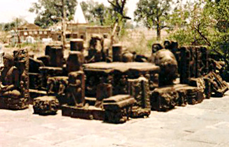 As per as tourism is concerned in the district of Katni it more or less has historical importance. Katni District which has grown commercially in the present age is also known for its number of tourist destinations. Some of the prominent tourist destinations of Katni District are Bahoriband, Tigavan, Vijaraghavgarh, Roopnath, Bilhary and Jhinjhari.
Bahoriband : In Bahoriband there are many monuments. There is a statue of Jain Teerthankar Shantinath which is12 feet high where some scripture of 12th century is written in the lower part of the statue telling about Maha samantadhipati Golhneshwar Rathore who was the ruler under Kalchuri`s kings Gayakarndev.
There are many statues in the north of the village. Near the reservoir a stone has been found in which 10 incarnations of Lord Vishnu has been painted. There are also many statues of Narayan Shaishayani (bed) and the sun-god (Lord Surya). At the same time there is also a cemetery of Oliya Peeran Peer and a village is associated with it. Now a day Bahoriband has gained more importance and fame after a stone park has been set up.
Tigavan : Earlier Tigavan was a part of Bahoriband. In Tigavan there is a temple which is around 1500 years old. It is a flat ceiling temple. There is a statue of Lord Narsing in other side of wall and there are statues of Jain Treethankars.
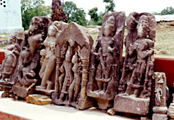 The temple dates back to the Gupta dynasties. There were more than 30 temples in Tigavan, now only the remains are found.
Vijaraghavgarh : Vijaraghavgarh is a historical fort located 33 kilometres away from Katni District. The place is 350 m above sea level. The prince Prayagdas had constructed a temple of lord Vijayraghav and the fort was named as Vijayraghavgarh. In fact the fort is the most beautiful fort that is present in Katni District.
Roopnath : Roopnath is a pilgrimage place 3 kilometres from Bahoriband. There is Panchlingi(five lingam) statue of Lord Shiva and is called as Roopnath. It is situated in the corner of Camore Mountain. There are three Kunds (tanks) one above another. The lowest one is called Sita Kund the one above is known as Laxman Kund and the topmost is know as Ram kund.
Bilhary : The old name of Bilhary was Pahupavti/Pushpawati Nagri. In the region there were so many temples but today the only remaining is the Varah temple of Lord Varah (Vishnu). There is one more temple of Lord Shiva around one kilometre from Bilhari it is also know as fort of Kamakandla.
Jhinjhari : The rocks which are present in the Jabalpur Road are big and coloured. It is believed that they are all of prehistoric time and it is believed that it was the residence for early human. The animals which were found in the rock structures were a Cow, Bull, Deer, Dog, Goat, Pork, Hippopotamus etc. Hippopotamus is believed to be present even in the ancient time. Except this animal there are paintings available about fighting tools and man and woman, tree, flower. These paintings are believed to date back to10000 BC to 4000BC. Some of the pictures are also of middle age that is from 700 BC to 200 BC.
Recently updated articles in States of India

Bandare Waterfalls, Meghalaya
Bandare Waterfalls in South Garo Hills, Meghalaya, is a secluded natural attraction surrounded by dense subtropical forests and rugged mountain terrai...

History of Thissur District
Early History of Thissur District explains flourishing of the port cities. Now these port cities are transformed into archaeological sites.

Tippi Orchid Research Centre, Arunachal Pradesh
Tippi Orchid Research Centre in Arunachal Pradesh is renowned for its rich collection of exotic and endangered orchids. Surrounded by lush rainforest...

Tourism in Nashik District
Pilgrimage tourism in Nashik district involves visiting the various places of Hindu and Jain worship located here. Some of the holiest sites for Hind...

Mangadu, Kerala
Mangadu in Kerala’s Kollam district is a significant megalithic site known for its urn burials, cist burials, menhirs, and stone circles. Excavations...
Related articles in States of India

East Indian States
East Indian States comprises of Bihar, Jharkhand, West Bengal, Odisha and also the Union Territory of Andaman and Nicobar Islands. It defines the cult...

Purnia District in Bihar
Purnia District is located in Bihar and extends from River Ganga to Nepal. The district has a rich Hindu history and glorious past.

Hooghly district
Hooghly District along the bank of the river Hooghly is one of the principal trading ports of West Bengal.

Geography Of Chittoor District
Geography of Chittoor district is spread along the topography of the land which is divided into two natural divisions; Chittoor has a dry and healthy...

Districts of West Bihar
Districts of West Bihar is comprised of medieval monuments that were built by the different governors of Mughal era.