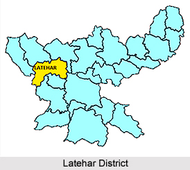
 Latehar district has been created on 4th April 2001. Earlier it was a subdivision of old Palamau district of Jharkhand State. Latehar district is situated between 84degree and 31 minutes. East latitude 23 deg. 44.4 sec north latitude. The geographical area of the district is 3651.59 square kilometers. There are 7 Development Blocks, namely Latehar, Chandwa, Balumath, Manika, Barwadih, Garu and Mahuadar.
The administration of the Latehar District is shouldered by of the Deputy Commissioner. He is the head of the district administration and is ex-officio chairman of various societies and agencies that are involved in the development of the district. Deputy Commissioner is also the District Programme Coordinator under NREGA. Various Societies and governmental agencies that are in the direct control of the Deputy Commissioner are D.R.D.A., D.U.D.A., MESO, Centrally Sponsored Social sector, Welfare schemes etc.
The Deputy Development Commissioner is the ex-officio Managing Director of D.R.D.A. as well as Chief Executive officer. There are seven blocks in the district. At the block level Block Development officers are involved in development works of the respective blocks, there are supervisory level officials & Panchayat Sevaks and Jansewaks at the panchayat level.
A MESO Officer is also appointed to look after the district and to take care about various development schemes for the Tribals. All these line departments though work under their respective controlling officer of the department, but they are under indirect control of Deputy Commissioner.
Demography of Latehar District
According to the Population Cenus report published in the year 2011, Latehar District had population of 725,673 of which male and female were 369,534 and 356,139 respectively. The population of Latehar District constituted 2.20 percent of total population of Jharkhand. The population density of Latehar district for 2011 is 200 people per sq. km. The average literacy rate of Latehar in 2011 was 61.23 percent compared to 40.69 of 2001. If things are looked out at gender wise, male and female literacy rates were 71.80 percent and 50.26 percent respectively. The total literates in Latehar District were 363,059 of which male and female were 216,794 and 146,258 respectively.
Economy of Latehar District
The economy of Latehar District can be sub divided into various segments. These segments have been briefly discussed below:
(a) Agriculture: - A large number of people are engaged in agricultural activities. Cultivation of paddy, maize, cereals, wheat, oil seeds etc. are common. The people are either working as agricultural labourers or cultivators. Kharif and Rabi are the main agricultural seasons. Karma festival is celebrated for good production of crops.
(b) Forest: - Out of total geographical area of 4211-2508 sq. k.m., forest area covers about 2245 sq. k.m. The tribal economy revolves around using forest products, by products and minor products. Kendu leaves, Bamboo and its manufactured products, Mahua, fruits, leaves that is used is the making of dona, pattal, lac etc. play an important role in the economic activity of the people. People also hunt animals for food and `Jani shikar` festival is related to this hunting habit.
(c) Mines and Minerals: - The geological reports say that the district is very rich in various mineral deposits. There is abundance of deposit of Coal, Bauxite, Laterite, Dolomite, and Graphite etc. The excavation and exploration of these minerals have provided job opportunities to the inhabitants of this hinterland to some extent because these minerals have not been fully explored at large scale and there are no mineral based industries in the district.
(d) Animal Husbandry: -The quality of livestock is very poor. Cow, goats etc. are of local variety and the average milk yield is very less.
(e) Trade and Commerce: - In place of old landlords, various banks are operating their branches is the district but it is a matter of fact that most of the villages are so scattered that the system of primary trade in the hands of vyaparis and village sahukars still continues. Paddy thrashing, dona pattal making, bamboo basket making, selling of mahua flowers. Lacs, kendu leaves and other minor forest produces are main components of trading activities. In the absence of major industries and employment opportunities, the options of economic development are limited. Animal husbandry, piggery and fisheries etc. have good potential, but this sector has still remained unexplored.
Tourism in Latehar District
There are many tourist places in Latehar that are visited by many tourists. Betla National Park, Lodh fall in Mahuadanr, Mahudanr Wolf Sanctuary, Kanti fall in Chandwa, Kutku rapids in Barwadih, Kechki.-confluence of Orenga and Koel in Barwadih, New and old forts of Palamau in Barwadih, Netarhat plateau in Mahuadanr are few of the beautiful spots located in Latehar.


