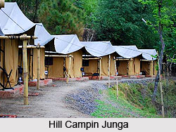
 Junga is a tehsil in the Shimla district of Himachal Pradesh. This town in Shimla attracts a large number of tourists, while visiting Shimla. Junga has many trekking camps where the adventure lovers can see the landscape beauty and the trekking routes which are quite affordable to the pocket friendly tourists. This beauty of nature can be seen from the foothills of Junga Valley. Junga is very near to Chail of Himachal Pradesh and the Shilmla town.
Location of Junga
Junga is located at 31.02 degree north to 77.18 degree east. Junga has an average elevation of 1,582 metres (5,190 feet). It is located 26 kilometres away from the city of Shimla. It is about 18 kilometres from Chail and 28 kilometres from the skiing destination Kufri.
Geography of Junga
Junga is surrounded by green hills with snow-capped mountains and has a forest cover of kail, deodar, pine, cheel, ban and other trees. The temperature range of Junga is not very high, and the maximum temperature rarely crosses 25 degree Celsius during summers. The winters of Junga are cold due to the chilly winds from the Himalayan Mountain Range.
Tourism in Junga
Junga is known for the palace of erstwhile Princely State of Junga. The estate of Junga, also known as Keonthal estate, was formed before 1800 AD. There one can find the architectural remaining of the colonial history of British East India Company and the British Government of India. Towards the north of Junga lies the snow-covered high ranges.
Visiting Information
Junga is well-connected by road and rail. The National Highway NH 22 connects Kandaghat to the nearest big city of Chandigarh. Junga is located at a distance of 22 km from Kandaghat. The total driving time from Delhi to Junga is approximately 6.5 hours. The nearest rail head is Kandaghat. The Kalka-Shimla Railway, a narrow gauge track, connects Kandaghat with Kalka. The Kalka-Shimla Railway is listed in the Guinness Book of Records for the steepest rise in altitude in a distance of 96 km. Kalka, the rail terminus in the plains, has daily departures to major Indian cities. The flights from the airport at Jubbarhatti 35 kilometres away connect Shimla to Delhi.


