About Lalitpur district
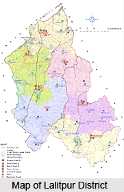
Lalitpur district is a prominent district of the Indian state of Uttar Pradesh. The district is a part of the Bundelkhand region with the district headquarters in the city of Lalitpur. It is encircled by the Tikamgarh district in the east, Sagar district in the south, and Ashoknagar and Shivpuri districts in the west and the Jhansi district in the north. The town is located between 24 degree 11 minutes and 25 degree 14 minutes north latitude and 78 degrees and 10 minutes and 79 degrees and 0 minutes east longitude.
The district forms a part of the hill country of Bundelkhand. The southern part of the district consists of small hills and through the valleys flow the sparkling rivers over the shelves of granite and quartz. The northern and western part of the district is bounded by the Betwa River and the Jamni River, a tributary of the Betwa forms the eastern part of the district. The southeastern part of the district is bounded by the Dhasan River.
The Lalitpur district was founded in the 17th century by a Bundela Rajput who was a descendant of Rudra Pratap of Orchha.
At that time it was a part of the state of Chanderi. In 1844, during the British rule in India the former state of Chanderi became the Chanderi district. From 1891 to 1974 Lalitpur district was a part of Jhansi district. It became a separate district in 1974. The district is divided into three tehsils Lalitpur, Mehroni and Talbehat. The four prominent towns of the district are Lalitpur, Mehroni, Talbehat and Pali along with seven hundred and fifty four villages. Sprawling over an area of 5,039 sq.km. the district is in the shape of a heart.
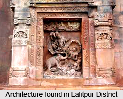
The district has a subtropical climate with hot dry summers and cold winters. The economy of the district is predominantly agrarian. Lush green fields and glittering rivers characterize the landscape of the district. The calmness of the district is really enchanting which attracts a lot of tourists. The prime attractions in the district are Deogarh, Ranchourji Neelkantheshwar Trimurti (Pali), Andela, Matatila Dam, Seeronkhurd, Dudhai, Dewa Mata, and BandarGurha.
History of Lalitpur District
History of Lalitpur District says that it was formerly a part of the state of Chanderi, founded in 17th century by Bundela Rajputs who descended from Rudra Pratap of Orchha. Chanderi, along with most of Bundelkhand, came under Maratha dominion in the 18th century. Daulat Rao Sindhia of neighbouring Gwalior state annexed Chanderi state in 1811. In 1844, the former state of Chanderi was surrendered to the British, and it became the Chanderi District of British India, with Lalitpur town as the district headquarters. Further, the history of Lalitpur District states that the British lost the district in the Indian Rebellion of 1857, and it was not re-conquered until late 1858. In 1861, some portion of the district, including Chanderi, was returned to Gwalior, and the rest was renamed as Lalitpur District . Lalitpur District was made part of Jhansi District from 1891 to 1974.
Further, as per the historical accounts, Lalitpur was carved out as a district in the year 1974. Lalitpur is joined to Jhansi District of Uttar Pradesh by a narrow corridor to the northeast, but is otherwise almost completely surrounded by Madhya Pradesh; to the east there is Tikamgarh District, to the south Sagar District, and to the west Ashoknagar District and Shivpuri District. Lalitpur, Jalaun and Jhansi districts form Jhansi Division. Jhansi Division is one of 17 divisions of Uttar Pradesh in northern India. It includes Jhansi, Jalaun, and Lalitpur districts. The city of Jhansi is the administrative centre. The division is part of the historic Bundelkhand region, which includes a portion of southern Uttar Pradesh and extends into the neighbouring state of Madhya Pradesh.
Geography of Lalitpur District
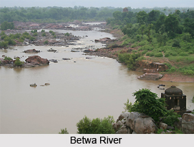
Geography of Lalitpur District forms a portion of the hill country of Bundelkhand. It is sloping down from the outliers of the Vindhya Range on the south to the tributaries of the Yamuna River on the north. Extreme south of the district is composed of parallel rows of long and narrow-ridged hills. Through the intervening valleys the rivers flow down over ledges of granite or quartz. North of the hilly region, the granite chains gradually turn into clusters of smaller hills.
The climate of Lalitpur District is the Central India type sub-tropical and may be characterized by a very hot dry summer and cold winter. Like other districts of the Bundelkhand region, this also shows four distinct seasons. Summer season from March to mid-June, Monsoon from mid-June to September, post-monsoonal transition between October and November while the winter months are December to February. The day temperature is the highest during May and June which falls steeply with the onset of monsoon in mid-June or July. It rises again around September and goes a little higher during October. Then with the beginning of winter, the temperature falls and becomes minimal in January.
Betwa River forms the northern and western boundary of the geography of Lalitpur District, and most of the district lies within its watershed. Jamni River, a tributary of the Betwa, forms the eastern boundary of the district. Dhasan River forms the district`s south-eastern boundary, and the south-eastern portion of the district lies within its watershed. Topography of Lalitpur District is generally rocky. The highest ground is in the extreme south with scraps of the Vindhya plateau, running from the Betwa in south-easterly direction and gradually breaking up into a confined mass of hills, parts of which approach a height of 650 metres above mean sea level. The north of the scrap, undulating plain of Regur soil interrupted with scattered hills and scoured by numerous drainage channels, stretches north beyond the town of Lalitpur and gradually becomes rockier. Low red hills of granite rock appear with long ridges running from south- west to north- west.
Most of the area of Lalitpur District is drained by river Jamni and its tributaries which form its eastern boundary, separating it from Tikamgarh district. River Betwa forms the western and northern boundary and drains the western part of the district. The south eastern part is partly drained by Dhasan River. In general the slope is towards the north. The hills in the south generally occur in small groups or in continuous narrow chain running parallel to each other from north-east to south-west, the ridges being mostly bare and sharp. The slopes are still comparatively more covered with scrub jungles. The plateau is intersected by wide valleys particularly in the south west. Mining has affected the whole area considerably. From the base of the plateau to the town of Lalitpur stretches a black soil plain which is dissected by a number of seasonal rivulets and is characterized by an undulating topography.
The soils of Lalitpur District are also representative of typical Bundelkhand varieties of soils. The soils here have developed from Vindhya ranges of rocks which in this area are formed of gneiss, granite, quartzite and at times sandstone, limestone and slate. The soils of the district are divided into two broader categories - Black Soil and Red Soil groups. A strip of alluvial soil is also found in the western part of Lalitpur District.
Dams in Lalitpur District
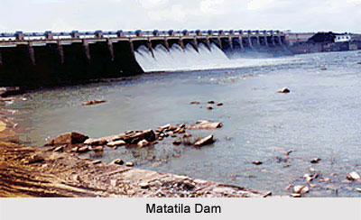
The dams in Lalitpur district of Uttar Pradesh are quite popular ones in the state for their function of power generation and storing irrigational water. Matatila Dam was built during 1952-1964 on Betwa River in Lalitpur District with a length of about 6.30 km and height of about 33.53 meters. This dam encompasses an area of almost 20,720 Sq.km. and has a storage capacity of 1132.68 M.c.m. Jamni Dam was constructed during 1962-1973 on Jamni River. The dam is 6.40 km long and 19.18 meters high. The Jamni Dam has an area of 414 Sq.km with storage capacity 92.89 M.c.m.
Rohini Dam, constructed during 1976-1984 on Rohini River has a length of 1.65km and is 15.50 meters high. The area of this dam is around 44 Sq.km and the storage capacity is 12.12 M.c.m. The Shahzad Dam was constructed during 1973-1992 on Shahzad River for a length of about 4.16 km and height 18.00 meters. The area of this dam is almost 514 Sq.km. with the storage capacity 130.00 M.c.m. Govind Sagar Dam was constructed during 1947-1953 on Shahzad River and is 3.60 km long. The dam is 18.29 meters high with an area of 368 Sq.km and storage capacity 96.8 M.c.m. Sajnam Dam was constructed during 1977-1990 on Sajnam River. The dam features 5.15 km length, 18.78 meters height, 290 Sq.km. area and 83.50 M.c.m storage capacity.