 Geography of West Khasi Hills District is divided into four broad units - western sector, southern sector, northern sector and central sector. The western sector with dense forests with an elevation of 600 to 900 metres is bordering the Garo Hills. In the southern sector, especially the south-eastern part, the hills slope rather abruptly to an elevation of about 150 metres, close to the plains of Bangladesh. In the northern sector, there are a series of hills and ranges which gradually slope down to an altitude of about 150 metres till they reach the plains of Assam. In the central sector, the hill ranges run parallel from east to west forming the highest part of West Khasi Hills District with an average altitude of around 1400 metres.
Geography of West Khasi Hills District is also characterized with a moderate climate although it differs as per the different zones. Like for instance, the climate is mildly tropical in the northern and southern foothills, while in the central upland zone, the climate is temperate and places at medium altitude in the northern, western and southern parts of the district, experience sub-tropical climate. West Khasi Hills District is influenced by south-west monsoon and rainfall is assured during summer, but it differs greatly in intensity from area to area within the district. The average rainfall of this district of Meghalaya ranges from 1200 mm to 3000 mm per annum.
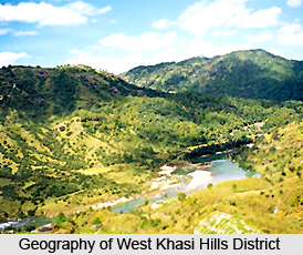
Topographical features of West Khasi Hills District include a significant hill range that is the Mawthadraishan range, which runs from east to west. The other major hills are U Mawleng in the Lyngngam area located between Nongiawnaw and Snaram and the Mawhiang rock at Mawkyllei near Pariong. River systems also form a part of the geography of West Khasi Hills District. There are two important river systems in the district, the Kynshi and the Khri, with a number of tributaries. Kynshi is the bigger one and it rises in the southern slopes of Marpna Peak near Mawmaram village (about 10 kms from Mairang on the way to Shillong). It follows a westerly course for a considerable distance then takes a sharp bend to the east and enters the plains of Bangladesh at Ranikor. The Khri River rises near Kyllang rock and flows northwards and is joined by Khri Synnia River before it enters the plains of Assam. Other important rivers that constitute the drainage system of West Khasi Hills District are Umngi, Wahblei, Rilang, Riangdo, Tyrsung, Ryndi, Rwiang, Umit Synthi and Btit.
West Khasi Hills District is blessed with a rich heritage of flora comprising Khasi pines in the higher altitude areas and Teak, Sal, Titachap, Gamari and Makri Sal in the lower elevation zones. Orchids and pitcher plants are also found in the district. However, with the passage of time, owing to the deforestation process most of the species have been depleted. Fauna of West Khasi Hills District includes elephants, apes, monkeys, deer, tigers, wild boars, bears, leopards and many others. However, due to poaching and deforestation, number of wild animals has depleted to a huge extent. Further, West Khasi Hills District is very rich in mineral resources, but most of the minerals are under investigation. Important minerals in the district are Sillimanite, coal, limestone and Uranium. West Khasi Hills District is also endowed with vast reserves of sand and stones.


