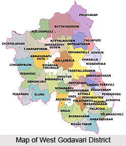
 West Godavari is one of the twenty three districts of the state of Andhra Pradesh. Eluru is the district head quarter of West Godavari district and the district is in the delta region of River Krishna and River Godavari. The district encompasses an area of 7742 square kilometres.
West Godavari District
West Godavari is one of the districts of Andhra Pradesh situated in the coastal plains. It is known as the granary of India.
Introduction
West Godavari is one of the twenty three districts of the state of Andhra Pradesh. Eluru is the district head quarter of West Godavari district and the district is in the delta region of River Krishna and River Godavari. The district encompasses an area of 7742 square kilometres.Geography Of West Godavari District
West Godavari District, as its name indicates, is a part of the Godavari Delta in Andhra Pradesh. It lies between 16 degrees 15 min-17 degrees 30 min northern latitudes and 80 degrees 55 min and 81 degrees 55 min eastern longitudes. It is surrounded by Khammam District on the north, Krishna District and the Bay of Bengal on the south and on the east by river Godavari and Krishna District on the West. The District occupies an area of 7742 sq. kms with density of population of 454 per sq.km. The total population of the district is 35.18 lakhs, of which 27.90 lakhs is rural and 7.28 lakhs urban.
There is a long series of episodes behind the formation of the district itself. During the division of Northern Circars into districts, Eluru was made a part of the Machilipatnam district. Later, it was included in the Godavari District in 1859. Subsequently, Eluru made part of the Krishna District. Finally in the year 1925, West Godavari District was formed with Eluru as its Headquarters and all the District Offices and Regional Offices were setup in Eluru Town.
In the district the total forest area is 81,200 hectares, forming 10.49% of the total geographical area of the district. The Eluru Forest Division came into being with effect from 01.12.1963. This Division was formed by amalgamating the old Eluru and Jangareddigudem ranges in West Godavari District of erstwhile Godavari Lower Division and whole of Krishna District excluding Nagayalanka section of Repalle range of old Guntur division and Tiruvur Taluk which was then under Khammam division. The major forest types found here are- mixed deciduous forest, dry deciduous forest, scrub forests, southern thorn forests, and dry evergreen scrub forests.
Agriculture forms the chief means of livelihood for a majority of the population, and above 70 percent of the workers are engaged in agriculture and allied activities. Nearly 37 percent of the population living in rural areas depends, upon agriculture for its livelihood. A number of crops are grown here. Chief among them are paddy, tobacco, sugarcane and chillies. The chief source of irrigation for these crops is canals. Tube wells and tanks come next in the order of source of irrigation. The normal annual rainfall of the district is 1076.2 mm. Most of the rainfall is received during the south-west monsoon.
Demography of West Godavari District
The density of population in the area is as high as 490 persons per square kilometre. Most of the people in West Godavari District dwell in rural areas. The literacy rate in the district is 73.95 %.
Culture of West Godavari District
 Most of the population in the area is rural based and only a few of them belong to the urban areas. Cockfights during Sankranti or Pongal Festival are an important mode of entertainment for the people of West Godavari. In fact the largest bet in cockfights is carried out in this district of West Godavari.
Economy of West Godavari District
The popular name of West Godavari is the Granary of India. As the region is richly cultivated there are several agricultural products which are found in abundance in the district. They are tobacco, cotton, sugar cane, corn, cashew, mango, banana and many other fruits. Apart from the agricultural produce in the area the district is also popular for fishes and prawns. Hence it is obvious that a lot of revenue in the district comes from the selling of fishes and prawns. The district also has enough potential for industrialization.
Tourism in West Godavari District
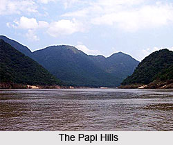
The district of West Godavari has immense potential for tourism. The region has a lot of temples and places bearing historical heritage. Some of the important tourist destinations of the area are Kolleru Lake, which is the largest fresh water lake in Asia. The Papi Hills and the Indira Sagar Project of the area are also major tourist attractions. Besides these tourist spots, the villages of West Godavari are well known for their natural beauty. Almost all the areas in the villages have a combination of pleasant climate and lush green fields.
Temples of West Godavari District
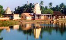 Someswara Aalayam Temple
Location: Kotipalli, West Godavari
Deity: Lord Shiva
Legend: This area is connected with Puranic legend and personages. It is here, according to legends, Indra, installed a great Sivalinga and offered Jalabhishekam to the Lord with the water from one crore rivers hence the name Koteeswara linga. Another legend states that the Moon-god got rid of his sin by bathing in the Pushkarini and worshipping the icon of Somasekhar installed under the guidance of Brihaspathi. He got back his lusture with the grace of Lord Siva; hence the deity is called Chaya Someswaraswamy. It lies 12 km off Draksharama in West Godavari.
Tirumala Mallikarjuna Aalayam Temple
Location: Dwaraka, West Godavari
Deity: Lord Shiva
This shrine is famous in history as the famous Hariharakshetra and enshrines both Siva and Vishnu temples. The Siva Aalaya is located at the head, and the Venkateswara at the tail of the hill, which confirms the legendary description that the hill is the terrestrial form of Anantha - the divine couch of Srimannarayanan. Of course, the Venkateswara Aalaya has out- shadowed the Siva shrine. This temple lies 12 km off Bhimadole.
Gangeswaraalayam Temple
Location: Tadikalapudi, West Godavari
Deity: Lord Shiva
 This lies in Tadikalapudi village at a distance of 20 km to Eluru in the West Godavari district of Andhra Pradesh. An ancient temple with a fascinating tale. It was originally built by Bhishma. The Sivalinga is called Gangeswara Sivalinga is Swayambhu.
Legend: It is believed that, once an ardent devotee was advised by Lord Siva to build an Aalaya for him in that sacred place itself, and if he neglected His bidding. He would grow to unusual height. Fearing evil consequence, the people built an Aalaya and drove a nail on the top of Sivalinga to stop its growth. Siva kept up His word and the devotees were blessed. There is another Aalaya for Sri Rama here and it is equally famous.
Golinageswara Swamy Aalayam Temple
Location: Nidadavole near Kovvuru, West Godavari
Deity: Lord Siva
This place was called Niravadyapuram after the title Niravadya of the Prince Vijayaditya of the Western Chalukyas. He built this temple after a cowherd found a big Sivalinga. The king diverted huge sums of money. The temple has many deities along with Rajarajeswari Devi, the consort of Lord Siva. When excavations were carried out intensively in 1943, many idols, such as Nandi and a big Sivalinga were found and installed in mini shrines.
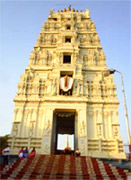
Bhimavaram Someswara Temple
Location: West Godavari
Deity: Moon God Soma as Linga
Architecture: The temple tank is known as Chandra Pushkarini. The Someswara lingam (crystal) is said to glow differently depending on the phase of the moon. The Shivalingam is five feet high and is housed in a two-storied sanctum, with Annapurna - Parvati on the second floor.
Festivals: The Mahasivaratri festival is celebrated in great splendour here.
Bhavanarayanaswamy Aalayam Temple
This is an ancient site and was called Swarnapuri and Ponnur. Chalukyas patronized the temple. This was the site for literary activities by the sages and literary luminaries. The deity Bhavanarayanaswamy, is said to have presiding over them and was called Sakshi Bhavanarayana Swamy popularly. The temple is big and possesses fine sculptures.
Ksheerarama Pancharama Temples
The white marble Shivalingam is called Ramalingeswara Swami as well as Ksheeraraameswaraswamy. It is considered to be one of the five-pancharama Shiva shrines of Andhra Pradesh. The five pancharama temples are Draksharama, Kumararama, Ksheerarama and Bheemarama and Amararama.
Recently updated articles in States of India

History of Thissur District
Early History of Thissur District explains flourishing of the port cities. Now these port cities are transformed into archaeological sites.

Tippi Orchid Research Centre, Arunachal Pradesh
Tippi Orchid Research Centre in Arunachal Pradesh is renowned for its rich collection of exotic and endangered orchids. Surrounded by lush rainforest...

Tourism in Nashik District
Pilgrimage tourism in Nashik district involves visiting the various places of Hindu and Jain worship located here. Some of the holiest sites for Hind...

Mangadu, Kerala
Mangadu in Kerala’s Kollam district is a significant megalithic site known for its urn burials, cist burials, menhirs, and stone circles. Excavations...

Devaswom
History of Devaswom is not very ancient and can be dated back to late seventeenth century.
Related articles in States of India

East Indian States
East Indian States comprises of Bihar, Jharkhand, West Bengal, Odisha and also the Union Territory of Andaman and Nicobar Islands. It defines the cult...

Purnia District in Bihar
Purnia District is located in Bihar and extends from River Ganga to Nepal. The district has a rich Hindu history and glorious past.

Hooghly district
Hooghly District along the bank of the river Hooghly is one of the principal trading ports of West Bengal.

Geography Of Chittoor District
Geography of Chittoor district is spread along the topography of the land which is divided into two natural divisions; Chittoor has a dry and healthy...

Districts of West Bihar
Districts of West Bihar is comprised of medieval monuments that were built by the different governors of Mughal era.