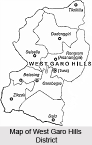
 West Garo Hills District is located in the westernmost part of Meghalaya. The district headquarters of West Garo Hills is Tura, which is the second largest town in the state after Shillong. West Garo Hills District is one of the largest districts of Meghalaya. Garo Hills District was divided into two districts, namely West Garo Hills District and East Garo Hills District in October 1976. The erstwhile West Garo Hills District was further divided into two administrative districts of West and South Garo Hills districts on June 1992. Total area occupied by West Garo Hills District is 3714 sq kms.
West Garo Hills District
West Garo Hills District is one of the administrative districts of Meghalaya. Tura is the district headquarters. Culture of West Garo Hills District is basically tribal in nature as it is mainly inhabited by the Garo Tribe.
Introduction
West Garo Hills District is located in the westernmost part of Meghalaya. The district headquarters of West Garo Hills is Tura, which is the second largest town in the state after Shillong. West Garo Hills District is one of the largest districts of Meghalaya. Garo Hills District was divided into two districts, namely West Garo Hills District and East Garo Hills District in October 1976. The erstwhile West Garo Hills District was further divided into two administrative districts of West and South Garo Hills districts on June 1992. Total area occupied by West Garo Hills District is 3714 sq kms.Location of West Garo Hills District
West Garo Hills District is situated approximately between the latitudes 90 degree 30 minutes and 89 degree 40 minutes east, and the longitudes of 26 degree and 25 degree 20 minutes north. West Garo Hills District is bounded by East Garo Hills District on the east, by South Garo Hills on the south-east, by Goalpara District of Assam on the north and north-west and by Bangladesh on the south.
History of West Garo Hills District
 History of West Garo Hills District is veiled in clouds of mystery. The earliest ancestors of the residents of Garo Hills are known to be Meches, Koch Tribe, Kacharis and Chutiyas who are said to have arrived from the north-western parts of the country. Other traditions also assert that the Garos are descendants of people who belonged to Asong Tibergori. Yet another historical tradition claims that the origin of the Garos belonging to Kamrup Plains can be traced to from their forefathers who had migrated from the Himalayan mountain range and approached Gondulghat.
After halting briefly at Gondulghat, they were believed to have proceeded towards a place called Sadiya, from which place they finally reached the northern bank of Brahmaputra River. They then trekked to Amingaon and altered their course to occupy Kamakhya after they had crossed Brahmaputra River. Kamakhya was the region where they settled till the time when the Koches invaded the kingdom of the Garos.
From Gauhati, they are said to have traversed to the external Garo Hills. Innumerable Garos also crossed the north-eastern hills of Garo and arrived in Mymensing in the country of Bangladesh. The earliest immigrants settled at the place termed as Goalpara while the later immigrants resided in Kamrup. Historical evidences prove that there have been gory sagas of battles and violent fights which took place between neighbouring villages or families dwelling in the Western Garo Hills.
 Medieval History of West Garo Hills District
The people of the West Garo Hills consisted of numerable `Nokmaships`, which implies vast expanses of plain lands which are located, near the foothills of Garo. Many renowned `Zamindari` estates were based in these portions of the country which later were modified into complexes. During the age of the Mughals, Garo Hills possessed several estates like Bijini in the Eastern Duars, Mechpara and Habraghat in the district of Rongpur, Kalimalupara, Karaibari, Sherpit and Susang in the district of Mymensing, Bangladesh. The local people of Garos were in regular internal disputes with the local Zamindars of these estates.
Modern History of West Garo Hills District
About the end of the 18th century, the regional tribes of Garo started communicating with the British. This was done after the Mughals lost control of the Diwani of Bengal, due to the efforts of the British East India Company. As a consequence, the large estates of Garo Hills which were once independent were then annexed by the British Empire in India.
However, despite the passage of power from the British to the Mughals, the British did not intend to gain control over the estates of Garo Hills immediately. This occurred because the Zamindars did not experience any interference in the private management of their estates. Political conflicts between the regional inhabitants of Garo Hills and the Zamindars worsened, which compelled the British to take control of the situation. This prompted the steady annexation of the Garo Hills by the British in the year 1873. The district`s very first Deputy Commissioner was Captain Williamson. The Garo district was divided into two districts, namely West Garo Hills and East Garo Hills in October 1879.
Garo Architecture in West Garo Hills District
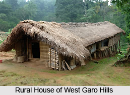 Garo architecture in West Garo Hills District is beautiful and this entire region exhibits similar type of architectural characteristics. Bamboo, timbers, thatch and cane are the substances which are utilized in the process of constructing houses in West Garo Hills. `Nokmong` is a special type of house in this area which is inhabited by `A`chik` households which are equipped with water storage spaces, kitchen, cattle sheds, hearth, pig sty, hencoop, bedroom and other important rooms.
`Nokpante` is another kind of house where young bachelors reside. Young boys of West Garo Hills are trained in the arts of several games in the Nokpante. The training is imparted by senior boys. This type of house is built in the premises of the chief or the `Nokma`. Small huts known as `Jamsreng` are also created by the local people of West Garo Hills. Food grains and fruits are preserved in the Jamsreng and sometimes they are utilized while sleeping.
Constructed in the Jhum fields, the field house or `Jamatal` is a miniature home. `Borang` is a marvellous house which is constructed on the top of trees and contains a ladder which protects the house from wild beasts. A rest house, known by the name `Bandasal` is built near the house of the chief or the Nokma.
Granaries or store houses called `Jam Nok` are constructed in West Garo Hills District for the purpose of conserving paddy and millets. This is created at a distance of about 30 or 40 metres from the main house. Jam Nok safeguards the house from the hazards of fire.
Geography of West Garo Hills District
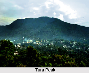
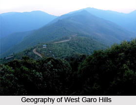 Geography of West Garo Hills District is mostly hilly with plains fringing the northern, western and the south-western borders. Tura Range is one of the most important mountain ranges in the West Garo Hills District. The Tura range is about 50 kms long and extends in the east-west direction from Tura to Siju in the South Garo Hills district. The mountain peaks that are located in this range are Tura Peak, Nokrek Peak, Meminram Peak, Nengminjok Peak and Chitmang Peak. The highest peak of this range is the Nokrek (1412 metres) around 13 kms south-east of Tura. To the west of Tura range, low hill ranges run from north to south, and to the north of the Tura range, hill ranges run parallel to it, gradually increasing in height till they meet in the south. These ranges are rich in diverse species of flora and fauna.
The climate of West Garo Hills District is largely controlled by South-West monsoon and seasonal winds. West Garo Hills District being relatively lower in altitude experiences a fairly high temperature for most part of the year. The average rainfall is 330 cm of which more than two-thirds occur during the monsoon. Winter season is practically dry.
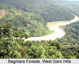
Geography of West Garo Hills District also includes several river systems. Tura range form watersheds in West Garo Hills District, from which the rivers flows towards Bangladesh plains in the south and the Brahmaputra valley in the north and in the west. The important rivers of the north group are Kalu, Ringgi and the Didak. The important rivers of the southern group are the Bhogai, Darrang etc. The Tura range is also the source of the Simsang (Someswari) River, one of the major rivers of Meghalaya. Someswari River is the largest and the second longest river in West Garo Hills District. The river is locally known as Simsang. It starts from Nokrek Mountains and runs towards the east, passing through Williamnagar, Nongalbibra, Siju, Rewak and lastly Baghmara. The upper course of this river is not navigable however the lower course has many deep pools and falls. They are Mirik, Matma, Jamiseng, Warisik, Bobra, Goka, etc. The chief tributaries are Chibok, Rongdik, Rompa and Ringdi rivers.
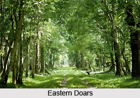
Geography of West Garo Hills District has mostly dense tropical mixed forests and a small patch of temperate forests in the higher parts of the Tura range. Several mineral resources are also found this district like Coal, Limestone, Phosphorus, Gypsum and Glass sand.
Demography of West Garo Hills District
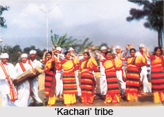
As per 2001 Census, total population of West Garo Hills District is 5,18,390, majority is rural population that is near about 4,59,412 and urban population is 58,978. The population of West Garo Hills District is pre-dominantly inhabited by Garo tribe, a tribe with a matrilineal society belonging to the Bodo family of the Tibeto-Burman race tribes. Other indigenous inhabitants are the Hajongs, Rabha tribe, Koch tribe, Rajbansis, Meches, Kachari and Dalus. The district is also inhabited by Bengalis, Assamese, Nepalese, Marwaries, Biharis and people from other parts of India.
Administration of West Garo Hills District
Administration of West Garo Hills District is under the in-charge of Deputy Commissioner. In West Garo Hills, there are two Additional Deputy Commissioners and four Extra Assistant Commissioners. The Deputy Commissioner`s office is divided into a number of important branches. These branches are the General or Establishment Branch, the Judicial Branch, the Registration Branch and other branches in charge of Supply, Housing, Elections, Block Development as well as the District Selection Committee. Garo Hills District Council came into being in the year 1952 under the provisions of the Sixth Schedule of the Constitution of India. In domestic matters, wide powers are exercised by the Nokma of individual villages. He is the head or chief of the dominant clan within the territorial limits. There are Laskars and Sardars recognized by District Council who have a certain measure of magisterial powers. West Garo Hills District comprises eight Community and Rural Development Blocks namely Rongram Development Block, Dadenggre Development Block, Dalu Development Block, Betasing Development Block, Selsella Development Block, Tikrikilla Development Block, Zikzak Development Block and Gambegre Development Block.
Education in West Garo Hills District
Education in West Garo Hills District made insufficient progress until the year 1911. The American Baptist Mission was in charge of propagating academics in the West Garo Hills, whose activities revolved around some regions which contained its Mission Stations.
Prior to 1911, a meagre quantity of 23 percent of people was literate. Till 1951, the field of education in this region failed to display proper development and growth. The 1951 Census has asserted that the local literacy rate in this Indian district was just 7.3% as opposed to the All-India average literacy rate of 16%. Post Indian independence, this rate started showing signs of growth.
 According to the Population Census of 2011, West Garo Hills District boasted of a literacy rate of 67.58. 2011 census maintained the male literacy rate at 72.39 and 62.70 as the female literacy rate. The aggregate number of literates in West Garo Hills District was 3, 58,702 from which 1, 65,264 were females and 1, 93,438 were males.
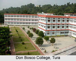
The Tura Government College was the one and only college in the area of Tura, which was the district headquarters of West Garo Hills. This was till the year 1981. Presently, four colleges namely Durama College, Tura Government College, Abong Noga College and Don Bosco College are existent in this place. Don Bosco Teachers Training College and College of Teacher Education are the two educational institutes which provide Bed degree to students. Tura Law College offers LLB course which is a three-year programme. Normal Training School and DIET provide teachers training at Tura.
Schools at Tura are under the Meghalaya Board of School Education (MBOSE). Kendriya Vidyalaya and Tura Public School are the exceptions and they offer CBSE and ICSE courses. ITI and Regional Vocational Training Institute (RVTI) are the vocational institutes located at Tura. Physically disabled children are offered education by the Monford Centre for Education. MBA , post graduation courses in English, RDAP or Rural Development & Agricultural Production and education are provided by the Campus of North Eastern Hill University. Courses in the discipline of PHD degree are also conducted to the students of this academic institute. Tura also possesses a centre of the Indira Gandhi National Open University or IGNOU. Tura also shelters the Achick Theological College for Baptists and St. Peter`s Seminary for Roman Catholics which are theological colleges.
Vocational Educational Institutes in West Garo Hills District
West Garo Hills consists of Tura Polytechnic, College of Home Science, Industrial Training Institute, and Regional Vocational Training Institute for Women. RVTI for Women is known to conduct courses on several streams like beautician courses, tourism, dress making, computer operator and secretarial practise amongst some others. Subjects like Family Resource Management, Food Science and Nutrition, Human Development, Clothing and Textiles are the various disciplines on which courses are offered. The Industrial Training Institute provided technical courses to students who seek to become carpenters, motor mechanics, electricians, welders and fitters. Typing and stenography are also taught to the students of Industrial Training Institute.
Tura Polytechnic College is located in Shillong and is affiliated to the All India Council for Technical Education or AICTE. The diploma courses conducted by this institute are under the Meghalaya State Council for Technical Education or MSCTE, Shillong. Diploma courses in Food Processing and Preservation Engineering/ Technology, Medical Electronics and Computer Applications are also being offered by this institute.
West Garo Hills also comprises a Training-cum-production Centre which was set up on 1st March, 1976 which offered training to women belonging to the districts and imparted lessons to them in fields like weaving, knitting, tailoring and embroidery.
Prior to 1911, a meagre quantity of 23 percent of people was literate. Till 1951, the field of education in this region failed to display proper development and growth. The 1951 Census has asserted that the local literacy rate in this Indian district was just 7.3% as opposed to the All-India average literacy rate of 16%. Post Indian independence, this rate started showing signs of growth.
According to the Population Census of 2011, West Garo Hills District boasted of a literacy rate of 67.58. 2011 census maintained the male literacy rate at 72.39 and 62.70 as the female literacy rate. The aggregate number of literates in West Garo Hills District was 3, 58,702 from which 1, 65,264 were females and 1, 93,438 were males.
The Tura Government College was the one and only college in the area of Tura, which was the district headquarters of West Garo Hills. This was till the year 1981. Presently, four colleges namely Durama College, Tura Government College, Abong Noga College and Don Bosco College are existent in this place. Don Bosco Teachers Training College and College of Teacher Education are the two educational institutes which provide Bed degree to students. Tura Law College offers LLB course which is a three-year programme. Normal Training School and DIET provide teachers training at Tura.
Schools at Tura are under the Meghalaya Board of School Education (MBOSE). Kendriya Vidyalaya and Tura Public School are the exceptions and they offer CBSE and ICSE courses. ITI and Regional Vocational Training Institute (RVTI) are the vocational institutes located at Tura. Physically disabled children are offered education by the Monford Centre for Education. MBA , post graduation courses in English, RDAP or Rural Development & Agricultural Production and education are provided by the Campus of North Eastern Hill University. Courses in the discipline of PHD degree are also conducted to the students of this academic institute. Tura also possesses a centre of the Indira Gandhi National Open University or IGNOU. Tura also shelters the Achick Theological College for Baptists and St. Peter`s Seminary for Roman Catholics which are theological colleges.
Vocational Educational Institutes in West Garo Hills District
West Garo Hills consists of Tura Polytechnic, College of Home Science, Industrial Training Institute, and Regional Vocational Training Institute for Women. RVTI for Women is known to conduct courses on several streams like beautician courses, tourism, dress making, computer operator and secretarial practise amongst some others. Subjects like Family Resource Management, Food Science and Nutrition, Human Development, Clothing and Textiles are the various disciplines on which courses are offered. The Industrial Training Institute provided technical courses to students who seek to become carpenters, motor mechanics, electricians, welders and fitters. Typing and stenography are also taught to the students of Industrial Training Institute.
Tura Polytechnic College is located in Shillong and is affiliated to the All India Council for Technical Education or AICTE. The diploma courses conducted by this institute are under the Meghalaya State Council for Technical Education or MSCTE, Shillong. Diploma courses in Food Processing and Preservation Engineering/ Technology, Medical Electronics and Computer Applications are also being offered by this institute.
West Garo Hills also comprises a Training-cum-production Centre which was set up on 1st March, 1976 which offered training to women belonging to the districts and imparted lessons to them in fields like weaving, knitting, tailoring and embroidery.
Economy of West Garo Hills Distri
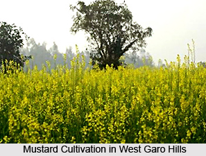 Economy of West Garo Hills District is agrarian in character. Majority of the people of this district of Meghalaya depends on agriculture for their livelihood. The main crop being paddy, the other crops cultivated in West Garo Hills District are mustard, sugarcane, jute, potato, tapioca, cotton, etc. The sizeable crops with commercial potential cultivated in the district are chillies, ginger, pineapple, turmeric and also banana.
Wet rice cultivation is practiced in the plain areas of West Garo Hills District while in the hills, the population practice jhum or shifting cultivation. With the passing of time, and the increasing pressure of population, the jhum cycle has been considerably reduced, averaging three years instead of the norm of seven year. The practice has led to extensive denudation of forests and progressive destruction of the ecology. Most of the existing cultivation is found around villages. Normally, allocation of plots is based on precedents and a family cultivates the same plot for about two years. After cleaning of the jungle and burning of the litter some time between March and April, cereals like maize and millets are sown. West Garo Hills District with its undulating topography and high intensity of rainfall, suffers acute erosion problem and ecosystem degradation. The problem is further compounded by unscientific agricultural practices such as shifting cultivation on steep slopes, rampant deforestation, burning, etc., which has resulted in degradation of land and water resources.
Horticulture also constitutes the economy of West Garo Hills District. Due to widespread practice of shifting cultivation and deforestation, Agriculture Department has taken up Horticulture in the district as the topmost priority. West Garo Hills District with a wide variety of agro-climatic conditions, soil and rainfall provide opportunities for growing varied range of horticultural and plantation crops. Diary farming, poultry and bee-keeping are also practiced in West Garo Hills District. Most of the economic mineral resources of West Garo Hills District are associated with the Eocene Tertiary, Sedimentary formation. These minerals are Coal, Limestone, Lithomargic clay, Fireclay, Phosphorite, Gypsum and Glass sand. Phosphorite, Gypsum and Glass-sand deposits found so far are not of economic importance.
Further, occupational mobility is a noticeable phenomenon. The literacy rate of the district is on increase and people are opting for professions other than traditional agriculture. Many are employed outside West Garo Hills District.
Natural Resources in West Garo Hills District
 Natural Resources in West Garo Hills District consist of the diverse flora and fauna of the region as well as the variety of mineral resources which are available in West Garo Hills District.
Flora of West Garo Hills District
The West Garo Hills is a plateau wherein Nodrek is the highest point which has an altitude of 100 to 1400 metres above sea level. The flora of this region can be categorised into tropical and sub tropical. Dense forests of Rewak, Rongrenggre, Rongchugre, Dilma, Phulbari, Songsak, Singimari, Dhima, Emangre, Siju, Darugre, Rajasimla Ildek, Baghmara and others represent the main vegetation of West Garo Hills. Bamboo trees, deciduous, evergreen and semi-evergreen forests are the other trees found here. Mosses, liverworts, ferns, asteraceae, balsaminanceae, etc. Nodrek Peaks, Tura Peak and others are home to sub tropical vegetation though some deciduous trees are also noticed here. Epiphytic orchids, moss, liverworts and ferns are also common in these portions of the country.
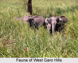
Fauna of West Garo Hills District
Mammalian fauna are present in West Garo Hills District.
| Hoolock gibbon | Stump-tailed macaque | Rhesus macaque |
| Assamese macaque | Slow loris | Golden langur |
| Capped langur | Common monkey | Tiger |
| Leopard | Clouded leopard | Golden cat |
| Leopard cat | Marbled cat | Jungle cat |
| Large indian civet | Masked palm civet | Binturong |
| Indian grey mongoose | Indian fox | Himalayan black bear |
| Yellow throated marten | Yellow-bellied weasel | Madras tree shrew |
| Indian flying squirrel | Malayan giant squirrels | Bandicoot rat |
| Lesser bamboo rat | Black napped hare | Rufous-tailed hare |
| Sambhar | Gaur | Indian crested porcupine |
| Cheetal | Muntjac or barking deer | Indian elephant |
| Wild dog | Indian wild boar | Different species of bats |
 West Garo Hills is inhabited by innumerable varieties of birds like green Himalayan barbet, white-crested laughing thrush, Scarlet Minivet, Yellow bulbul, brown fish owl, grey-headed sibia, Cuckoo -shrike, bee-eaters, white-capped redstart, black-headed oriole, magpie robin, slaty-headed scimitar babbler, swallow-shrikes, hill myna and others.
| Indian black baza | Barred jungle owlet | Red jungle-fowl |
| Thick-billed green pigeon | Blue throated barbet | Long-tailed broadbill |
| Grey-Headed Myna | Jungle myna | Green magpie |
| Indian house crow | Red winged crested cuckoo | Large green-billed malkoha |
| Crow pheasant | Red headed trogon | Redwattled lapwing |
| Burmese roller | Broad-billed roller | Spur-winged plover |
| Indian three-toed forest kingfisher |
Different types of snakes can be noticed in this area which includes vipers, Indian cobra, red necked keelback, blind snakes, checkered keelback, Indian gamma, etc. Various species of lizards, turtles, geckos are also present.
Tourism in West Garo Hills District
 Tourism in West Garo Hills District means a delightful and memorable experience for the visitors. The beautiful hills and peaks enhance the overall tourism experience. Tourism in West Garo Hills District includes visits to several places of archaeological importance. There is no dearth of tourism options in this district of Meghalaya. All these options attract people (both nature lovers and adventurous people) from different parts of the country.
Popular places of tourist interest in West Garo Hills District are as follows -
Tura Peak: This majestic hill stands on the eastern side of Tura, the largest town in the Garo Hills region of the state. Its elevation is around 872 metres above the sea level. Local legend says that the peak provides a sacred abode for `Gods` and claims that it was traditionally known as `Dura`. Since Tura hill and its peak constitute the water catchments area of Tura town, the whole Tura-range has been declared as a reserve-forest. It offers a magnificent view of the lower Brahmaputra Valley as well as the beautiful plains of Bangladesh.
Bhaitbari: Bhaitbari is a small village of the district located on the Mankachar-Phulbari-Goalpara road, on the western frontier of the state, adjoining Goalpara District of Assam. Standing on the banks of river Jinjiram, the village spreads across the narrow stretch of plain lands of the state, bordering the central hilly plateau.
Kata Beel: Located near Nogorpara village in West Garo Hills District, the beel is about 70 kms off Tura. Tradition has it that this pond was constructed under the instructions of king of the Garos. The beautiful, soothing waters of Kata Beel covers about one hectare of area. The beel is surrounded by planned palm plantations. Kata Beel is a major fishing ground of Garo Hills.
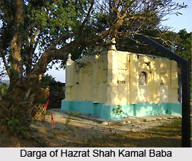 Darga of Hazrat Shah Kamal Baba: The Darga Sharif of Hazrat Shah Kamal Baba is popularly known as Pirsthan. Devotees from various parts of the country come to the Pristhan for annual prayer.
Nokrek: The highest point of the Garo Hills region of the State, Nokrek Peak stands 1412 metres above sea level. All important rivers and streams of the Garo Hills region rise from the Nokrek Range. Nokrek can be reached from the Tura-Asanang-Daribokgre Road.
Arbella Peak: A lofty blue hill with an elevation of 999 metres above sea level stands on the north-eastern border of Tura. The hilly range on which it is located is known as Arbella Range and the peak as Arbella Peak.
Sasatgre: Sasatgre village is located at the foot of the Nokrek peak in the West Garo Hills District. The distinguishing feature of this village is that although all the houses are built in the typical Garo Pattern and design, they are spacious, airy, well-built and firm. Sasatgre Village has been blessed by nature and is surrounded by dark green orange bushes, which are highly productive.
Asanangre: Asanangre is a large Garo village where the headquarters of the Rongram Community and Rural development block is located. It is also the venue of Wangala Dance festival which has become a popular tourist attraction.
Mir Jumla`s Tomb and Rangbang Falls are other popular attractions of West Garo Hills District.
How to Reach West Garo Hills District
Tura, the headquarters of the district, is well connected by road with other places in the district as well as with the rest of the Meghalaya and Assam. Guwahati is the nearest railhead. Helicopter services are available from Tura to Shillong and Guwahati.
Culture of West Garo Hills District
 Culture of West Garo Hills District is inclusive of the individual tastes and traditions of the various local tribes who reside in the region of West Garo Hills. They follow the pattern of a matrilineal society which consists of the children, husband and his wife. The youngest daughter of the family occupies a significant social status and is referred to as `Nokna` and her husband is termed `Nokrom`. She is entitled to a lion`s share in the property of her mother and the remaining portion of the property is shared by her other sisters. The utensils utilized by the regional people of West Garo Hills District are earthenware containers, cooking pots, mortar and pestle and some others. Different kinds of bamboo baskets are popular amongst the local people of this region.
Wooden stools, bamboo floors, cane or bamboo chairs are some of the rare pieces of furniture which are favoured by the local inhabitants of West Garo Hills District. Most of the items of furniture used by these people are home-made. They are fond of weapons and are known to use two edged swords which are termed as `Milam`, and composed of a single piece of iron. Other commonly used weapons include daggers, bows, spears, arrows, axes and others.
Rice forms the staple diet of the people of West Garo Hills. Tapioca, millets, maize, etc are the other food grains which are consumed by them. Non-vegetarian food items are also relished by the people of this region. Dense forests and the fields of Jhum offer abundant sources of vegetables like bamboo shoots which appeal to the taste-buds of the Garo people. Dry stems of plantains are burned in order to derive potash which is used in curries. These curries are locally termed as `Kalchi` or `Katchi`. Liquor is also savoured by the local residents.
 Cotton represents the main textile of this part of the country since Garo`s principle cash crop is cotton. Local men are clad in a piece of woven cotton cloth which measures about six inches id width and six feet in length. Some of their cotton garments are embellished with a series of conch shells or white beads. Sometimes, the men of West Garo Hills can be noticed wearing black coloured vests which possess a lining near its ends. Body cloths are used by the local womenfolk who are accompanied by a skirt known as `Dakmanda`. A colourful headband completes the attire of a typical lady belonging to the West Garo Hills District. Jewelleries are cherished by these people and worn by men as well as women. Ornaments like `Natapsi` which implies a string of beads which are worn in the upper portion of the ears, `Ripok` which are necklaces composed of silver or brass, `Jaksan` which means bangles manufactured from various substances, `Pilne` which is a head jewellery which is used by the local ladies of Garo Hills during dances and `Jaksil` which is a elbow ring that is worn by the rich men-folk during Gana ceremonies.
As per the traditions of the West Garo Hills District, girls propose marriage to the boys. The laws of `A`Kim` and `Exogamy` govern the laws of marriage in this region. No marriages can be legalised if the bride and groom belong to similar castes. In case of the death of a woman, her sister should marry her husband. If a man dies, his wife has to marry one of his nephews. However, is such a match cannot be found, the marriage is called off and nullified and the woman or man is given the right to marry a person of their choice.
The Garos believe in the existence of a Supreme God who is revered as `Dakgipa Rugipa Stugipa Pantugipa` and also `Tatora Rabuga Stura Pantura` which implies the `creator`. Monotheism occupies a prominent place in the religion of the people of West Garo Hills. Christianity, Hinduism, Pantheism and Buddhism are some of the religions practised by the regional inhabitants of West Garo Hills District. They worship numerous Gods like `Susince` or Goddess of Riches, `Choradubi` or the protector or crops, `Saljong` or God of Fertility and `Goers` or God of strength. Such Gods are thought to protect them from all kinds of disasters, ill fates, and their blessings are invoked during social occasions like marriages, births, etc.
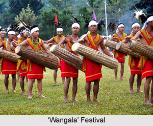
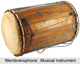
Regular festivals are celebrated with great pomp by the people of West Garo Hills District. `Wangala` is an important local festival which involves the ritual of thanksgiving to Gods for good harvest. It is carried out in the month of October and sometimes November. Drums and gongs are beaten while horns are blown to mark this special festive occasion. Dances like `Chambil mpa`, `Gaewang roa`, `Ajima roa`, `Napsepgrika` and many others are popular in this portion of India. Musical instruments of these people comprise aerophone, idiophones, membranophone, chordophone and others.
Recently updated articles in States of India

History of Thissur District
Early History of Thissur District explains flourishing of the port cities. Now these port cities are transformed into archaeological sites.

Tippi Orchid Research Centre, Arunachal Pradesh
Tippi Orchid Research Centre in Arunachal Pradesh is renowned for its rich collection of exotic and endangered orchids. Surrounded by lush rainforest...

Tourism in Nashik District
Pilgrimage tourism in Nashik district involves visiting the various places of Hindu and Jain worship located here. Some of the holiest sites for Hind...

Mangadu, Kerala
Mangadu in Kerala’s Kollam district is a significant megalithic site known for its urn burials, cist burials, menhirs, and stone circles. Excavations...

Devaswom
History of Devaswom is not very ancient and can be dated back to late seventeenth century.
Related articles in States of India

East Indian States
East Indian States comprises of Bihar, Jharkhand, West Bengal, Odisha and also the Union Territory of Andaman and Nicobar Islands. It defines the cult...

Purnia District in Bihar
Purnia District is located in Bihar and extends from River Ganga to Nepal. The district has a rich Hindu history and glorious past.

Hooghly district
Hooghly District along the bank of the river Hooghly is one of the principal trading ports of West Bengal.

Geography Of Chittoor District
Geography of Chittoor district is spread along the topography of the land which is divided into two natural divisions; Chittoor has a dry and healthy...

Districts of West Bihar
Districts of West Bihar is comprised of medieval monuments that were built by the different governors of Mughal era.