 Sindhudurg district is situated between the north latitudes of 15.37 and 16.40 and the east longitudes of 73.19 and 74.18. The district is surrounded by the Arabian Sea on the west, the Belgaum District (Karnataka) and Goa on the south and the Ratnagiri district on the North. The Sahyadri hill ranges lie to the east. Covering a total area of 5207 Square Kilometres, the district of Sindhudurg lies in the Konkan area of Maharashtra, comprising both the seashore as well as mountains. National Highway 17 passes through this area. With 7 railway stations, a 103 Km stretch of Konkan Railway line passes through this district. It has good road and rail links with Goa and Mumbai. The population of the district according to the last Census report of 2001 is 8, 68,825. The majority of the population is rural, with the rural population comprising almost 91 percent of the same.
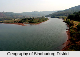
Sindhudurg being a coastal district, the climate is generally moist and humid and the temperature variations during the day and throughout the seasons are not large. The maximum temperatures touch 33.8 degree Celsius, whereas the minimum temperatures hover around 16.3 degrees Celsius. The district receives rain for full four months i.e. June, July, August and September. The average rainfall in the district is around 3,287 mms. Though the average rainfall is rather high, almost all the rainwater causes surface run off, due to undulating topography and lack of any water impounding major and medium structures. Among the important rivers flowing through the district are Terekhol River, the Gad River, the Devgad River, the Karli River and the Vaghotan River. The most important crops grown in the district are rice, coconut, kokam, mango and cashew. The annual crops are kolam, mango and cashew. A large part of the land holdings in the region, almost 74 percent, are held by small and marginal farmers. There are two major irrigation projects in the district, namely Tilari and Talamba.
Most of the district area is covered by dense rain forests. The Amboli hill station area has proved to be a most suitable habitat for wild animals like leopard, wild cats, rabbits, wild hen and some times wild buffalo also appears in winter season. Apart from this, elephant and wild buffalos are also found in the district.


