 Revenue
: Mallapuram district is consisting of two Revenue Divisions, six Taluks, and 135 villages. Some of the important functions of revenue department are revenue recovery, building tax, assignment of Government Land, assignment of surplus land, lease, citizenship registration, explosive license and magisterial powers, election, etc.
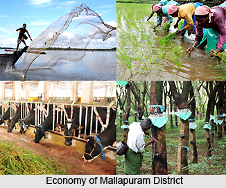
Agricultural activities: The Agriculture Department in Malappuram District is taking sincere effort for carving out a dynamic and vibrant agriculture sector. This is responsive to the needs of local farming community.India`s first food technology park is at Kakkancherry in Mallapuram.
The role and responsibility of Krishi Bhavan and the basic contact point of the farming community is very significant in planning, formulation and execution of viable and need based programme. Krishi Bhavan also acts as an effective transfer of technology agents in the agricultural sector. The following are some of the important schemes implemented by the department: State sector scheme for rice and paddy, Central sector scheme for coconut, intensive vegetable development programme, etc.
Fisheries: The Mallapuram district has 70 km of seacoast. It extends from Kadalundi Nagaram in the north to Palappetty in the South. The coastal belt is in many places. The main fishing centers are at Ponnani, Koottayi, Parappanangadi, and Tanur. Out of these centers Ponnani is a major fisheries port with about 350 mechanized boats. High sea fish catching operations are centered in Ponnani and Parappanangadi. There are Fisheries guide lights, at Ponnani and Tanur to help night fishing.
There are various schemes to provide fishing equipments, houses, latrines and other amenities to fishermen. There are also educational assistance schemes, financial assistance for the benefits of fishermen during off-season. A Fish Farmer Development Agency or FFDA is there to promote inland fishing.
Animal husbandry: The functioning of Animal Husbandry can be classified into 7 groups. Viz. artificial insemination, treatment facilities, remedial measures for resisting diseases, schemes, production centers, is some of them.
Health services: A good network of health care units are functioning under the Government Sector. Modern medicines, Ayurveda and Homeopathy services are also available.
Co-operatives: The district has a good network of Co-Operative societies. All types of Co-operative activities ranging from ration shops to hospitals are undertaken under Co-operatives.
Scheduled caste development: The District has a scheduled caste population of 25,573. Some of the main communities are Pulaya, Paraya, Kanakka Panan, Mannaan, Perumannaan, Kalladi, Cheruma etc. In some of the developmental programmes Education is given priority for the Scheduled Castes.
The scheduled caste development department undertake various social welfare measures like house construction, providing land and house to the landless and houseless people, thatching and filling grants, sanitation latrine construction, lump sum grant and stipend to SC students, etc. This department also gives educational Assistance to Other Backward Communities, Other Eligible Communities, and financially backward students of forward communities.
National informatics center: The organizational structure of NIC comprehends its Headquarters at
Delhi; Regional centre at Pune,
Bhubaneshwar and
Hyderabad; State units in all the state Capitals and Union Territory Headquarters; and Offices in over all Districts of the country, respectively.
 Mass communication:
 : Malayala Manorama published from Malappuram, Mathrubhumi published from Kottakkal and Madyamam published from Perinthalmanna are the three newspapers published from the district. The evening daily Prehalika, is published from Tirur. A few periodicals, monthlies, fortnightlies and weeklies, which are devoted to this religion and culture, are also published. Since 1981 a capsule cultural monthly magazine Innu is being published from Malappuram. All the important daily newspapers published from other districts, have wide circulation in Malappuram district.
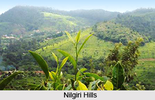
Education: : The Mallapuram district has achieved tremendous progress in the filed of education during the last decade. Great development has been made in the field of female education. There are various numbers of schools, colleges, B.Ed centers, polytechniques, teaching training institute, engineering colleges, oriental title colleges, etc present in this district. The Calicut University present in Tenhippalam in Malappuram district was established in 1968.Malapuram is India`s first fully e-literate district.World`s only teak meuseum is at Nilambur in Mallapuram.
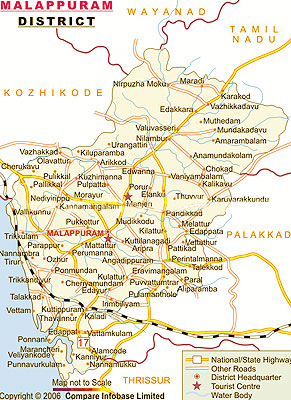
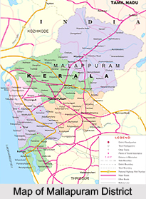 Mallapuram district was born on 16th June 1969. It is situated on the Calicut - Madras road that is at 12 km. southwest of Manjeri and 52 km. southwest of Calicut. Mallapuram is the head quarters of the district. In earlier times, Mallapuram was the headquarters of European and British troops and later it became the headquarters of the Malabar Special Police, which is known, as abbreviation is M.S.P.
 The historical legacy of the Malappuram district is one of a rich culture and tradition. Malappuram district took its birth on 16-6-1969. It is situated on the Calicut -
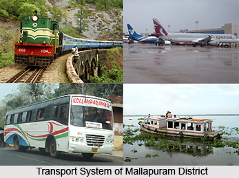 Airport : The Calicut airport is one of the most beautifully designed airports in India, which is situated at Karippur in Malappuram District. It is 26 Km away from Malappuram and 28 Km away from Kozhikode. It has a runway of 6000 x I 50 feet with night landing facilities. A huge project of extending the runway by 3000 feet with a view to facilitate landing of airbuses is under completion. Regular flights to Bombay, Bangalore, Madura, Coimbatore, Madras and gulf countries are operated presently. From 2002 onwards Calicut airport in Malappuram district has been recognised as the embarkation point for Haj pilgrims.


