 Geography of Malkangiri District is undulating with a large number of hills, streams, forests and moderate climate. The topography of this district of Orissa mainly possesses dense forest of dry deciduous type. Around 51 per cent of the total area of the district is covered with forests. Forests of this district yield Timber, Firewood and minor forest products like Tamarind, Kendu Leaves, Mahua Flower, Mahua Seeds (Thola), various types of fibres, oilseeds and medical plants.
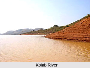
Geography of Malkangiri District includes major rivers such as Sabari River, Silleru, Potteru, Kolab River and Machkund. Regur Soil is mainly found in Malkangiri District. Deep black in colour, it contains a large percentage of organic matter. Further, sandy soils dominate the entire district. The chief hills of Malkangiri District are those that hedge in the valley of Machkund. These usually stand about 1000 feet above the bed of the river. The plateau descends into the low-lying tracts of Malkangiri about 900 feet high at their northern end and gradually falling away in a south-western direction to 150 feet high at Motu at the extreme south-western corner of the district. The rest of the district is comparatively flat plain. A number of rocky wooded hills break the monotony of the plain. A number of mountains and isolated hills such as Tulasi at Mathili, Shulia at Korukonda, Chitrakuta at Chitrakonda, Saptadhara at Govindapalli, Vhima at Daniguda, the Danga at Tandiki, Deva Dangara or Goi at Malkangiri, the Akuru at Akuru and in the border Golikonda at Bada Dural arise out of these tablelands.
The Climate of Malkangiri District is divided into four seasons, the hot season from March to June, the monsoon season from July to September, the post-monsoon months from October and November, and the cold season from December to February. The maximum temperature is around 47 degree Celsius and minimum temperature recorded is around 11 degree Celsius. Humidity varies widely between the monsoon months and the winter months. The district is affected by depressions from Bay of Bengal particularly in September and October that causes high wind and widespread heavy rain. The major minerals that are found throughout Malkangiri District are Tin, Limestone, Black Granite, Asbestos and Mica.
Geography of Malkangiri District
Geography of Malkangiri District includes streams, vast forests, plains and hilly terrains. It also includes a moderate climate. Dry deciduous forests are mainly found in the district.


