 The name old name for Kannur district was `Cannanore` which was the anglicized form of the Malayalam word Kannur. According to popular belief `Kannur` is a derivation from Kanathur, an ancient village. This village survives even today in one of the wards of Kannur Municipality. On other hand, there is another belief that associates the district name with Lord Krishna. `Kannur` refers to the place of Lord Krishna as because `Kannan` means Lord Krishna and `Ur` means place, in this context, it is worth mentioning that the deity of the Katalayi Sreekrishna temple was originally installed in a shrine at Katalayi Kotta in the South-Eastern part of the present Kannur town.
Kannur District
Kannur District is a key contributor to the cultural, religious, political and industrial heritage of the Indian state of Kerala.
Introduction
The name old name for Kannur district was `Cannanore` which was the anglicized form of the Malayalam word Kannur. According to popular belief `Kannur` is a derivation from Kanathur, an ancient village. This village survives even today in one of the wards of Kannur Municipality. On other hand, there is another belief that associates the district name with Lord Krishna. `Kannur` refers to the place of Lord Krishna as because `Kannan` means Lord Krishna and `Ur` means place, in this context, it is worth mentioning that the deity of the Katalayi Sreekrishna temple was originally installed in a shrine at Katalayi Kotta in the South-Eastern part of the present Kannur town.History of Kannur district
 The name of Kannur district has derived from the location of its headquarters at Kannur town. The old name was `Cannanore` which was the anglicized form of the Malayalam word Kannur. The history of Kannur is an engaging one. Though there is no evidence of the Paleolithic man living in this region. However, rock-cut caves and megalithic burial sites of the Neolithic age have come to light in certain parts of the district. History of Kannur therefore offers a scope to assume that the first batch of Aryan immigrants entered in to the state through the Tuluva region.
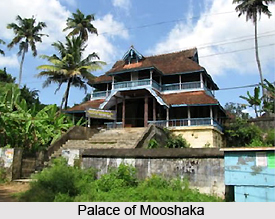
Mooshaka Kings and Kolathiris : It was in the ninth century AD the second line of the Chera emperors was established and ruled till 1102 AD. By the 14th century A.D., the old Mooshaka kingdom was reckoned as Kolathunad and the rulers were known as Kolathiris. Kolathiris, made their presence felt quite colossally in the northern Kerala.
Vasco Da Gamma : When in May 1498, Vasco Da Gamma, the famous Portuguese navigator, came to India he did not visit Kannur. But he established some contacts with the Kolathiri ruler. When his ships left Kozhikkode on August 29, 1498, Gama was invited by Kolathiri to visit the palace. The aim of the Kolathiri was to gain wealth and power with the help of the Portuguese in the same way the Zamorin had acquired with the help of the Arabs. Vasco Da Gamma, in turn, had successfully exploited the jealousies of the native princes and won for the Portuguese a virtual monopoly of the pepper trade.
Francisco De Alameda was sent from Portugal with specific instructions to put up forts at strategic points. With a view to this he started constructing the Kannur Fort in 1505 named it as St. Angelo.
On March 16, 1506, the Portuguese effectively grabbed an armada of Turks and Arabs, whom the Zamorin had launched against Kannur. The Portuguese navy under Lorenzo Almedia engaged the Zamorin`s fleet in battle and the Portuguese ships won a decisive victory. This naval victory resulted in the establishment of Portuguese naval supremacy in the Indian seas.
Portuguese Ascendency : An important political development, which took place at this point in time, was the alliance between the Kolathiri and the Zamorin who were enemies before that. The Zamorin was able to convince the Kolathiri and made him understand about the motives of the Portuguese. He also warned about the intrinsic dangers in his policy of befriending them.
The Portuguese followed a policy of religious persecution and forceful conversion. They therefore clashed with most of the native princes and chieftains. In 1558, the Kolathiri came openly into the field against the Portuguese by providing active support to the Kunjali Marrikkars of Kozhikkode. In 1564, the Kolathiri and the Zamorin fought a common war against the Portuguese and they attacked the fort of St.Angelo at Kannur. But the Portuguese continued to maintain an uncertain foothold at Kannur till 1663 when the Dutch captured the fort in February that year.
Arrival of the East India Company : At the end of 17th century the English East India Company got its first foothold in the district. This happened when it acquired a site at Thalassery for the manufacture of a fort and a factory.
The integration of the Kolathiri`s territory started in the latter half of the 17th and the beginning of the 18th century following dissensions in the royal family by the extensive surrender of territory to consorts of the ruling members.
In spite of the difficulties it faced in the initial stages, the trade of the English East India Company prospered during the latter part of the 17th and beginning of the 18th century. It has happened because of their liberal trade policies. Further, contrasting the Portuguese, they refused to interfere in the religious and caste affairs of the local population.
Mysorean Conquest : In 1725, the French captured Mayyazhi and renamed it as Mahe in honor of the French captain Francois Mahe De Labourdonnais.
In the second half of the 18th century two Muslim rulers, Haidar Ali and Tipu Sultan conquered Mysore. Haidar Ali also conquered Malabar in 1773.
In January 1788, Tipu Sultan came down to Kerala with a large army and founded a new capital at Feroke for his Malabar province.
On February 22 and March 18, 1792 the treaties of Srirangapatanam was signed and by which he formally gave Malabar to the British.
The British entered into agreements with the rajas of Chirakkal, Kottayam and Kadathanand and all of them acknowledged the Company.
The British Government divided the province of Malabar into two administrative divisions -the Northern and Southern. The headquarters of the chief magistrate was at Kozhikkode at that time.
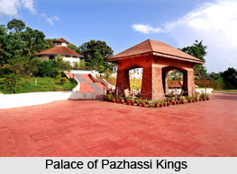
Pazhassi Revolt : While the British were busy with the political settlement of the district, Kerala Varma Pazhassi Raja of the Padinjare Kovilakom of the Kottayam family headed a serious revolt. The effective cause of the revolt was the unpopular revenue policy followed by the East India Company in Malabar. He stopped all collections of revenue in Kottayam. The Raja further threatened to cut down all the pepper vines if the Company`s officers continued revenue collection.
In April 1796, a determined effort was made by the British to capture the Raja in his own palace at Pazhassi. But the whole plan was in vain.
On December 18, the British Commissioner issued a declaration of frightening the people not to assemble or to assist the Pazhassi Raja. He also warned them that if they continue supporting him their property would be seized and would be regarded as enemy to the Government.
On December 30, an ineffective attempt was made to settle the differences between the Raja and the Company.
On 8th January 1797, Pazhassi Raja`s men attacked the havildar`s guard stationed at Pazhassi and the whole party was killed brutally except one man. The battle was fought on three successive days, 9th, 10th and 11th March 1797, the detachment made by the Company forces was overpowered by the swords, spears, bows and arrows of Pazhassi Raja`s men. As the situation was full of dangers, cooperation with the Pazhassi Raja became a matter of political feasibility.
In 1801 the effort of Colonel Stevenson`s cut off the pazhassi Raja from his followers in South Malabar. By May the British troops took every port both above and below the ghats in British hands and made the whole country disarmed. The Pazhassi Raja became a wanderer in the jungles accompanied by his wife and immediate attendants.
On May 24, 1804, Colonel Macleod issued a proclamation warning the people not to help the Pazhassi troops with arms, ammunition or provisions. Finally the proclamation of June 16 offered rewards for the apprehension of Pazhassi Raja, which told that their estates would be seized from that date.
On 1st November, Baber took direct charge of the operations and on November 30, 1805 he surrounded and shot the Ra.ja dead in an operation on the banks of a nullah. The Raja`s body was cremated with `customary honors`. With the death of Pazhassi Raja, the resistance movement in north Kerala came to an end.
Freedom Movement : Kannur District has played an important role in all the political movements of recent times. The Indian National Congress, which was founded in 1885, captured the attention of the people of this district. A district committee came into existence in Malabar in 1908. A branch of the All India Home Rule League, founded by Dr. Annie Beasant, functioned in Thalassery during this period.
During the independent movement the kannur district took an important part. The educational institutions in Kannur initiates the Non- Violent Non Co-operation movement as a means of achieving Swaraj, led to widespread boycott of foreign goods.
Mahatma Ghandhi and Maulana Shaukat Ali toured the district to carry the message of the Non-Co-operation and Khilaphat Movements. The Khilaphat movement equaled with the famous Malabar Rebellion of 1921 that was put down by the British with an iron hand.
Payyannur Conference : In the field of politics Kannur district came into the lime light in May 1920, when the fourth All Kerala Political Conference was held at Payyannur. This was organized under the support of the Kerala Provincial Congress. The said conference was presided over by Pandit Jawaharlal Nehru. The Payyannur Conference passed a resolution and requested the Indian National Congress to adopt `Complete Independence` instead of `Swaraj`.
Salt Sathyagraha : Payyannur was the main venue of the Salt Sathyagraha in Malabar. On April 13, a batch of Congress leader started on foot from Kozhikkode to the beaches of Payyannur and broke the salt laws there on Apri121. The Satyagraha camp at Payyannur was raided and the campers were beaten up.
The period following the withdrawal of the Civil Disobedience Movement witnessed the emergence of a radical wing in the Kerala Provincial Congress. Some of the radical elements in the Kerala Provincial Congress organized a Kerala unit of the Congress Socialist Party in 1934 and functioned as a separate group within the Provincial Congress. P. Krishna Pillai, A.K. Gopalan and E.M.S. Namboothiripad were the main leaders. An extremist group of Nationalist Muslims also emerged within the Congress when the leadership was done by Muhammad Abdur Rahman. The Congress Socialists and the Nationalist Muslims made common cause against the Ghandhian group known as the Right Wing, which was led by leaders namely K.Kelappan, C.K.Govindan Nair and K.A. Damodara Menon.
A notable development in the politics of Malabar during the thirties was the rise of the Muslim League as a district political party. It was the Muslim leaders of Kannur and Thalassery who played the lead role in forming this organization.
In late thirties the leftist elements in the Kerala Provincial Congress were also active in politics of Malabar. They took active part in organizing the workers, peasants, students and teachers of Kannur district under their banner. In the election held to the Kerala Provincial Congress Committee in January 1939, the Rightists suffered a severe set back. Muhammad Abdur Rahman was elected as the president of the K.P.C.C. and E.M.S. Namboothiripad as its general secretary. Towards the end of the same year, a branch of the Indian Communist Party was formally founded in Malabar. The Congress Socialist Party workers joined the Communist Party block.
Morazha Incident : The K.P.C.C. gave a call to the people of Malabar to observe September15, 1940 as Anti-Imperialist Day. But the Congress High Command disapproved the action. The whole day was spent by doing meetings and demonstrations. Kannur district was the center of this agitation. There were violent clashes between the people and the police at several places. To meet the situation the police applied Lathicharge and firing. Two young men were killed in a clash between a mob and a police party at Morazha.
The `Quit India` Movement of August 1942 also has its reference in Kannur district. A socialist group of workers under the leadership of Dr. K.B. Menon lead to the movement.
In 1945, at the end of the War, the Congress leaders were released from prison. By this time the Muslim League had become a decisive force in Malabar politics. It supported the demand of the All India Muslim League for the partition of India
Famine and Peasant Struggles : The district was devastated during the War period, especially from 1943 to 1945. Famine and cholera epidemic took thousands of lives from the lower strata of society. On the initiative of the people under the leadership of the Kisan Sabha, commendable services were rendered to tide over the crisis.
A new chapter of mass movement was organized by the Kisan Sabha, which was named as the `Grow More Food Campaign` at Mangattuparamba. More than fifty acres of government land was brought under cultivation. But the government suppressed the movement by force and destroyed the farm.
Though the War ended in 1945, famine continued to haunt the people. Karivellore, the northern most village of the present Kannur district, made a historic development in the struggle against poverty and famine. The transporting of paddy from Karivellore to Chirakkal Kovilakom was blocked and distributed to the people of the village. Leaders like A. V.Kunhambu and K.Krishnan Master led the movement.
 During the month of December 1946, the people of eastern village Kavumbayi raised their demand for "punam" cultivation. A strong police party was sent to the spot. The peasants resisted the armed forces, which led to the killing of five persons in the firing.
Another important phenomenon, which changed the course of the anti-imperialist movement, was the rise of the organized working class in the industrial sector. Regarding this in 1946 the struggle of Aron Mill workers is remarkable.
In the post independence era also the struggles of the peasantry formed an important part in the history of the State. They fought against landlords and their exploitation. Places like Thillankeri, Manayankunnu, Korom and Paddikkunnu are memorable in the annals of the peasant struggles.
In 1953, the All India Conference of Kisan Sabha decided to initiate struggles for new tenancy legislations at this district. The movement for Aikya Kerala that means united Kerala also got momentum during this period and all sections of the society rallied under the movement.
Geography of Kannur District
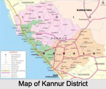
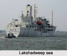
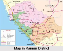 Kannur district is situated in the state of Kerala, bounded by the Western Ghats mountain range. It lies between the North latitudes of 11 degrees 40 minutes and 12 degrees 48 minutes and East longitudes of 74 degrees and 52 minutes and 76 degrees 7 minutes. The district is bounded by Coorg district in the east, Kozhikode district and Wayanad district in the South, Lakshwadeep Sea in the West and Kasaragod district, the northernmost district of Kerala, in the North. The district can be divided into three geographical regions - highlands, midlands and lowlands. The highland region comprises mainly of mountains. This is the area of major plantations like coffee, rubber, tea, cardamom and other spices. Timber trees like teak, veetty, etc are grown in plenty in this region. The midland region, lying between the mountains and the low lands, is made up of undulating hills and valleys. This is an area of intense agricultural activity. The lowland is comparatively narrow and comprises of rivers, deltas and seashore. This is a region of coconut and paddy cultivation.
The climate of the district is humid. It has an oppressive hot season from March to the end of May. This is followed by the South-West monsoon which continues till the end of September. October and November make up the post-monsoon or retreating monsoon season. The North-east monsoon which follows extends up to the end of February, although the rain generally ceases after December. During the months of April and May, the mean daily maximum temperature is about 35 degree Celsius.
Temperature is low in December and January -about 20 degrees Celsius. On certain days the night temperature may go down to 16 degree Celsius. The annual average rainfall is 3438 mm and more than 80 percent of it occurs during the period of South -West monsoon. The rainfall during July is very heavy and the district receives 68 per cent of the annual rainfall during this season.
Kannur district is very rich in vegetation. Natural vegetation, except in some coastal regions, consists of different types of forests. However in spite of the generally favourable climatic conditions, the vegetation is not uniform throughout the district. In restricted regions, which have their own micro climate or special formations, assume different characteristics. Thus a great variety of plants are found in the region ranging from psammophytes and mangroves to evergreen forests. The coastal region is a comparatively narrow zone, characterised by secondary soil which is rather loose and sandy. The serile sandy tract supports only a poor vegetation of the psammophyte type. Plants are few and mostly prostrate. Erect species are small and short. Owing to very poor water holding capacity of the soil, these plants are provided with special xerophytic adaptations. Another conspicuous feature of this area is the mangrove vegetation, found at the estuaries of rivers and backwaters, and often extending to the interior along their banks. Human interference has much changed the vegetation of the coastal region.
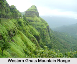
Major part of the district comes under midland region with numerous hills and dales and it presents an undulating surface gradually ascending and merging into the slopes of Western Ghats mountain range. Soil is secondary and lateritic with underlying rock of laterite or disintegrated greiss. The typical flora of this area is mostly deciduous forests, consisting of a mixture of evergreen and deciduous trees. Undergrowth consists of a variety of annuals and perennials. The mountains are a continuation of the midland region, gradually ascending to the main ridge of the Western Ghats. Soil in the western slopes is a ferrugenous red, sandy loam. Vegetation over the whole area is of the forest type. Irregular distribution of teak, localised areas of bamboo dominance, change of good quality forest into open grass lands, etc are characteristic features.
The geological formations in the district are of Archean and recent age. Archean formations comprise of greisses and charrockiates. Recent formations are alluvium and laterite. Archeans occupy the midland and highland regions of the district having rock types of basic charrockiates and hornblende-biotite greiss. The remaining portions in the coastal area are covered by laterite, alluvium, lignified woods, etc. Archean formations like foliated horn-blende-biotite greiss (gray or white in colour) is one of the main rock types in the northern portion of the district. Recent formations like laterite are developed on a limited scale along the coastal areas.
Administration of Kannur District
 Kannur district came into existence as an administrative unit on first January 1957, when the former Malabar district and Kasaragod taluk of Madras State were reconstituted into three revenue districts, namely, Kannur, Kozhikode and Palakkad town. At the time of its formation, the district consisted of seven taluks, viz, Kasaragod, Hosdurg, Thaliparamba, Kannur, Thalassery, North Wayanad and South Wayanad. Subsequently, the South Wayanad taluk was included in Kozhikode district with effect from 15th March 1957. Later, on first November 1980, Wayanad district was formed carving out South Wayanad and North Wayanad taluks. Two northern most taluks of Kannur district, viz; Kasaragod and Hosdurg were separated on 24th May 1984 for the formation of Kasaragod district.
Presently Kannur district has three taluks, viz., Kannur Thaliparamba and Thalassery. The taluks are subdivided into 129 villages.
Demography of Kannur District
Out of the total population of Kannur district, which is 2251727, 1098838 are males and 1152889 are females. A total of 1106251 comprise the rural population while 1145476 are the urban population.
Tourist places in Kannur District
Kannur is a beautiful district of the Indian state of Kerala. This district is surrounded by various wonderful places and there are also good place to visit within Kannur. Some of these are given here:
Sri Sundareswara Swamy Temple : This temple is dedicated to Lord Shiva. The annual festival of the temple is attended by a number of devotees.
Sri Krishna Temple : This temple is located at Kadalayi about 6 km from Kannur. It is dedicated to Lord Krishna. An eight day annual festival is celebrated here. Traditional art performances like the Kathakali, the Ottamthullal, etc., are performed during the festival.
Sri Jagannatha Temple : It is situated about 3 km from Thalassery. This temple is dedicated to Lord Siva. The famous reformer Sri Narayana Guru deity installed the deity here. An eight day festival is celebrated every year.
Malliyottu Kurumba Bhagavathy Temple : This temple is located at Kunjimangalam, 4 km from Payyanur. It is dedicated to Goddess Kurumba. A five day annual festival is very popular here.
Muchilottu Bhagavathy Temple : It is about 36 km from Kannur and is dedicated to Goddess Bhagavathy. It is situated at Kadanapally, Payyanur. The annual festival here lasts for 4 days.
Paralessery Temple : This temple is situated at Mundalur. Lord Muruga is the presiding deity here. He is the son of divine couple Lord Siva and Goddess Parvathy. The annual festival of this temple continues for eight days.
Sri Krishnaswamy Temple : This is an ancient temple, which attracts both the archaeologists and the layman. It is situated at Thrichambaram, 2 km from Thaliparamba. It is believed that Lord Parasurama installed the deity.
Sri Annapoorneswari Temple : It is situated about 14 km from Kannur. It is one of the temples where the grand Kerala architecture can be seen in its best form. The idols of Lord Krishna and Goddess Annapoorneswari are installed here. The annual festival here lasts for 14 days.
Kalarivathukkal Sri Bhagavathy Temple : It is situated at Chirakkal about 6 km from Kannur. This temple is dedicated to Goddess Bhadrakali, the Goddess of `bravery`.
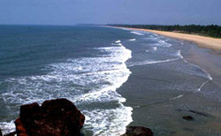 Payyambalam Beach : This is a beautiful beach and is the favourite destination of a number of visitors. It is situated about 2 km from Kannur.
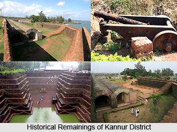
St. Angelo Fort : This beautiful fort is situated on the seaside. It is a 16th century monument of the Portuguese. This fort was erected in 1505 AD by Francisco De Almeda, the first Portuguese Viceroy to India. Now, the fort is under the care of Archaeological Survey of India. Mappila bay fishing harbour is an entertaining sight from the fort.
Arakkal Kettu : It used to be the residence of the Arakkal Ali Rajas, the only Muslim rulers of Kerala. It is situated about 3 km from Kannur.
Kizhunna Ezhara and Meenkunnu Beaches : These are situated about 11kms and 12 kms from the town respectively. These beaches attract huge number of tourists as well as locals for their beauty and solitude.
Parassinikadavu : It is situated about 16 km from Kannur. The charm of this place is added by the serene `Valapattanam River`. The famous Sri Muthappan temple is situated on the beautiful banks, which makes the place a popular pilgrim centre. Boating facility and accommodations are available. An entertaining snake park is situated nearby, with 3 snake pits, 15 glass cases and 2 glass houses exclusively for King Cobras. A fascinating variety of the reptile species are available here. Hourly snake shows are organized here. The visitors are allowed from 9:00 to 17:30 hrs.
Muzhapilangad Beach : This beach is situated about 15 km from Kannur. It has a stretch of about 4 km along the shallow waters, which is probably the only drive-in beach in Kerala. The clean waters here are the characteristic of this beautiful beach, which is well suited for swimming.
Gundert Bungalow : It is located 20 km from Kannur. It plays an important role in the recent bibliography of Malayalam, the language of the state. The great German missionary, scholar and lexicographer Dr. Herman Gundert had lived here for 20 years from 1839.
Thalassery Fort : This for was constructed around 1708. This grand fort served as the centre of military proceedings for the British. The Mosque, Jagannatha Temple; Sri Rama Temple and the Gym are the other tourist places near this fort.
Sri Ramaswamy Temple : This temple is dedicated to Lord Rama, the divine Hero of the great Hindu epic `The Ramayana`. Several magnificent carvings of centuries back can be seen here. It is situated 23 km from Kannur.
Madayi Para : Here, one can see a mosque here built in the 12th century by Malik Ibn Dinar. Even now, it shines with white marbles imported from Arabia, the birth place of Islam. The importance of this place was increased by the Madayi Kavu Temple and Vadakunnu Temple found here. Tipu Sultan is said have built this fort.
Malayala Kalagramam : It is situated at New Mahe, 29 km from Kannur. Painting, music, dance, sculpture, etc., are taught here.
Thodeekulam Siva Temple : As per the historical evidences, this ancient Shiva temple is said to have existed over 2000 years ago. The Pazhassi Raja family is said to have had close associations with this temple. It is situated about 34 km southeast of Kannur.
Pazhassi Dam : This dam is situated about 37 km on the East of Kannur. It has picturesque region around it with the beautiful `Pazhassi Dam`, which draws lots of tourists. This calm reservoir has the facility of boating for the visitors. The tourists can get accommodation in the project inspection bungalow and its dormitories.
Ezhimala : This wonderful place is situated about 55 km from Kannur. The magical beauty of the elephant beach and the extravagant hill of about 286 meter above the sea level make it a favourite tourist destination. Rare medicinal herbs with amazing curative property can be found here. The exquisitely carved stone pillars of ancient times developed here majestically from the ground at the hill foot. An ancient burial chamber can also be seen here. This is a restricted area and can be visited only after taking proper permission.
Pythal Mala : This is a hill resort, which is situated about 4,500 ft. above the sea level. It lies near the Kerala-Karnataka border. Several species of flora and fauna can be seen here. One needs to trek about 6 km on the challenging landscape to get to the top of the hills.
Aralam wildlife sanctuary : This is a fascinating sanctuary, which spreads over beautiful landscape of 55 sq. km. Elephants, bears, sambars, mouse deer and a number of other animals can be seen here.
Kottiyoor : The beautiful river Bavali flows here. An ancient famous temple dedicated to Lord Shiva is also found here. Every year, during the months of May-June, a long festival of 27 days is celebrated here.
Dharmadom : The small island of Dharmadom is situated about 3 km from Thalassery. It can be reached by bus from Thalassery. The place was earlier known as Dharmapattanam. It got the name from the popular belief that it was a Buddhist monastery as Buddha`s images are said to have been excavated from this place.
Sri Sundareswara Swamy Temple : This temple is dedicated to Lord Shiva. The annual festival of the temple is attended by a number of devotees.
Sri Krishna Temple : This temple is located at Kadalayi about 6 km from Kannur. It is dedicated to Lord Krishna. An eight day annual festival is celebrated here. Traditional art performances like the Kathakali, the Ottamthullal, etc., are performed during the festival.
Sri Jagannatha Temple : It is situated about 3 km from Thalassery. This temple is dedicated to Lord Siva. The famous reformer Sri Narayana Guru deity installed the deity here. An eight day festival is celebrated every year.
Malliyottu Kurumba Bhagavathy Temple : This temple is located at Kunjimangalam, 4 km from Payyanur. It is dedicated to Goddess Kurumba. A five day annual festival is very popular here.
Muchilottu Bhagavathy Temple : It is about 36 km from Kannur and is dedicated to Goddess Bhagavathy. It is situated at Kadanapally, Payyanur. The annual festival here lasts for 4 days.
Paralessery Temple : This temple is situated at Mundalur. Lord Muruga is the presiding deity here. He is the son of divine couple Lord Siva and Goddess Parvathy. The annual festival of this temple continues for eight days.
Sri Krishnaswamy Temple : This is an ancient temple, which attracts both the archaeologists and the layman. It is situated at Thrichambaram, 2 km from Thaliparamba. It is believed that Lord Parasurama installed the deity.
Sri Annapoorneswari Temple : It is situated about 14 km from Kannur. It is one of the temples where the grand Kerala architecture can be seen in its best form. The idols of Lord Krishna and Goddess Annapoorneswari are installed here. The annual festival here lasts for 14 days.
Kalarivathukkal Sri Bhagavathy Temple : It is situated at Chirakkal about 6 km from Kannur. This temple is dedicated to Goddess Bhadrakali, the Goddess of `bravery`.
Payyambalam Beach : This is a beautiful beach and is the favourite destination of a number of visitors. It is situated about 2 km from Kannur.
St. Angelo Fort : This beautiful fort is situated on the seaside. It is a 16th century monument of the Portuguese. This fort was erected in 1505 AD by Francisco De Almeda, the first Portuguese Viceroy to India. Now, the fort is under the care of Archaeological Survey of India. Mappila bay fishing harbour is an entertaining sight from the fort.
Arakkal Kettu : It used to be the residence of the Arakkal Ali Rajas, the only Muslim rulers of Kerala. It is situated about 3 km from Kannur.
Kizhunna Ezhara and Meenkunnu Beaches : These are situated about 11kms and 12 kms from the town respectively. These beaches attract huge number of tourists as well as locals for their beauty and solitude.
Parassinikadavu : It is situated about 16 km from Kannur. The charm of this place is added by the serene `Valapattanam River`. The famous Sri Muthappan temple is situated on the beautiful banks, which makes the place a popular pilgrim centre. Boating facility and accommodations are available. An entertaining snake park is situated nearby, with 3 snake pits, 15 glass cases and 2 glass houses exclusively for King Cobras. A fascinating variety of the reptile species are available here. Hourly snake shows are organized here. The visitors are allowed from 9:00 to 17:30 hrs.
Muzhapilangad Beach : This beach is situated about 15 km from Kannur. It has a stretch of about 4 km along the shallow waters, which is probably the only drive-in beach in Kerala. The clean waters here are the characteristic of this beautiful beach, which is well suited for swimming.
Gundert Bungalow : It is located 20 km from Kannur. It plays an important role in the recent bibliography of Malayalam, the language of the state. The great German missionary, scholar and lexicographer Dr. Herman Gundert had lived here for 20 years from 1839.
Thalassery Fort : This for was constructed around 1708. This grand fort served as the centre of military proceedings for the British. The Mosque, Jagannatha Temple; Sri Rama Temple and the Gym are the other tourist places near this fort.
Sri Ramaswamy Temple : This temple is dedicated to Lord Rama, the divine Hero of the great Hindu epic `The Ramayana`. Several magnificent carvings of centuries back can be seen here. It is situated 23 km from Kannur.
Madayi Para : Here, one can see a mosque here built in the 12th century by Malik Ibn Dinar. Even now, it shines with white marbles imported from Arabia, the birth place of Islam. The importance of this place was increased by the Madayi Kavu Temple and Vadakunnu Temple found here. Tipu Sultan is said have built this fort.
Malayala Kalagramam : It is situated at New Mahe, 29 km from Kannur. Painting, music, dance, sculpture, etc., are taught here.
Thodeekulam Siva Temple : As per the historical evidences, this ancient Shiva temple is said to have existed over 2000 years ago. The Pazhassi Raja family is said to have had close associations with this temple. It is situated about 34 km southeast of Kannur.
Pazhassi Dam : This dam is situated about 37 km on the East of Kannur. It has picturesque region around it with the beautiful `Pazhassi Dam`, which draws lots of tourists. This calm reservoir has the facility of boating for the visitors. The tourists can get accommodation in the project inspection bungalow and its dormitories.
Ezhimala : This wonderful place is situated about 55 km from Kannur. The magical beauty of the elephant beach and the extravagant hill of about 286 meter above the sea level make it a favourite tourist destination. Rare medicinal herbs with amazing curative property can be found here. The exquisitely carved stone pillars of ancient times developed here majestically from the ground at the hill foot. An ancient burial chamber can also be seen here. This is a restricted area and can be visited only after taking proper permission.
Pythal Mala : This is a hill resort, which is situated about 4,500 ft. above the sea level. It lies near the Kerala-Karnataka border. Several species of flora and fauna can be seen here. One needs to trek about 6 km on the challenging landscape to get to the top of the hills.
Aralam wildlife sanctuary : This is a fascinating sanctuary, which spreads over beautiful landscape of 55 sq. km. Elephants, bears, sambars, mouse deer and a number of other animals can be seen here.
Kottiyoor : The beautiful river Bavali flows here. An ancient famous temple dedicated to Lord Shiva is also found here. Every year, during the months of May-June, a long festival of 27 days is celebrated here.
Dharmadom : The small island of Dharmadom is situated about 3 km from Thalassery. It can be reached by bus from Thalassery. The place was earlier known as Dharmapattanam. It got the name from the popular belief that it was a Buddhist monastery as Buddha`s images are said to have been excavated from this place.
Recently updated articles in States of India

History of Thissur District
Early History of Thissur District explains flourishing of the port cities. Now these port cities are transformed into archaeological sites.

Tippi Orchid Research Centre, Arunachal Pradesh
Tippi Orchid Research Centre in Arunachal Pradesh is renowned for its rich collection of exotic and endangered orchids. Surrounded by lush rainforest...

Tourism in Nashik District
Pilgrimage tourism in Nashik district involves visiting the various places of Hindu and Jain worship located here. Some of the holiest sites for Hind...

Mangadu, Kerala
Mangadu in Kerala’s Kollam district is a significant megalithic site known for its urn burials, cist burials, menhirs, and stone circles. Excavations...

Devaswom
History of Devaswom is not very ancient and can be dated back to late seventeenth century.
Related articles in States of India

East Indian States
East Indian States comprises of Bihar, Jharkhand, West Bengal, Odisha and also the Union Territory of Andaman and Nicobar Islands. It defines the cult...

Purnia District in Bihar
Purnia District is located in Bihar and extends from River Ganga to Nepal. The district has a rich Hindu history and glorious past.

Hooghly district
Hooghly District along the bank of the river Hooghly is one of the principal trading ports of West Bengal.

Geography Of Chittoor District
Geography of Chittoor district is spread along the topography of the land which is divided into two natural divisions; Chittoor has a dry and healthy...

Districts of West Bihar
Districts of West Bihar is comprised of medieval monuments that were built by the different governors of Mughal era.