Introduction
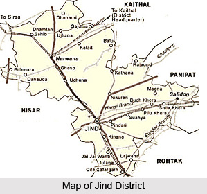 Jind District is one of the 21 administrative districts of Haryana. Jind town is the district headquarters. It is one of the oldest districts of Haryana and is one of the first Sikh Kingdoms. It lies in central region Haryana and is the fourth district of the Jat belt (includes Sonipat, Rohtak, Hisar and Jind). Jind town has Arjun stadium, milk plant, cattle feed plant and a large grain market. The town is well provided with schools, colleges, hospitals and other basic amenities. Other smaller towns of Jind District are Narwana, Safidon and Uchana. The total area of Jind district is 3606 sq kms and its total population as per 2001 Census is 11, 90,000.
Location of Jind District
Jind District lies between 29 degree 3 minutes and 29 degree 51 minutes north latitude and 75 degree 53 minutes and 76 degree 47 minutes east longitude. On its east and north-east lie the districts of Panipat, Karnal and Kaithal respectively. Its boundary line on the north forms the interstate Haryana- Punjab border with Patiala District and Sangrur district of Punjab. In its west and south-west it has a common boundary with district Hisar and Fatehabad and in its south and south-east it is surrounded by the districts of Rohtak and Sonipat respectively.
History of Jind District
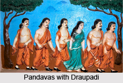 Ancient history says that the area in which Jind district lies formed an integral part of Kurukshetra in the traditional geographical account. It derived its name after Jainti, an ancient tirtha mentioned in Mahabharata and the Padma Purana, founded in honour of Jainti, the goddess of victory. According to a local tradition, Pandavas offered prayers to Goddess Jainti after their victory in the battle against the Kauravas. The antiquity of the district is established on the basis of the discovery of the Pre-Harappan, the Late-Harappan and the Painted Grey Ware pottery at various places from the district and the mention of its tirthas in the Puranas corroborates it.
According to the history of Jind District, the district was first occupied by a pre-Harappan agricultural community. History of this stage is not very clear and it is not yet possible to state from where these people had moved here or to throw much light on their socio-economic life. However, on the basis of the evidence of the nearby pre-Harappan sites like Mitathal (Bhiwani district), Siswal, Banwali and Rakhigarhi (Hisar district), it may be stated that these people possibly lived in mud brick and thatched roof houses, used wheel-made pottery, terracotta and copper-made objects.
Further, the classical Harappan site of Rakhigarhi (Hisar District) about 15 kms from Jind suggests the existence of such sites also in Jind district, but it lacks proper excavations. After the Harappans, the region was inhabited by the late-Harappans (1700 BC - 1300 BC) whose pottery has been recovered from many places in the district. Around 1000 BC, with the advent of the painted Grey Ware people, generally associated with the Aryans, a new era dawned upon this district. The people representing this new culture settled on the banks of the holy rivers Saraswati and Drishadvati, and the region came to be known as the holy land of Kurukshetra.
 The mention of various tirthas of Jind District in Mahabharata and the Puranas points to the continuance of activities of the Aryans here. The region came under the sway of the Vedic Bharatas, Purus and the Kurus and was included in the kingdom of Pandavas under whom it touched the height of glory. King Parikshit, had his second capital at Asandivat (Asandh in Karnal district), very close to Jind district. As per historical accounts, this area was also included in the kingdom of the Kurus, which was one of the sixteen Mahajanapadas in the 6th century BC mentioned in Buddhist literature. It was also a part of the Nanda Dynasty. After the fall of the Maurya Empire, the region witnessed the rise of several important republican people. In the ninth and tenth centuries AD, the district formed part of the Pratihara Empire whose inscriptions have been found at Sirsa, Pehowa and Delhi. Later on, the Tomaras, the feudatories of the Pratihara dynasty came to power here.
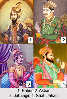
Medieval period of the history of Jind District suggests that after the demise of Shihab-ud-din Gauri, Qutub-ud-din Aibak established Turkish rule in northern India in 1206. The Haryana territory, including the present Jind district, formed a part of the Sultanate of Aibak. After the death of Firoz Shah Tughlaq (1388 AD), Jind District slipped out of the hands of the Tughlaqs. Lodis brought the district under their control in 1451 AD and retained it until 1526 when Babur, the founder of the Mughal Empire in India snatched it from Ibrahim Lodi.
Babur gave the entire Hisar division including Jind district to Humayun as a reward. Sher Shah Suri was an administrative genius. He divided his whole kingdom into sixty six sirkars. Jind came, as in the earlier time, under the Sirkar of Hisar. The administrative set-up during the reign of Akbar, Jahangir, and Shah Jahan underwent drastic changes after the death of Aurangzeb in 1707 which ushered in an era of chaos and confusion.
According to the modern history of Jind District, when India got its independence, the government merged Jind state with the newly created state of Patiala and East Punjab State Union (PEPSU) on July 15, 1948. With the formation of Patiala and East Punjab States Union (PEPSU) in 1948, the state was grouped into eight districts namely, Patiala District, Barnala, Bathinda District, Kapurthala District, Fatehgarh Sahib District, Sangrur District, Mahendragarh and Kohistan (Kandaghat). In 1953, the number of districts was reduced to five, by merging Barnala with Sangrur and Kandaghat and Fatehgarh Sahib with Patiala. Thus, Sangrur District comprised five tehsils, namely, Barnala, Malerkotla, Sangrur, Narwana and Jind.
Further, during the reorganisation of Punjab in 1966, Sangrur District was bifurcated and Jind and Narwana tehsils were allocated to Haryana and were constituted into Jind district. Jind tehsil was bifurcated into two tehsils of Jind and Safidon in 1967. In January 1973, 54 villages of Kaithal tehsil were transferred to Jind District, 43 going to Jind tehsil, 5 to Safidon tehsil and 6 to Narwana tehsil. One village namely, Barsola was transferred to Jind tehsil from Hansi tehsil of Hisar district in 1974.
Geography of Jind District
 Geography of Jind District includes the north-central part of Haryana. Physiographically, it constitutes a part of the Punjab-Haryana plain, which is largely flat and featureless and is formed of Pleistocene and sub-recent alluvial deposits of the Indo-Gangetic Plain. Jind district is located in a transitional zone between the sub-humid districts in the east and the semi-arid districts in the west. Geography of Jind District comprises a flat, monotonous upland plain. It is evident from the fact that the general elevation of the district ranges between 218 meters and 239 meters above sea level.
The climate of Jind District is on the whole dry, hot in summer and cold in winter. The year may be divided into four seasons. The cold season from November to March is followed by hot season which lasts till the onset of the south-west monsoon season. The monsoon season continues up to the mid of September and is followed by the Post-monsoon or the transition period. Average rainfall of Jind District as a whole is 55 cm. It generally increases from south or south-west to east or north-east. Over 70 per cent of the annual rainfall is received during the monsoon months of July to September. July and August are the rainiest months, together accounting for over 50 per cent of the annual rainfall. Per-monsoon rainfall in June constitutes just about 10 per cent of the annual normal. Some precipitation, constituting about 10 per cent of the annual rainfall, is also received during the winter months of December to February in association with western disturbances which pass across the district or its neighborhood from west to east, affecting the weather over the district in this season. The variation in annual rainfall from year to year is large.
From the beginning of March, temperature increases rapidly till June which is generally the warmest month. The mean daily maximum temperature during June is around 41 degree Celsius and the mean daily minimum around 27 degree Celsius. The heat in the summer season is intense. On individual days, the day temperature may occasionally exceed 47 degree or 48 degree Celsius. With the onset of the monsoon by the end of June or beginning of July there is a drop in the day temperature but the nights are nearly as warm as in June. Due to the increased humidity in the air, the weather is oppressive between the rains. After the monsoon season by the mid of September there is a decrease in temperature, the fall in the night temperature being more rapid. After October both day and night temperature decreases rapidly. January is usually the coldest month with the mean daily maximum temperature at about 21 degree Celsius, and the mean daily minimum temperature at about 6 degree Celsius in the winter season.
During the south-west monsoon-season of July to September, the relative humidity is high, being over 75 percent to 80 percent in the morning and 55 to 65 per cent in the afternoon. High humidity of more than 70 per cent also prevails during the winter months of December to February. It is comparatively drier during the rest of the year. April and May constitute the driest part of the year when in the afternoon the relative humidity is 20 per cent or even less. Moreover, the sky is moderately clouded mainly in July and August. Cloudiness decreases rapidly by October. From June onwards cloudiness increases. Winds are generally light. In the south-west monsoon season, winds from the south-west and west are more common. During the summer season, winds are from west or south-west in the morning. Thunderstorms, in association with pre-monsoon and monsoon rains occur mostly during June to September. During the winter season also, a few thunderstorms occur in association with the western disturbances.
There are minor undulations in the general physiographic formation of the district. These undulations characterise the area having been subject to wind action in the past and owe their existence to the presence of sand dunes, sand ridges and depressions at places. The sand dunes are now stable generally having a local relief of 2 to 6 meters. In brief, Jind District does not offer much physiographic diversity. It is flat, featureless, alluvial upland plain dotted only sporadically with sand dunes and depressions, yielding a local relief of not more than 6 metres either way. There is absence of any major stream or river in the district.
Jind District by and large is underlain by the quaternary alluvium comprising chiefly clays, sand of various grades, Kanker and occasionally gravel and pebbles. The soils of the Jind district are sandy and clayey. The area of Jind district is irrigated by two canal systems, Western Yamuna Canal and the Bhakra Canal. This district is not very rich in flora and there is no natural forest at present. Jind District is very poor as far as species of medicinal plants are concerned.
Administration of Jind District
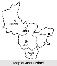
Administration of Jind District comprises three sub-divisions namely Jind, Narwana and Safidon. Jind sub-division is further divided into two tehsils - Jind and Julana. Narwana and Safidon sub-divisions comprise only one tehsil each, Narwana and Safidon respectively. Further, there are five Vidhan Sabha constituencies in this district - Julana, Safidon, Jind, Uchana Kalan and Narwana.
Education in Jind District
Before the middle of the 19th century only the indigenous system of education existed in the Jind District. No serious efforts were made by the princely state authorities till the close of 19th century when a few upper primary and vernacular middle schools were opened at Jind, Safidon and Narwana. These schools were later remodelled on Punjab educational system. There are several primary schools, secondary schools and degree colleges in Jind District.
Tourism in Jind District
 Tourism in Jind District includes visits to several places of historical and religious importance. The region comprising the Jind district formed boundary of the holy region of Kurukshetra and many holy places connected with tradition or referred to in religious literature are located in the district. Many of these places are mentioned in Mahabharata, Vamana Purana, Narada Purana and the Padma Purana.
Some of the noteworthy places of interest offered by Jind District are as follows -
Pilgrimage Tourism in Jind District : There are several legendary religious places in Jind District. Like for instance, there are many tirthas mentioned in the sacred old texts.
Some of them are mentioned below -
Asvini Kumara Tirtha: It lies at village Assan, 14 kms east of Jind and is associated with the Vedic twin deities Asvins. It is mentioned in Mahabharata, Padma, Narada and Vamana Puranas.
Varaha Tirtha: It is situated at around 10 kms from Jind. According to Vamana Purana, this well known tirtha was praised by Lord Vishnu. Padma Purana and Mahabharata inform say that it was the place of Vishnu who stayed here in his boar incarnation.
Ekahamsa Tirtha: It lies at village Ikkas, 5 kms south-west of Jind. According to a local tradition it is associated with Lord Krishna who concealed himself here.
Munjavata Tirtha: It lies at village Nirjan, 6 kms from Jind. The place according to Vamana Purana is associated with Lord Mahadeva.
Yakshini Tirtha: It is located in a village around 8 kms south of Jind. According to Vamana Purana it is located near Munjavata and is the place of Yakshini Mahagrahi.
Pushkara Tirtha: It is situated in village Ponkar Kheri, near about 11 kms south of Jind. According to Puranic traditions, Parasurama founded it. Another place of religious significance here is Kapila Mahayaksha.
Kayasodhana tirtha, Sri Tirtha, Sankhini tirtha, Arantuka tirtha, Dasasvamedha tirtha, Aruna tirtha, Panchanada tirtha and Koti tirtha are some of the other significant religious places located in Jind District.
Leisure Tourism in Jind District -
Apart from these places, there are several popular historical places in Jind District, which are described below -
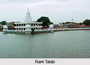
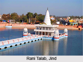
Jind: Jind is a historical place of the district and is noted for its numerous temples dedicated to Lord Shiva. Raghbir Singh, ruler of Jind, built a temple known as Bhuteshvara temple, with a large tank around it, locally known as `Rani Talab`. It has been renovated and a tourist complex has been built nearby. The other significant places of worship are the temples of Hari Kailash, tanks of Surya Kund, Jawala Maleshvara tirath. There is also a Gurudwara in the sacred memory of Guru Tegh Bahadur.
 Ramrai: Ramrai is an ancient village of Jind District. It is connected with the mythological story of Parasurama, incarnation of Vishnu . There is also an old temple of Parasurama here.
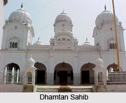
Dhamtan Sahib: It is situated about 10 km east of Narwana. It is said to be the ashram of Valmiki and venue of Ashvamedha Yagya of Lord Rama.
Safidon: This place is possibly the site of Sarpadevi referred in Mahabharata and Vamana Purana. This place is associated with several historical legends.
These places of tourist interest at Jind District attract travellers from far and wide and are worth seeing.


