Home > Travel > States of India > Geography of Ernakulum District
Geography of Ernakulum District
Many types of sands, soils and rocks that are of geological importance are found abundant in Ernakulum District.

Share this Article:

Geography of Ernakulum District, KeralaThe Ernakulum District has an area of 895.3Sq.k.m and can be divided geographically in to three well-defined parts such as Highland, Midland and Coastal area. The last one is also called as low land consisting of hills and forests, plains and the seaboard respectively. The altitude of Highland is about 1000 feet.

The borders of the district that is the four sides by which the district is surrounded are as follows: in the West the Arabian Sea, in the North Thrissur District, in the East Idukki District and in the South Alappuzha and Kottayam District. Periyar, which is Kerala`s second largest river, flows through all the Taluks except Muvattupuzha. Average rainfall of the district is 3431.8 mm, which is based on yearly basis and the total no of rainy days are 139. As there are rivers, lakes and seas the region has a moderate climate. Temperature is between 31.3oC and 25.8oC.

The hilly or Eastern portion is formed by a section of Western Ghats. We can define as Muvattupuzha, Kothamangalm and Aluva can be called the hilly taluks. The midland consists mainly of plain land having natural facilities of drainage via backwaters and canals. The Parur taluk which lies in the flat delta region of the Periyar river and cut by several canals, which have resulted in the formation of many islands and entire Kochi Taluk as well as the western part of Kanayannur come under lowland region. Major part of Kunnathunadu and eastern portion of Kanayannur taluk come under mid land region. It can be seen, as 20 percent of the total area is mainly low land region.Geography of Ernakulum District, Kerala

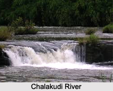
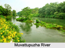
Thodupuzha, Muvattupuzha, Aluva, Kunnathunadu and Parur taluks. The Chalakudi River, which flows through north of Aluva, also joins Periyar at Elanthikara. The rivers Kaliyar, Thodupuzhayar and Kothamangalamar join together to form Muvattupuzha River. During rainy season these rivers are full and heavy floods affect the low-lying areas on the banks, but in the summer season they generally go dry and narrow. The Periyar is stretched over with a length of 229 Kms. The river plays a prominent role in the development of agriculture, industrial and commercial sectors of the district.

The seacoast in this district falls entirely in Kochi Taluk. One of the major natural Harbours is Kochi Harbour and is also situated in this taluk. Many Islands can be seen scattered in the backwaters in Kochi and Kanyannur Taluk. The Main islands of this district are Willingdon Island, Vypeen, Ramanthuruth, Cheriya kadamakkudi, Bolgatty The district has two main rivers Periyar and Muvattupuzha out of which the former flows through Ponjikara, Vallarpadam, Valiya Kadamakudi, Kumbalam, Panangad, Chellanam, Nettoor, Pizhala, Korampadam and Chennur. Most of these islands are very small in size extending from less than a 1 sq.km. To 4 sq.kms.

A portion of the Vembanad Lake falls within the Kochi Taluk. The Kodungalloor Kayal and Varappuzha kayal are also present in this district.


Share this Article:

Related Articles

More Articles in States of India


East Indian States
East Indian States comprises of Bihar, Jharkhand, West Bengal, Odisha and also the Union Territory of Andaman and Nicobar Islands. It defines the cultural heritage, rich historical background and the linguistic unity.
Erode District
Erode District is one of the districts in the state of Tamil Nadu. The district of Erode is having a land-locked area with no sea coast.
Purnia District in Bihar
Purnia District is located in Bihar and extends from River Ganga to Nepal. The district has a rich Hindu history and glorious past.
South Delhi District
South Delhi District is the third largest district of Delhi as far as its area is concerned. South Delhi District is known for its economic, historical, cultural and social significance.
North Indian States
North Indian States formed the cultural and religious unity in spite of having many foreign invasion and the political disturbances from the early era till the British gained supremacy in Indian sub continent.
Kendujhar District
Kendujhar District, spread over an area of 8,240 sq kms, is as varied as the whole of Orissa with waterfalls roaring gorges, mountains and minerals. The manifold expressions of nature in Kendujhar District are considered as unique.
Hooghly district
Hooghly District along the bank of the river Hooghly is one of the principal trading ports of West Bengal.
Districts of South Tamil Nadu
Districts of South Tamil Nadu consist of many tourism destinations like archaeological sites and the history of Pandyas and Cholas. Considering their proximity to the sea, many districts also boast of serene beaches and coastal beauty.
Flora of Arunachal Pradesh
Flora of Arunachal Pradesh includes infinite species and is a subject of great interests for the botanists.
Districts of South Gujarat
Districts of South Gujarat are the epicenter of Jain pilgrimages and the early Hindu kingdoms.
North West States of India
North West States of India consist of three states, which are Rajasthan, Punjab and Haryana. All of them are culturally and traditionally diverse and they have been ruled by different dynasties in historical time.
Geography Of Chittoor District
Geography of Chittoor district is spread along the topography of the land which is divided into two natural divisions; Chittoor has a dry and healthy climate.
Districts of North Rajasthan
District of Northern part of Rajasthan is dotted with ancient forts and medieval villages.
Districts of North Odisha
District of North Odisha has Bengal boundary and shares the same culture. These are reachable if one pays a weekend visit to Digha.
Districts of West Bihar
Districts of West Bihar is comprised of medieval monuments that were built by the different governors of Mughal era.
Districts of South Haryana
Districts of South Haryana consists of many cities of industrial excellence. These districts are dotted with popular tourism destinations.
Medieval History of Assam
Medieval history of Assam narrates the advent and rule of a number of kingdoms in the region. The prominent dynasties of the kingdom left an everlasting imprint on the socio cultural heritage of India.
Geography of Meghalaya
The suitable climate, highland plateaus, rivers and the flora and fauna together forms the geography of Meghalaya.
Districts of Rayalaseema
Districts of Rayalaseema in Andhra Pradesh state has urban population and rural settlements as well.
Districts of South Punjab
Districts of Southern part of Punjab depict medieval history of Punjab and the rise of Sikhs.