
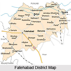
 Fatehabad District is one of the 21 administrative districts of Haryana and Fatehabad town is the district headquarters. Fatehabad District is surrounded by Punjab in the north, by Hisar District in the south, by Jind District in the east and by Rajasthan and Sirsa District in the west. Total geographical area of the district is 2520 sq kms which is around 5.4 percent of the total area of the state.
Fatehabad District
Fatehabad District is located in the south western part of Haryana. Fatehabad District has several big industries.
Introduction
Fatehabad District is one of the 21 administrative districts of Haryana and Fatehabad town is the district headquarters. Fatehabad District is surrounded by Punjab in the north, by Hisar District in the south, by Jind District in the east and by Rajasthan and Sirsa District in the west. Total geographical area of the district is 2520 sq kms which is around 5.4 percent of the total area of the state.History of Fatehabad District
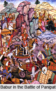 History of Fatehabad District narrates that with the decline of Mughal Empire, the tract comprising the present district came under the control of Marathas. The whole territory of Delhi, of which the tract formed part, was ceded by the Marathas to the British in 1810. The Delhi territory was divided into two districts, Delhi, directly under the resident and the outlying district including Hansi, Hisar, Sirsa, Rohtak, Panipat and Rewari under the immediate charge of an Assistant. Again in 1819, the territory of Delhi was divided into three districts namely the central district which included Delhi, southern district comprising Rewari and north-western district comprising Panipat, Hansi, Hisar, Sirsa and Rohtak.
Further, according to the history of Fatehabad District, in 1820 the north-western district was sub-divided into two separate districts, northern and western. The western district included Bhiwani, Hansi, Hisar and Sirsa and its headquarters were at Hansi. In 1824, Rohtak which had previously been under the western district was constituted into a separate district to which Bhiwani was transferred. The headquarters of the district was shifted from Hansi to Hisar in the year 1832. Moreover, the district was then divided into four tehsils of Hisar, Fatehabad, Hansi and Tosham. In 1837, Ratia and Tohana Parganas were added to Hisar District and were formed into a separate tehsil of Tohana. Sirsa tract was detached in 1837 from Hisar district and placed under a separate officer. Pargana of Darba and Pargana of Rori were transferred to Bhattiana in 1838 and 1847 respectively. In 1852, Pargana of Ratia was transferred from Tohana tehsil to Fatehabad tehsil and Barwala Pargana was detached from Hisar tehsil and was formed into a separate tehsil of Barwala along with Tohana.
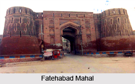
The whole of Delhi territory along with districts of Bhattiana and Hisar were transferred to Punjab in 1858 and the district of Bhattiana was re-named as Sirsa District. History of Fatehabad District also states that in 1861, Bhiwani tehsil was detached from Rohtak and added to Hisar District. Tosham tehsil was added to Bhiwani tehsil in the same year. On November, 1884, Sirsa tehsil with 199 villages and 126 villages of Dabwaii tehsil was added to Hisar District. In 1889, 15 villages were transferred from Kaithal tehsil to Fatehabad tehsil. Barwala tehsil containing 139 villages was abolished in the year 1891 and its area was distributed between three contiguous tehsils, 13 villages going to Hansi, 24 to Hisar and 102 to Fatehabad.
In 1923, the Tohana sub-tehsil was transferred from Fatehabad to Hisar tehsil. No transfer of territory to or from the district took place till the passing of the Provinces and States (Absorption of Enclaves) Order, 1950, by which the erstwhile princely state of Loharu was merged in the district and 15 villages were taken out of Hisar District and added to Bathinda District. In 1962, three villages were transferred from Dadri tehsil of Mahendragarh District to Bhiwani tehsil. Further, the entire area of the district was included in the new state of Haryana on November 1st, 1966. In 1968, Sirsa tehsil was bifurcated into Sirsa and Dabwali tehsil and Bhiwani was bifurcated into Bhiwani and Loharu. In 1969, a village was transferred from Dadri tehsil to Bhiwani tehsil.
These administrative arrangements continued till 1972 when whole of Loharu and Bhiwani tehsils, 32 villages of Hansi and 17 villages of Hisar tehsils were excluded and included in the newly formed Bhiwani District. Tohana sub tehsil was upgraded to a tehsil in 1972. In 1974, four villages were transferred from Hansi to Hisar tehsil, 18 villages from Hisar to Hansi tehsil, two villages from Hisar to Fatehabad tehsil, 18 villages from Tohana to Fatehabad tehsil, nine villages from Fatehabad to Tohana tehsil, 10 villages from Fatehabad to Hisar tehsil, 3 villages from Dabwali to Sirsa tehsil and one village from Hansi tehsil to Jind tehsil of Jind district. In 1975, Sirsa and Mandi Dabwali tehsils were excluded from the district and a new district of Sirsa was carved out. Thus, by the end of 1978, the Fatehabad part of Hisar district comprised 254 villages, divided between tehsils of Fatehabad 166, and Tohana 86. Fatehabad District came into existence in the year 1997 by carving out Hisar District.
Geography of Fatehabad District
 Geography of Fatehabad District comprises part of the alluvial or Ghaggar-Yamuna plain and its southern and western portions mark a gradual transition to Thar Desert in India. Geographic pattern of the district owes its existence to geomorphic processes having closer affinity with the climatic aridity, both of the recent and past geologic periods. Throughout almost the entire district the dominant feature of topography is the occurrence of Aeolian sand of variable shape and thickness overlying the Pleistocene alluvium which becomes fewer as the eastern border of the district is approached. The only variation from this description is found in the north, a tract locally known as Nali. The mean attitude varies between 210 metres and 220 metres and it generally slopes from north-east to south-west.
Fatehabad District can be sub-divided into three topographic units - Sub-Recent alluvial plain, Late Quaternary to Sub-Recent sand dune areas and Plain with sand dunes. The plain locally known as Nali occurs principally as floodplain sediments along the courses of the Ghaggar River. It is gently sloping, trending northeast to south-west in Tohana and Fatehabad tehsils. The sand dune areas can be classified into conspicuous topographic units having different genetic types of sand dunes such as active, semi-active and fossil or fixed. The active and moving sand dune generally occurs along the western fringe of Fatehabad District where the mean annual rainfall varies between 200 to 250 mm.
Active sand dunes vary from uneven sand cover, sand hummocks to small transverse dunes, some rising to about two metres above the surrounding surface. Of great geomorphic significance are the fossil or fixed dunes. They occur as broad features in long narrow chains but assume intersecting, forked, spiral and many other complex forms. Fossil dunes show larger concentration in south and south-east of Fatehabad. The dunes generally occur as transverse broad-based ridges possessing highly variable morphology. The plain with sand dunes is the largest topographic unit. It is the most important area of Fatehabad District covering the southern part of Tohana tehsil. Sand dunes and sand hills found scattered here and there in the plain give it a broadly undulating character.
Fatehabad District has a dry climate. The year may be divided into four seasons. The cold season from November to March is followed by the summer season which lasts up to the end of June. The period from July to the mid of September is the south-west monsoon season. The latter half of September and October constitute the post monsoon or transitional period. Average annual rainfall in the district is 395.6 mm. About 71 percent of the annual rainfall is received during the short south-west monsoon period, July and August being the rainiest months. The variation in the annual rainfall from year to year is very large. On an average there are 24 rainy days in a year. The mean daily temperature in May, which is the hottest month, is 41.6 degree Celsius. On individual days the maximum temperature during the summer season may rise up to around 47 degree Celsius or 48 degree Celsius. Decrease in temperature is rapid after October. January is generally the coldest month with the mean daily maximum at 21.7 degree Celsius and the mean daily minimum at around 5.5 degree Celsius. Relative humidity in the mornings is generally high during the monsoon season.
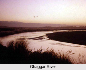
Geography of Fatehabad District also includes river system and water resources. Ghaggar, the largest seasonal stream in Haryana, enters the district as deeply incised alluvial channel and makes an exit little to the west of Fatehabad tehsil traversing around 70 kms. The river remains generally dry in summer. Hard rock geology of Fatehabad District is concealed under alluvial and Aeolian deposits. Kanker occurs at several places in the sandy tract of the district. It is used as a building material. The forests of Fatehabad District fall under the category of tropical desert thorn. Flora is scanty and sparse.
Administration of Fatehabad District
Fatehabad District has three sub-divisions namely Fatehabad, Tohana and Ratia. Further, administration of Fatehabad District has six development blocks - Fatehabad, Tohana, Ratia, Bhattu, Bhuna and Jakhal. There are 243 habited villages in the district. Tehsil Tohana and Bhattu Block of Fatehabad district is well connected by broad gauge railway line with Punjab, Delhi and district Sirsa. Road transport in Fatehabad District is well developed. National Highway No.10 connects Fatehabad with Delhi and Punjab.
Demography of Fatehabad District
Total population of Fatehabad District as per 2001 Census is 806158, of which male population is 427536 and female population is 379622. Further, according to Census 2001, total literacy rate of the district is 58.17 percent. Urban literacy rate is 76.15 percent and rural literacy rate is 56.75 percent.
Recently updated articles in States of India

Bandare Waterfalls, Meghalaya
Bandare Waterfalls in South Garo Hills, Meghalaya, is a secluded natural attraction surrounded by dense subtropical forests and rugged mountain terrai...

History of Thissur District
Early History of Thissur District explains flourishing of the port cities. Now these port cities are transformed into archaeological sites.

Tippi Orchid Research Centre, Arunachal Pradesh
Tippi Orchid Research Centre in Arunachal Pradesh is renowned for its rich collection of exotic and endangered orchids. Surrounded by lush rainforest...

Tourism in Nashik District
Pilgrimage tourism in Nashik district involves visiting the various places of Hindu and Jain worship located here. Some of the holiest sites for Hind...

Mangadu, Kerala
Mangadu in Kerala’s Kollam district is a significant megalithic site known for its urn burials, cist burials, menhirs, and stone circles. Excavations...
Related articles in States of India

East Indian States
East Indian States comprises of Bihar, Jharkhand, West Bengal, Odisha and also the Union Territory of Andaman and Nicobar Islands. It defines the cult...

Purnia District in Bihar
Purnia District is located in Bihar and extends from River Ganga to Nepal. The district has a rich Hindu history and glorious past.

Hooghly district
Hooghly District along the bank of the river Hooghly is one of the principal trading ports of West Bengal.

Geography Of Chittoor District
Geography of Chittoor district is spread along the topography of the land which is divided into two natural divisions; Chittoor has a dry and healthy...

Districts of West Bihar
Districts of West Bihar is comprised of medieval monuments that were built by the different governors of Mughal era.