Introduction
Districts of Mizoram bring forth the true culture and tradition of the state. Mizoram is a mountainous region which became the 23rd state of Indian Union in the year 1987. It was one of the districts of Assam till 1973 when it became a Union Territory. Mizoram consists of eight districts. Each district of Mizoram is administered by a Deputy Commissioner. A Deputy Commissioner holds several positions. Like for instance, he also acts as the District Magistrate as well as the District Collector. A Deputy Commissioner of a district of Mizoram is the executive head and he is responsible for maintaining law and order in the district. Deputy Commissioner is in charge for revenue collection in a district of Mizoram.
Districts of East Mizoram
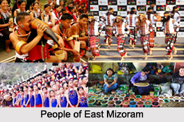 Districts of East Mizoram include Champhai district and Serchhip District. In these districts, one can find the tribal population. The Mizos are the original habitant here. The origin of the Mizos, like those of many other tribes in the North Eastern India is shrouded in mystery. They are generally accepted as part of a great Mongoloid wave of migration from China and later moved out to India to their present habitat. It is possible that the Mizos came from Shinlung or Chhinlungsan located on the banks of the river Yalung in China. They first settled in the Shan State and moved on to Kabaw Valley to Khampat now converted into a district and then to the Chin Hills in the middle of the 16th century. In 1959, Mizo Hills was devastated by a great famine known in Mizo history as `Mautam Famine". The cause of the famine was attributed to flowering of bamboos which consequently resulted in rat population boom in large numbers. After eating up bamboos seeds, the rats turned towards crops, infested the huts and houses, and became a plaque to the villages.
Champai District : Champhai District is one of the eight districts of Mizoram. The district is bounded on the north by Churachandpur district of Manipur state, on the west by Aizawl District and Serchhip district, and on the south and east by Myanmar. Champhai District occupies an area of 3185.83 square kilometers. Champhai town is the administrative headquarters of Champhai District.
Serchhip District : Serchhip District is one of the eight districts of Mizoram. Serchhip District occupies an area of 1421.60 square km. Serchhip town is the administrative headquarters of the district. Serchhip District came into existence on 15th September 1998, being carved out of the larger Aizawl District.
There are quite a number of places in East Mizoram. East Mizoram is the best place for sports tourism, adventure tourism and nature tourism. Blue Mountain is the highest peak in Mizoram. The Blue Mountain (Phawngpui) is situated in Chhimtuipui district overlooking the bend of the river Koldyne (Chhimtuipui) close on the state`s border with Myanmar. The peak, 2,157 meter in height and encircled by bamboo groves at the top where there is a level ground of about 200 hectares offers a grand view of the height hills and the meandering undulated valleys. The woods around are home to various species of beautiful and rare flora and fauna. Pukzing Cave is the largest cave in Mizoram. It is situated at Pukzing village near Marpara in the Aizawl district.
Districts of North Mizoram
 Districts of North Mizoram include Kolasib district, Mamit district and Aizwal District.
Kolasib District : Kolasib district is one of the eight districts of Mizoram state in India.
Mamit District : Mamit District, an administrative district of Mizoram, has four rural development blocks. The administrative headquarters of Mamit District is Mamit town.
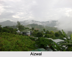
Aizawl District : Aizawl district is one of the eight districts of Mizoram state in India. The district is bounded on the north by Kolasib district, on the west by Mamit district, on the south by Serchhip district and on the east by Champhai district. Aizawl district occupies an area of 3,576.31 square kilometers. The headquarters of the district is Aizawl city, the capital of Mizoram. As of 2011, it is the most populous district of Mizoram. Aizawl is located north of the Tropic of Cancer in the northern part of Mizoram. It is situated on a ridge 1,132 metres above sea level, with the Tlawng river valley to its west and the Tuirial river valley to its east. Aizwal is thoroughly connected by flights from major cities like Kolkata, Imphal and Guwahati.
District of South Mizoram
 Districts of South Mizoram include the Siaha District, Lawngtlai district, and Lunglei district.
Saiha District : Siaha District is one of the eight districts of Mizoram. The district is bounded on the north and northwest by Lunglei district, on the west by Lawngtlai District and on the south and east by Myanmar. The district occupies an area of 1399.9 square kilometers. The Saiha town is the administrative headquarters of Siaha District. The population had decreased from 60,823 (in 2001 census) to 56,574. It is the least populous district of Mizoram. The majority of Siaha District inhabitants are Mara people, who also have an autonomous district council called Mara Autonomous District Council composed of the two R.D. Blocks of Saiha and Tuipang; the Lai people, on the other hand, are the main inhabitants of Sangau R.B block, which is part of the Lai Autonomous District Council.
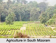
Lawngtlai District : Lawngtlai district is one of the eight districts of Mizoram state. The district is bounded on the north by Lunglei district, on the west by Bangladesh, on the south by Myanmar and on the east by Saiha district. The district occupies an area of 2557.10 square km. Lawngtlai town is the administrative headquarters of the district. The district shares its boundaries with Lunglei District and Saiha district on the north and south respectively. The inhabitants of Lawngtlai district are mainly the ethnic groups of tribals like Lai and Chakma, who are among the minor tribal communities of Mizoram. The main occupation is cultivation and the rural population largely depends on agriculture for their subsistence. The physical feature is mainly hilly except with long narrow strip of low-lying area along the western side of Chamdur Valley.
Lunglei District : Lunglei district is one of the eight districts of Mizoram state. As of 2011, it is the second most populous district in the state, after Aizawl. Lunglei district is bounded on the north by Mamit district and Aizawl district, on the west by Bangladesh, on the south by Lawngtlai district, on the southeast by Saiha district, on the east by Myanmar and on the northeast by Serchhip District. Lunglei district occupies an area of 4538 square km. Lunglei town is the administrative headquarters of the district. Lunglei district is named after its headquarters, Lunglei. It derived its name from a bridge like rock found in the riverine area around the Nghaish, a small tributary of the river Tlawng.