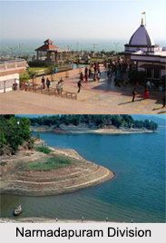
 Districts of Narmadapuram Division in Madhya Pradesh include Hoshangabad District, Harda District and Betul District.
Hoshangabad District
Hoshangabad District is one of the districts of Madhya Pradesh and Hoshangabad town is the district headquarters. Hoshangabad District lies in the Narmada River valley, and the Narmada forms the northern boundary of the district, Hoshangabad District is part of division. The Tawa River is a tributary of the Narmada, rising in the Satpura Mountain Range to the south and flowing north to meet the Narmada River at the village of Bandra Bhan. The Tawa Reservoir lies in the south-central region of the district.
Harda District
Harda District is a district of Madhya Pradesh state of central India. The town of Harda is the district headquarters. The district is part of Bhopal Division. Harda district was organized in 1998. Harda District has an area of 2644 square km, and a population 474,174 (2001 census), a 25% increase from 1991. Harda District is bounded by the districts of Sehore to the north, Hoshangabad to the northeast, Betul to the southeast, Khandwa to the south and west, and Dewas to the northwest. Harda District was created in 1998, when it was divided from Hoshangabad District. It is part of the Jabalpur Division of Madhya Pradesh.
Betul District
Betul District is a district of Madhya Pradesh state in central India. The city of Betul serves as its administrative headquarters. The district is a part of Narmadapuram Division. The climate of Betul District is healthy. Its height above the plains and the neighbourhood of extensive forests moderate the heat, and render the temperature pleasant throughout the greater part of the year. During the cold season the thermometer at night falls below the freezing point; little or no hot wind is felt before the end of April, and even then it ceases after sunset. The nights in the hot season are comparatively cooler and pleasant. During the monsoon, the climate is very damp and at times even cold and raw, thick clouds and mist envelops the sky for many days together. The average annual rainfall is 40 inches. Betul District is rich in tribal population. The tribal population of the district as per 2001 census is 5,49,907.


