Home > Travel > States of India > Bandipora District
Bandipora District
Bandipora district is a newly formed district in Jammu and Kashmir. This district has many tourists’ delights.

Share this Article:

Bandipora District, Jammu and KashmirBandipora district is one of the newly formed districts in Jammu and Kashmir. This district was carved out from the Bandipora town to administer the civil and the army system in this area.

Location of Bandipora District
Bandipora district is located very near to the Bandipora town. It is one of the 22 districts in Jammu and Kashmir State in northern India.

Naming of Bandipora
Bandipora is famous for three A`s - A`lim (knowledge), Adab (good habits or literature) and Aab (water). As can be known from the folklore, the name of Bandipora (pronounced as Band e-pur) originated either from Band of Wular Lake, due to the Bands of Place or due the Closed (Band in Kashmiri) geographical location.

Geography of Bandipora District
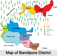
Bandipora district is bounded by Kupwara district in the west, Baramulla district in the south and Kargil, Srinagar District and Ganderbal district in the east.

Extension of Bandipora District
Bandipora district occupies an area of 398 square kilometres. The district has a population of 392,232 as per 2011 census.

Demography of Bandipora District
According to the 2011 population census, Bandipora district has a population of 385,099, roughly equal to the nation of Maldives. This gives it a ranking of 561st in India (out of a total of 640). The district has a population density of 1,117 inhabitants per square kilometre (2,890/sq mi).

Education of Bandipora District
According to its population growth rate, over the decade 2001-2011 was 26.31%. Bandipora District has a sex ratio of 911 females for every 1000 males, and a literacy rate of 57.82%.

Administration of Bandipora District
Bandipora town is the administrative headquarters of the district. This district was carved out from the erstwhile Baramulla district in 2007. The district comprises three tehsils: Bandipora, Sumbal Sonawari and Gurez. The district has three Vidhan Sabha constituencies: Gurez, Bandipora and Sonawari. All of these are part of Baramulla Lok Sabha constituency.

Tourism in Bandipora District
Bandipora District has the temples, lakes and the rivers as its tourist"s delights, which attracts not only the people of India, but also people all over world. The famous Lolab valley in Kupwara district is adjacent to the Bandipora District. It is just 30 km from Bandipora via Aaloosa village. Once this road is upgraded it will become a lifeline of the Lolab valley and it will provide an additional route to the Kupwara district. Danishwar, locally also called Chota Amar Nath is a cave in dense forests of Erin. Pilgrims have to crawl about 60 meters to reach a cave where there are engraved features of Lord Shiva or Mahadeva.

Related Articles
Jammu and Kashmir
Districts of Jammu and Kashmir
Culture of Jammu and Kashmir
Costumes of Jammu and Kashmir
Bandipora


Share this Article:

Related Articles

More Articles in States of India


East Indian States
East Indian States comprises of Bihar, Jharkhand, West Bengal, Odisha and also the Union Territory of Andaman and Nicobar Islands. It defines the cultural heritage, rich historical background and the linguistic unity.
Erode District
Erode District is one of the districts in the state of Tamil Nadu. The district of Erode is having a land-locked area with no sea coast.
Purnia District in Bihar
Purnia District is located in Bihar and extends from River Ganga to Nepal. The district has a rich Hindu history and glorious past.
South Delhi District
South Delhi District is the third largest district of Delhi as far as its area is concerned. South Delhi District is known for its economic, historical, cultural and social significance.
North Indian States
North Indian States formed the cultural and religious unity in spite of having many foreign invasion and the political disturbances from the early era till the British gained supremacy in Indian sub continent.
Kendujhar District
Kendujhar District, spread over an area of 8,240 sq kms, is as varied as the whole of Orissa with waterfalls roaring gorges, mountains and minerals. The manifold expressions of nature in Kendujhar District are considered as unique.
Hooghly district
Hooghly District along the bank of the river Hooghly is one of the principal trading ports of West Bengal.
Districts of South Tamil Nadu
Districts of South Tamil Nadu consist of many tourism destinations like archaeological sites and the history of Pandyas and Cholas. Considering their proximity to the sea, many districts also boast of serene beaches and coastal beauty.
Flora of Arunachal Pradesh
Flora of Arunachal Pradesh includes infinite species and is a subject of great interests for the botanists.
Districts of South Gujarat
Districts of South Gujarat are the epicenter of Jain pilgrimages and the early Hindu kingdoms.
North West States of India
North West States of India consist of three states, which are Rajasthan, Punjab and Haryana. All of them are culturally and traditionally diverse and they have been ruled by different dynasties in historical time.
Geography Of Chittoor District
Geography of Chittoor district is spread along the topography of the land which is divided into two natural divisions; Chittoor has a dry and healthy climate.
Districts of North Rajasthan
District of Northern part of Rajasthan is dotted with ancient forts and medieval villages.
Districts of North Odisha
District of North Odisha has Bengal boundary and shares the same culture. These are reachable if one pays a weekend visit to Digha.
Districts of West Bihar
Districts of West Bihar is comprised of medieval monuments that were built by the different governors of Mughal era.
Districts of South Haryana
Districts of South Haryana consists of many cities of industrial excellence. These districts are dotted with popular tourism destinations.
Medieval History of Assam
Medieval history of Assam narrates the advent and rule of a number of kingdoms in the region. The prominent dynasties of the kingdom left an everlasting imprint on the socio cultural heritage of India.
Geography of Meghalaya
The suitable climate, highland plateaus, rivers and the flora and fauna together forms the geography of Meghalaya.
Districts of Rayalaseema
Districts of Rayalaseema in Andhra Pradesh state has urban population and rural settlements as well.
Districts of South Punjab
Districts of Southern part of Punjab depict medieval history of Punjab and the rise of Sikhs.