 Totopara is a small hamlet in West Bengal located at a latitudinal limit of 89 minutes and 20 minutes east and 26 degree and 50 minutes north. This small hillock village is located in Alipurduar district of West Bengal.
Totopara in West Bengal is the home to the unique Toto tribes. For Toto tribes, this spot is known as Totopara. The village of Totopara is about 22 km from Madarihat. Madarihat is the entry point of the famous Jaldapara National Park, which is one of the prominent tourist site in northern hilly regions of West Bengal.
The administration of Totopara is under the district headquarters of Alipurduar District. This village falls under the Madarihat police station. Totopara in Alipurduar District is bounded by the foothills of Bhutan to the north, Torsa River to the east, and Titi river and the Titi Reserve Forest on the south-west of the village Totopara in West Bengal is separated by the Hauri river.
The nearest village of Totopara is Ballalguri. Ballalguri is about five kilometers to the south of Totopara. There is a single lane motorable road leading to this village of Totopara from the National Highway 31 through Hantapara. The area of the village is about 8.08 square kilometres.
In Totopara, there is a primary school, which was opened in the year 1990 to cater the children of the village in education. Since 1995, a high school with hostel facility was also opened to enhance the education of this small village of Toto tribe. There is one primary health centre in the village.
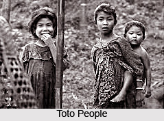 Totopara name comes from the Toto tribes. The majority people lived in Totapara belongs in Toto communities. Some Nepalese are also there but it is very minimum populous. The total area of Totapara is nearly 8 square kilometres, which is located on the fringe of Jaldapara Wildlife Sanctuary, one of the famous wildlife in Dooars and Southern area of the indo-Bhutan borderline.
There is Torsha River to the east. It divided into six Gram or Gaon (Villages) namely, Panchayatgaon, Mandolgaon, Subbagaon, Mitrang-gaon, Pujagaon and Dumchigaon. A primary school, a High School and a primary Health centre are there. A total numbers of 1184 (according with 2001 census) Totos live in nearly 200 houses in Totopara.
Toto tribal people believed in joint family system as like as other Indian communities people, but nuclear type family are also available. Monogamy is common form of marriage among the Toto but polygamy is not prohibited. Among the Toto tribal people, the love marriage is also acceptable. But divorce system is not accepted by them. A traditional Toto house builds with bamboo, straw and clay. These are hut with four folded roof make with straw, and all roofs are joined at the top elevation and declined towards the side wall.
Basically main foods of Totos are making with millet. Now a day, they are habituated with pure Bengali foods like- rice, carry of vegetables, dal, fish and meat. In each occasion they take a drink called Eu, toxic liquor. The tourist liquor "Eu" made from fermented marua, rice powder and malt. Eu is served warm in Poipa (wooden glasses).
Totopara in Alipurduar District of West Bengal is situated at the northern edges of the Jaldapara Wildlife Sanctuary. Jaldapara is well connected by road with Darjeeling, Siliguri and other towns of North Bengal. The nearest railway station to reach Totopara is Falakata, which is 19 kilometers from the sanctuary of Jaldapara. The nearest airport is Bagdogra. It is a domestic airport under Indian Army. All major air services are available from all over India.


