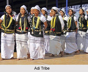
 Upper Siang district is an administrative district of Arunachal Pradesh. The district is a treasure house of natural beauty. It has 11 Administrative Circles. The district has a prominent inhabitation of Idu Mishmi, Khamba, Memba and Aditribes who dwell in this region since time immemorial. However, people of Adi tribe visibly dominate the district and they follow Donyi-Polo religion. People belonging to Memba tribe follow Tibetan Buddhism. The vibrant and colourful rituals and festivals of the district include Dihang, Lossar, Reh, Aran and Solung. The district is also known to be the fourth least populous district of India.
History of Upper Siang District
In ancient times, the district was a part of the independent Tibet and was called as Pemako. In the year 1999 the region gained its identity as an independent district after splitting up from East Siang district.
Geography of Upper Siang District
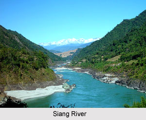
Upper Siang district is situated in the lap of nature with ravishing mountains having a variety of natural resources and a great biodiversity. Streams and rivulets meander gracefully through the place and form the tributaries of Siang River. Deep and wondrous gorges also adorn this beautiful district. It has a geographical area of 6188 square kilometres.
Demography of Upper Siang District
As per the census of 2011, the district has a population of 35,289 and ranks 637th in the country. The population density of the district is 5 persons per square kilometre. The population growth of the district has been recorded to be 5.77 percent. Sex ratio is 891 females per 1000 males. Upper Siang district has a literacy rate of 59.94 percent. Adi, which is a Sino-Tibetan dialect is the common language of the district and include about 140 000 speakers. It is written in both Latin and Tibetan.
Upper Siang district houses the famous Mouling National Park with an area of 483 square kilometres. Development of Upper Siang district has undergone major improvements. This seclusion and inaccessibility of the district have been the focus of the socio-economic developments and efforts have been made to improve the same. The headquarters of the district is situated at Yingkiong.


