Home > Travel > States of India > Chirang District
Chirang District
Chirang district is one of the twenty seven districts of the state of Assam. It is the second least populous district in the state according to the 2011 census.

Share this Article:

Chirang District, Assam
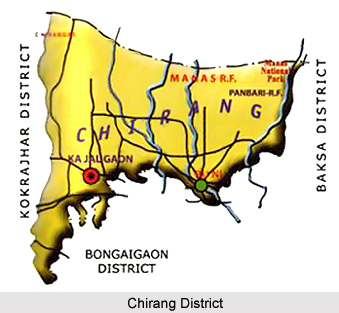
Chirang is relatively a new district of Assam. It has been carved out from Bongaigaon District, Kokrajhar, Bongaigaon and Barpeta districts in 2004. Kajalgaon is the district headquarters. The two Sub-Divisions in the district: Kajalgaon Sadar Sub-Division and Bijni Civil Sub-Division.

History of Chirang District
Chirang District is the new district in the BTC area of the state. Chirang district has been carved out from Bongaigaon district in the year 2004. The word "Chirang" has derived from Garo word -"Chi" means Water and "Rang" means wealth

. Geography of Chirang District
The Chirang district possesses a plain topography. It also has undulating areas and the northern parts of the district lie on the foothills of Bhutan that has slightly higher elevation, which is decreasing towards the southern parts of the district. The four types of soil found here are Entisols, Inceptisols, Alfisols and Ultisols. The district comes under Lower Brahmaputra Valley Agro-Climatic Zone. The climate is sub-tropical in nature with warm and humid summer followed by dry and cool winter. The pre and post-monsoon months are unpredictable and experience erratic rainfall. Champamati, Aie and Manas rivers flow through the district and join the Brahmaputra River. Many other tributaries, small rivulets and streams flow through this district.

Demography of Chirang District
According to the Population Census in 2011, the Chirang District had population of 481,818 of which male and female were 244,675 and 237,143 respectively. The population of Chirang District constituted 1.55 percent of total population of Assam. The population density of Chirang district is 244 people per sq. km. The average literacy rate of Chirang District was 64.71 %. If things are looked out at gender wise, male and female literacy were 71.35 % and 57.87 % respectively. The total literates in Chirang District were 266,380 of which male and female were 149,017 and 117,363 respectively.

Tourism in Chirang District
The following are the Tourist spots: Bongaigaon Refinery (IOCL), Champamati Mini Hydro-Electric Power Project, Kalamati(Orchid and Butterfly habitat), Ghumeswar Hills, Tukrabasti( picnic spot), Gabharukhunda(Biological Hotspot), Manas Tiger Reserve and Raja Charang Mandir in Basugaon.


Share this Article:

Related Articles

More Articles in States of India


East Indian States
East Indian States comprises of Bihar, Jharkhand, West Bengal, Odisha and also the Union Territory of Andaman and Nicobar Islands. It defines the cultural heritage, rich historical background and the linguistic unity.
Erode District
Erode District is one of the districts in the state of Tamil Nadu. The district of Erode is having a land-locked area with no sea coast.
Purnia District in Bihar
Purnia District is located in Bihar and extends from River Ganga to Nepal. The district has a rich Hindu history and glorious past.
South Delhi District
South Delhi District is the third largest district of Delhi as far as its area is concerned. South Delhi District is known for its economic, historical, cultural and social significance.
North Indian States
North Indian States formed the cultural and religious unity in spite of having many foreign invasion and the political disturbances from the early era till the British gained supremacy in Indian sub continent.
Kendujhar District
Kendujhar District, spread over an area of 8,240 sq kms, is as varied as the whole of Orissa with waterfalls roaring gorges, mountains and minerals. The manifold expressions of nature in Kendujhar District are considered as unique.
Hooghly district
Hooghly District along the bank of the river Hooghly is one of the principal trading ports of West Bengal.
Districts of South Tamil Nadu
Districts of South Tamil Nadu consist of many tourism destinations like archaeological sites and the history of Pandyas and Cholas. Considering their proximity to the sea, many districts also boast of serene beaches and coastal beauty.
Flora of Arunachal Pradesh
Flora of Arunachal Pradesh includes infinite species and is a subject of great interests for the botanists.
Districts of South Gujarat
Districts of South Gujarat are the epicenter of Jain pilgrimages and the early Hindu kingdoms.
North West States of India
North West States of India consist of three states, which are Rajasthan, Punjab and Haryana. All of them are culturally and traditionally diverse and they have been ruled by different dynasties in historical time.
Geography Of Chittoor District
Geography of Chittoor district is spread along the topography of the land which is divided into two natural divisions; Chittoor has a dry and healthy climate.
Districts of North Rajasthan
District of Northern part of Rajasthan is dotted with ancient forts and medieval villages.
Districts of North Odisha
District of North Odisha has Bengal boundary and shares the same culture. These are reachable if one pays a weekend visit to Digha.
Districts of West Bihar
Districts of West Bihar is comprised of medieval monuments that were built by the different governors of Mughal era.
Districts of South Haryana
Districts of South Haryana consists of many cities of industrial excellence. These districts are dotted with popular tourism destinations.
Medieval History of Assam
Medieval history of Assam narrates the advent and rule of a number of kingdoms in the region. The prominent dynasties of the kingdom left an everlasting imprint on the socio cultural heritage of India.
Geography of Meghalaya
The suitable climate, highland plateaus, rivers and the flora and fauna together forms the geography of Meghalaya.
Districts of Rayalaseema
Districts of Rayalaseema in Andhra Pradesh state has urban population and rural settlements as well.
Districts of South Punjab
Districts of Southern part of Punjab depict medieval history of Punjab and the rise of Sikhs.