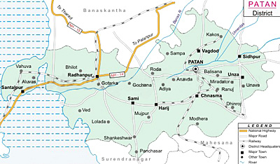
 Patan district is located in northern Gujarat. The district is spread across seven talukas, viz. Santalpur, Patan, Chanasma, Harij, Sami, Radhanpur and Sidhpur. The region is famous for Patola sarees. Key raw materials such as cotton, fennel, isabgul, and cowpea are abundantly available in the district. The total area of the district is 5, 667.55 sq. km. As per 2001 census the population of this district is 11, 82,709 with a population density of 209 persons per sq. km.
Geography of Patan District
Geographical location of Patan is 23.55 degree to 24.41 degree North (Latitude) and 71.31 degree to 72.20 degree East (Longitude). The maximum temperature of Patan district is 45 degree centigrade and the minimum temperature is 7 degree centigrade. Average rainfall in this district is 600 mm. Saraswati River is the main river in this district.
Education in Patan District
There are 786 primary schools and 171 secondary and higher secondary schools at Patan district. The district houses some of the renowned technical and law colleges. The district also has the provision for distance learning programs and correspondence courses offered by various Study Centers under Open University Scheme of Indian universities. The Government Engineering College and K.D. Polytechnic College at Patan offers courses in computer science, electronics and communications and mechanical engineering.
Economy of Patan District
 Economy of Patan district is mainly agrarian. Food processing, agriculture, and textiles are the major vocational and industrial activities in Patan. The Food Processing Industry of Patan is well developed because of the proximity to agricultural districts such as Mehsana, Banaskantha etc. Textile sector also contributes largely to the district economy. Patan Patola is one of the finest hand woven textile materials produced. There are 4,641 small scale industries in Patan district.
Tourism in Patan District
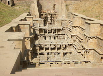
Patan district has various tourist attractions. The Queen`s Step well or Rani Ki Vav is one of the most magnificent step wells of Gujarat built during 11-12th century. The Sahastralinga Talav or tank of a thousand Shiva shrines is an exotic piece of art. The district has more than hundred Jain temples, among which the one dedicated to Panchasara Parasvanath is the largest and has intricate stone carvings and white marble floors that characterise Jain architecture.
How to reach Patan District
By Air:
The nearest airport Ahmedabad is located at a distance of 125 km from Patan district.
By Road:
National Highway 14, 15 and State Highway 7, 8 and 10 run through the Patan district connecting it with major cities of the state and the rest of India. It is well connected with Ahmedabad (125 km), Banaskantha (58 km) and Kutch (318 km).
By Rail:
Western railways connect Patan with major cities in India such as Delhi and Mumbai via Ahmedabad.


