Introduction
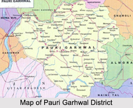 Pauri Garhwal District is an administrative district in the north Indian state of Uttarakhand. Pauri city which is situated at an altitude of 1814 metres above the sea-level on the northern slopes of Kandoliya hills is the headquarters of the district and the Garhwal Division. The headquarters of all government departments are located in Pauri.
Location of Pauri Garhwal District
Pauri Garhwal District is surrounded by Chamoli District, Rudraprayag District and Tehri Garhwal District in the north, Bijnor and Udham Singh Nagar District in the south, Almora District and Nainital District in the east, Dehradun and Haridwar in the west.
History of Pauri Garhwal District
History of Pauri Garhwal District suggests that through the ages, the evolution of human civilization in this region of Garhwal Himalaya has been parallel to the rest of Indian sub-continent. Katyuri was the first historical dynasty, which ruled over unified Uttarakhand and left some important records in the form of inscriptions and temples. In the later period after the downfall of the Katyuris, it is believed that the Garhwal region was fragmented in more than sixty-four principalities ruled by a chieftain, one of the principal chieftainship was Chandpurgarh. In the mid of 15th century A.D. Chandpurgarh emerged as a powerful principality under the rule of King Jagatpal (1455 A.D to 1493 A.D.), who was a descendent of Kanakpal. Towards the end of 15th century AD King Ajaypal enthroned Chandpurgarh and ruled the region. Subsequently, his kingdom came to be known as Garhwal and he transferred his capital from Chandpur to Devalgarh before 1506 AD and later on to Srinagar during 1506 to 1519 A.D.
King Ajaypal and his successors ruled the region of Garhwal for nearly three hundred years even during this period they had faced a number of attacks from Kumaon, Mughals, Sikhs and Rohillas. An important event in the history of Pauri Garhwal District was Gorkha invasion. It was marked by extreme brutality. After conquering Doti and Kumaon, Gorkhas attacked Garhwal despite stiff resistance put up by the Garhwali forces. But in the meantime, news came of a Chinese invasion and the Gorkhas were forced to lift the siege. However, in 1803, they again mounted an invasion. After capturing Kumaon, they attacked Garhwal in three columns. Eventually, the Gorkhas became the masters of entire Garhwal in 1804 and ruled the territory for twelve years.
The rule of Gorkhas in Garhwal area ended in 1815 after the British invasion in the region. After the defeat of Gorkha army, the British rulers on 21st April 1815, decided to establish their rule over the eastern, half of Garhwal region, which lies east of Alaknanda River and Mandakini river. The remaining part of Garhwal in the west was restored to King Sudarshan Shah who established his capital at Tehri. Initially the administration was entrusted to the commissioner of Kumaon and Garhwal with headquarters at Nainital, but later Garhwal was separated and formed into a separate district in the year 1840 under an assistant commissioner with his headquarter at Pauri. In early 1960, Pauri Garhwal District and Chamoli District was curved out of Garhwal district.
Geography of Pauri Garhwal District
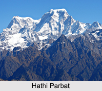
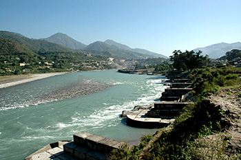 Geography of Pauri Garhwal District is by and large rugged and except for the narrow strip of Bhabar, the entire region is mountainous. The highest point of the area is 3116 metres at Doodhatoli and the lowest point of the area is 295 metres near Chilla. The cross profiles of the fluvial valleys show convex form with steep valley sides, interlocking spurs descending towards the main channel, hanging valleys, water falls and rapids and terraced agricultural fields on the gentle slopes on the valley sides. The clustering of villages is confined mainly on the gentle slopes of the ridges on the fluvial terraces. The forest cover is the maximum in Thailisain block and the minimum in the Pauri block. Most of the part of the area is easily approachable.
Pauri Garhwal District has a sub-temperate to temperate climate, which remains pleasant throughout the year. The maximum temperature recorded in the month of June is 45 degree Celsius at Kotdwara while in the higher reaches at Doodhatoli it only rises to 25 degree Celsius. Temperature descends to a minimum of 1.3 degree Celsius in January and mean monthly temperature for the region ranges from 25 degree Celsius to 30 degree Celsius. The hilly terrain of the district with its densely forested slopes receives adequate rainfall generally commencing from mid-June and extending till mid-September. Occasional rainfall is also recorded in winter. Average annual rainfall in the district is 218 cm, about 90 percent of which is generally concentrated over the monsoon. Relative humidity varies between 54 percent and 63 percent. The higher reaches receive some snow in winter when temperature falls to freezing point.
Pauri Garhwal District as part of the Western Himalayas presents a unique set of ecological characteristics over a complex variety of systems that incorporate forests, meadows, savannah grasslands, marshes and rivers, as well as wildlife, geology and several other phyto-geographically distinctive peculiarities. The occurrence of diverse topographical and climatic factors has resulted in the remarkable biodiversity of Pauri Garhwal District as a result of which flora also correspondingly differs over its different parts. Forests dominate in the phyto-geography and also constitute the most valuable natural resource of the district. Besides Alaknanda River, Nayyar River is the other major river of the district and is one of the major tributaries of Alaknanda. Soils of the region have been formed either through pedo-genetic processes or are transported soils.
Demography of Pauri Garhwal District
According to the Population Census in the year 2011, the total population of Pauri Garhwal District is 6, 97,078 with male population of 3, 31,061 and female population of 3, 66,017. The majority of the population lives in villages as indicated by the rural population of 6, 07,203.
Administration of Pauri Garhwal District
 Pauri Garhwal District is administratively divided into nine tehsils, namely Pauri, Lansdown, Kotdwar, Thalisain, Dhumakot, Srinagar, Satpuli, Dhumakot and Yamkeshwar. There are 15 developmental blocks, and these are Kot, Kaljikhal, Pauri, Pabo, Thalisain, Bironkhal, Dwarikhal, Dugadda, Jaihrikhal, Ekeshwer, Rikhnikhal, Yamkeswar, Nainidanda, Pokhra and Khirsu.
Culture of Pauri Garhwal District
 The folk songs, folk music and folk dances form the colourful and vibrant culture of Pauri Garhwal District and reflect its traditional cultural richness. As the life of the people of this district of Uttarakhand is closely associated with nature and religion, the folk activities are closely associated with these features in representation of the inherent customs and traditions of the people. Folk songs of Pauri Garhwal District reflect a basic simplicity and uncomplicated emotions, largely derived from the environment of peace, tranquility and the open nature all around. The themes of songs are understandably linked with various agricultural activities and their love for the land. Moreover, certain socio-economic problems figure in the folk songs of the region as well. It includes problems like floods, droughts and ill treatment of the people. Some of the popular folk songs narrate stories of bravery and legends.
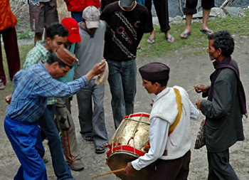
The tradition of folk songs is much alive in the rural areas of Puri Garhwal District. In villages, women sing these folk songs while working in the fields or collecting fodder in forests. There are many styles of group singing, sometimes, accompanied by rhythmic dances. These include "Jhoda" and "Thadya". "Khuded" songs echo the sad feeling of young bride, who is leaving her paternal home. "Mandals" songs are usually sung on the occasion of marriage, thread ceremony and other "sanskars". On the other hand, "Panwaras" songs are composed to record heroic deeds and sung in praise of worriers.
Culture of Pauri Garhwal District also includes various forms of folk dances. Folk dances of the region are mainly for entertainment, recreation and praising the local Gods. Generally, these are performed in groups. Some dances are accompanied by folk songs and they carry the same name. These folk dances are mainly influenced by the devotional attachment of the people and the association of Pandavas with the region of Garhwal Himalaya. In religious folk dances, the dance of `Pashwa`, a person carrying local God`s spiritual traces, on the `Jagar` songs are most common. `Jagari` directs these dances and `Pashwa` (the dancer) dances as per the `Varta` (the story songs) of the particular God or Goddess. `Pandava dances` are based on the story of Pandavas in Mahabharata and these are group dances played to the rhythm of musical instruments in an open ground. Further, the folk dances of the district also represent the rich social traditions and joys of the life. `Thadiya`, `Chauffulla`, `Sarron`, `Chepli`, etc. are some of the popular folk dances of the region. `Thadiya` dance is generally performed in fairs and festivals, in which the dancers are divided in two groups. `Chauffulla` dance has a distinguished place amongst all the Garhwali dances. `Chauffulla` means `blossoming of flowers all around`.
The folk music of this district is generally rhythmic which is reflected in the dynamic style of folk dances. Songs related to `Sansakaras` and seasons are melodious and the rest are musical as they are played on the rhythm of the musical instruments. Some of the very popular traditional folk musical instruments of this area are `Dhol and Damoun`, `Daur and Thali`, `Turri`, `Ransingha`, `Dholki`, `Masakbhaja`, `Bhankora`, etc. These arethe main folk musical instruments of the area and are played on most of the occasions.
Archaeological Sites in Pauri Garhwal District
 Archaeological sites in Pauri Garhwal district, Uttarakhand, unfold the ancient cultural heritage of the region. A number of old temples grace the place revealing the cultural beliefs and magnificent architecture that prevailed in the bygone era. Rock inscriptions have also been found at the temples which further reveal several historical facts. Apart from these, numerous ruins and mounds have also been discovered in this region. These archaeological sites also form a popular tourist sites and attract a number of tourists from far off regions to explore the ancient history of Pauri Garhwal district.
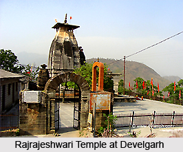
Develgarh
Develgarh is situated near the town of Srinagar. The place was founded by the King of Kangra, known as Devel. The major attractions of Develgarh include Rajrajeshwari temple, Gauri Devi temple and Laxmi Narayan temple. A number of inscriptions have been found on the stones of the temples. The Laxmi-Narayan temple houses `Sthanaka` (standing) Vishnu sculpture. The decorative motifs and the artistry of the temple suggest that they belong to 9th-10th century A.D.
Shankar Math
Shankar Math is located at a distance of about 3 kilometres from the town of Srinagar. Adi Guru Shankaracharya is believed to have established this temple. The architectural beauty of Shankar Math is immensely admirable. Stone idols of Goddess Lakshmi and Lord Vishnu are found in the Garbhagriha or the sanctum of the temple. The artistic features of the temple signify that its origin is enrooted in 17th century.
 Keshori Math
Keshori Math is another important archaeological site known for its exquisite architecture. Huge stones form the structure of this temple. On the stone of the main entrance, inscriptions belonging to 1682 A.D. have been found which say that the temple was erected by a person named `Keshorai`.
Binsar Mahadev
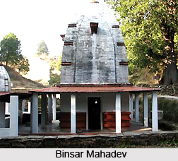
Binsar Mahadev is another ancient temple which stands at an altitude of 2480 metres. The temple was built in the honour of Lord Shiva and holds much archaeological significance. The Garbhagriha or the sanctum houses idols of Maheshmardini, Har Gauri and Lord Ganesha. Inscriptions in `Nagri lipi` have been found engraved in the idol of Maheshmardini which suggests that it belongs to 9th century.
Kanda
The temples of Kanda are located near Delchauri village, at a distance of about 44 kilometres from the district headquarters of Pauri Garhwal. Bhagwati temple stands in this place, the sanctum of which hosts idols of Vishnu (12th - 13th century), Surya (10th- 11tt century), Uma-Mahesh (11th-12thcentury) and Lakshmi-Narayan (12th century). Apart from these, many other images of other deities have also been discovered which makes the place archaeologically important.
Deval
Deval group of temples are located in Sitansu Patti of Pauri tehsil. It is also known as Vashnav temples. Twelve temples constitute this group which are categorized into two groups on the basis of time period. The first group of temples comprise of Shiva and Lakshman temples of 18th to 19th century. The other group is more ancient than the first group and belong to 11th to 15th century.
Laldhang
Laldhang is located in Kotdwar tehsil of Pauri Garhwal district. In the main market a Shiva temple stands. In the sanctum of this temple an idol of Panchyatan Shivling is installed which was brought from Panduwala. Surrounding the Panchyatan Shivlig images of Uma-Mahesh, Surya, Vishnu and Bramha are engraved. The main idol belongs to 9th century. Apart from this, ruins of temples and ponds along with remains of pre and post medieval era earthenware have also been found.
Tourism in Tehri Garhwal District
 Tourism in Pauri Garhwal District includes a number of exploring options. Tourism in Pauri Garhwal District has developed tremendously making it one of the most popular tourist destinations of the country. Pauri Garhwal District is considered as nature`s paradise and it attracts people through its charm and magnificence. The beautiful valleys, snow clad mountain peaks and the amazing vies of the nature are the key components that attract the travellers. Moreover, tourism in Pauri Garhwal District will be considered incomplete without paying a visit to its ancient temples. Some of the main places of interest in this district of Uttarakhand are as follows.
Khirsu: The snow covered mountains of Khirsu offer a panoramic view of the Central Himalayas and attract a large number of tourists. From here one can get a clear view of many named and unnamed beautiful peaks. Located 19 kms away from Pauri at an altitude of 1,700 metres, Khirsu is a peaceful spot, free from any hustle and bustle. Only the chirping of birds breaks the tranquility of the adjoining thick Oak and Deodar forests and apple orchards. The ancient temple of Ghandiyal Devta in the vicinity is well worth a visit.
Doodhatoli: Doodhatoli situated at an altitude of 3100 metres, is covered with dense mixed forests. One of the most picturesque places, it commands a panoramic view of the Himalayan ranges and the surrounding area.
 Binsar: Binsar is situated at an altitude of 2480 metres and is at a distance of 114 kms from Pauri. Set amidst dense forests of Oak, Deodar and Rhododendron, it is a celebrated place of worship and natural beauty. The temple dedicated to Lord Shiva is of archaeological significance.
Adwani: Connected by a well-maintained 17 kms long road from Pauri, Adwani is an ideal picnic spot, as it is surrounded by thick forest and is devoid of the hustle and bustle of the town.
Tara Kund: Situated at a height of 2,200 metres, Tara Kund is a picturesque spot amidst lofty mountains. A small lake and an ancient temple adorn the place. Teej Festival is celebrated here with great gaiety and enthusiasm.
Kandoliya: At a distance of 2 kms from Pauri, Kandoliya is a spectacular spot surrounded by dense forest. The temple of Kandoliya Devta, the local `Bhumi-Devta`, is located here. One can have a panoramic view of Himalayan peaks and Gangwarsyun valley. One can have a walk along 4 kms long road from Kandoliya to Buwakhal through oak and pine forest that is really refreshing.
 Kanvashram: Situated on the bank of river Malini at a distance of 14 kms from Kotdwara, Kanva Rishi Ashram is an important place from the historical and archaeological point of view. It is believed that Sage Vishwamitra meditated here.
Bharat Nagar: 22 kms away from Kotdwara and at a height of 1,400 metres, Bharat Nagar abounds in immense natural beauty. It is mentioned in the ancient Hindu texts that once this place was full of medicinal herbs. From here one can have a beautiful view of the Balawali bridge of Ganga, Kalagarh dam and Kotdwara town.
Kalagarh: Situated at a distance of 48 kms from Kotdwara, Kalagarh is an ideal place for nature lovers. The dam across Ram Ganga River is also worth visiting.
Neelkanth: As the name suggest this place is dedicated to Lord Shiva. It is believed that this is the place where Lord Shiva consumed venom which emanated during the Samudra Manthan. This place is 32 kms from Rishikesh and has a great religious, mythological significance among the devotees. The place is surrounded by the dense forest of Oak and Deodar and offers a panoramic view of the nature.
Chilla Wildlife Sanctuary: Chilla Wildlife Sanctuary, a heaven for animal watchers is just 8 kms from Haridwar and 21 kms from Rishikesh. Located on the banks of the Ganga River in the heart of Shivalik hills, Chilla is a part of the famous Rajaji National park. It is rich in diverse species of flora and fauna.
Dhikala: Dhikala tourist place is a part of famous Corbett National Park. This part is famous for its bio-diversity and wildlife.
Pauri Garhwal District is also famous for offering scopes of adventure tourism. Pauri is a paradise of adventure seekers interested in sports like Trekking, Moonlight Trekking, Cycling, Jungle Camping, Wildlife Adventure, Aero- sports, Angling, Rock-climbing, Rafting, etc.
Pilgrimage Tourism in Pauri Garhwal District
 Pilgrimage Tourism in Pauri Garhwal District offers a visit to various ancient places having religious significance. Here, most of the temples are dedicated to Lord Shiva and Goddess Durga. Apart from visiting the temples, pilgrimage tourism in Pauri Garhwal District also includes several colourful religious events like fairs. All these attract the devotees from far and wide. Some of the popular pilgrimage sites of this district of Uttarakhand are as follows.
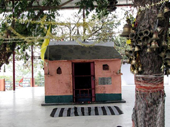
Kyunkaleshwar Temple: This temple was established by Shankaracharya during his visit to Pauri. The temple is well renowned in Pauri and nearby areas as people have a very strong belief in the temple. The main deities of the temples are Lord Shiva, Parvati, Lord Ganesha, and Lord Kartikeya. Other deities in the temple just behind the main temple are of Lord Rama, Lakshmana and Sita. One can have a spellbinding sight of the magnificent Himalayan ranges along with Alaknanda Valley and town itself from here.
Kandolia Temple: This is another Shiva temple of Pauri Garhwal District and is located in the dense forests of Oak and Pine on Kandoliya hills. Adjacent to this temple is a beautiful park and a sports complex. During summers Kandoliya Park becomes a famous picnic spot. One side of the park gives a beautiful view of Pauri town and other side of it gives a beautiful view of Gagwarsyun valley.
 Nagdev Temple: This much worshipped temple of Nag Devta is situated in a dense forest of Pine and Rhododendron. On the way to the temple an observatory is installed from where one can get a gigantic and thrilling view of the magnificent Himalayan ranges like Chaukhamba Peak, Gangotri Group of mountains, Bandarpoonch, Kedardome, Kedarnath Mountains, etc.
Jwalpa Devi: It is a famous Shakti Peeth of this area dedicated to Goddess Durga and is around 33 kms from Pauri. Special religious events are organised in the occasion of Navratra.
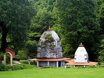
Binsar Mahadev Temple: Amidst the dense forests of Birch, Rhododendron and Deodar. Sanctum Sanctorum of the temple consists of deities, Hargauri, Ganesh and Mahishasura Mardini. The temple is believed to be constructed by Maharaja Prithu in memory of his father Bindu. This temple is also known as Bindeshwar temple. A big fair takes place here on the occasion of Baikunth Chaturdashi every year. View of clear blue sky and white spread peaks from here is magnificent. This temple is around 114 km from Pauri.
Tarakund Temple: Situated at a height of 2200 metres Tarakund is a small picturesque spot amidst lofty mountains. A small lake and an ancient temple adorn the place. The Teej festival is celebrated with great gaiety.
 Some of the popular fairs and festivals of Pauri Garhwal District that attract the devotees from all parts of the country are mentioned below.
Gindi Mela: On the occasion of `Makar Sankranti`, `Gindi` fairs are organized at some places in the southern part of the district. These fairs have their own distinctiveness and importance in the hills. As the month of `Magha` starts, a number of fairs are organized in whole area, but `Gindi` fairs are most famous in which people from the remote and far-away places participate. These fairs are symbols of bravery, joy, courage and competitive spirits.
Vaikunth Chaturdashi Mela: On the occasion of `Shukla Chaturdashi` of Kartika month, also called `Vaikunth Chaturdashi`, a fair is organized at the Kamleswar Mahadev Temple. Earlier, this fair was organized for single day in the temple site. Now, it is extended to five days including a number of other activities.
Binsor Mela: Every year on `Vaikunth Chaturdashi` and `Kartik Purnima`, two days `Binsar Mela` is organised at `Bindeswer Mahadev` temple. People from different areas of Pauri Garhwal District as well as adjoining areas Chamoli District, Almora District and Rudraprayag District participate and offer their prayers to God Shiva. Because of this, the fair witnesses a fine blend of cultural heritages of Garhwal and Kumaon regions. Folk songs and folk dances add charm to the celebrations.
These are some of the popular temples and religious events of Pauri Garhwal District that are a must visit for the travellers. Pilgrimage tourism in Pauri Garhwal District offers an enriching experience to the devotees.


