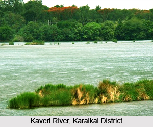
 Geography of Karaikal District is forming part of the fertile Kaveri delta and the region is completely covered by the tributaries of Kaveri River. Covered completely by a thick mantle of alluvium of variable thickness, the region is basically flat having a gentle slope towards the Bay of Bengal in the east. It is limited on the north by the Nandalar and on the south-east by the Vettar. The group of rocks known as Cuddalore formations is met with in the area adjacent to Karaikal region in Nagappattinam District.
Karaikal, situated on the east coast of India, near latitude 11 degree north in the deltaic region of the Kaveri, experiences tropical maritime type of climate with small daily range of temperature and moderate rainfall. Karaikal has an annual average rainfall of about 126 cm, 68 percent of which occurs during October to December. The amount of rainfall during the south-west monsoon period is small, being less than 20 per cent of the annual rainfall. November is the rainiest month, accounting for about a third of the annual total. The range of variation of annual rainfall is wide. Variability of annual rain fall is fairly large, so that significant variations in rain fall from year to year may be expected. Drought conditions with the annual rainfall of less than 75 percent of the normal may be expected once in three years on an average. In a year there are on an average about 55 rainy days.
The level of temperatures in Karaikal is about the same as in Puducherry. December and January are the coolest months with the maximum at about 28 degree Celsius and the minimum at about 23 degree Celsius. The level of humidity and the pattern of cloudiness and surface winds are the same as in Pond cherry. Although slight variations in the month wise occurrence of depressions and storms are noticeable, thunder-storms generally occur during April to November, particularly in April, September and October.
Geography of Karaikal District includes several river system and water resources. The main branches of Kaveri below Grand Anicut are the Kodamurutti, Arasalar, Virasolanar and the Vikramanar. Although Arasalar and its branches spread through Karaikal, the waters of Kodamurutti and Virasolanar also meet the irrigation needs of the region. Arasalar having a total run of 24 kms enters Karaikal region, a little east of Akalanganni. It forms the natural boundary line separating Niravi Commune from Tirunallar on the north-west and Karaikal on the north-east.
 The Nattar, branching off from Arasalar at Sakkottai in Thanjavur District, runs a distance of 11.2 km in a south-easterly direction across Nedungadu and Kottuchcheri. The Vanjiar fed by Arasalar, takes its course along the northern boundary of Tirunallar commune, drops on a south-easterly curve towards Karaikal commune and merges with the Arasalar, south-east of Karaikal town after covering a distance of about 9 km.
The Nular, also fed by the Arasalar, runs a distance of 13.77 km before it joins Vanjiar north-east of Karaikal town. The Puravadaiyanar and the Tirumalarajanar are the branches of Kodamurutti. The flow of Tirumalarajanar which forms the natural boundary line between Niravi and Tirumalarajanpattinam communes runs a distance of 5.13 km. before it enters the sea, north of Pattanachcheri. The Nandalar takes off from Virasolan and meanders across the northern boundary of the region.
Karaikal region gets most of its water for irrigation from Kaveri and as such ground water resources in the region have not been fully developed. Here the water table lies at depths of around 3 and 4 metres below ground level and during summer declines to 6 to 7 metres below ground level. In a number of villages of Karaikal District filter point wells piercing sandy materials down to about five metres and fitted with hand-pumps supply fairly good quality water. In many cases the quality of shallow ground water is rather poor. In the past, several attempts were made to tap ground water by means of deep tube wells for drinking and agricultural purposes.
The region is occupied by alluvium consisting of sands and clays. Data of bore-holes put down in the vicinity of Karaikal indicate that the thickness of the alluvium is possibly of the order of 68 meters. The alluvium is underlain by the Karaikal beds of Pliocene age consisting of sands, gravels and clay. Further, ground water in Karaikal is developed chiefly by means of dug wells or filter-point wells piercing blown sands and alluvium. A few bore-holes not exceeding 50 metres in depth drilled in the vicinity of Karaikal were reported to have been abandoned on account of the poor quality of water in the granular zones in the alluvium.
To the south and west of Muppattankudi and towards Mathur further west, sands are met with down to depths of 8 to 12 metres below surface. About 1.6 km south-east of Nedungadu, in the western portion of the region, confined aquifers have been tapped by a tube-well. Karaikal town gets its water by means of a battery of a shallow interconnected open wells and an infiltration gallery in the bed of Arasalar. A few villages between Akalanganni and Karaikal also get their water supply from this source.
Karaikal District is an important stratigraphic horizon which indicated the prospects of `oil shows`. The Karaikal area is completely covered by a thick mantle of alluvium. Several important mineral resources such as Brick clays and Kanker are found in the district. Karaikal District is also rich in flora and fauna.


