 Kushinagar District of Uttar Pradesh situated at around 53 kms east from Gorakhpur. This district lies between latitude 26 degree 45 minutes north and 83 degree 24 minutes east longitude. Padrauna is the district headquarters. It is 71 kms from Gorakhpur and 336 kms from Lucknow. It is a terai area covering a geographical area of 2873.5 sq kms. Kushinagar District is bounded by districts of Mahrajganj in the west, Gorakhpur District in the southern-west, Deoria District in the south and Bihar in the east.
History of Kushinagar District
Kushinagar District is named after the sacred place of attainment of Mahaparinirvana of Buddha in 483 BC. Kushinagar is identified with Kushawati (in pre-Buddha period) and Kushinara (in Buddha period). Kushinara was the capital of Mallas which was one of the sixteen mahajanapadas of 6th Century BC. According to Ramayana, Mallas was earlier part of Kosala Janpad. Kushawati capital was built by Kusha, son of Lord Rama. As per Buddha Pali literature, Kushawati was named after king Kusha. The naming of Kushawati was due to abundance of Kusha, sacrificial grass found in this region. Since then, it remained an integral part of the erstwhile Maurya Empire, Shunga Dynasty, Kushana Empire, Gupta and Harsha dynasties. Further, according to the history of Kushinagar District, Kushinara continued to be a living city till the 12th Century AD and was thereafter lost into oblivion. However, modern Kushinagar came into prominence in the 19th Century. After independence, Kushinagar remained a part of Deoria District. On 13th of May, 1994, it came into being as a new district of Uttar Pradesh.
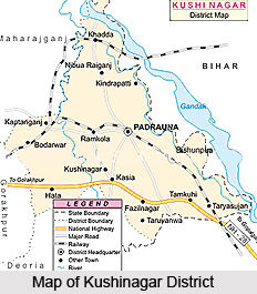
Administration of Kushinagar District
Administration of Kushinagar District is divided into four Tehsils (Revenue Sub- Divisions) presided over by a Sub-Divisional Magistrate. The four sub-divisions of Kushinagar District are Tamkuhi, Kasia, Padrauna and Hata. Tehsils are further sub-divided into 14 Development Blocks, Blocks into 140 Nyay Panchayat and these Nyay Panchayats into 944 Gram Sabhas which consists of 1620 Revenue villages. The 14 Development Blocks are Tamkuhi, Dudahi, Seorahi, Kasia, Fazilnagar, Padrauna, Nebua Naurangia, Vishunpura, Khadda, Kaptanganj, Ramkola, Motichak, Sukrauli and Hata.
Tourism in Kushinagar District
Kushinagar District is considered as a place of major tourism importance. There are several popular sites of historical and religious importance that are worth exploring. Major tourist attractions offered by Kushinagar District include Mahaparinirvana Temple
Ramabhar Stupa, Nirvana Chaitya, Matha Kuar Shrine, Meditation Park, State Museum, Wat Thai Temple, Indo-Japan-Srilanka Temple, Ruins and Brick Structures, Korean Temple, Shiva temple, Ram Janaki Temple and more.
Kushinagar District has its own cultural and historical importance.


