Introduction
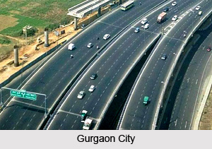
 Gurgaon District is one of the 21 administrative districts of Haryana with its headquarters at Gurgaon. This district is spread over an area of more than 2,000 sq kms. Gurgaon District is located in the southernmost region of Haryana. The rapidly developing Gurgaon city is the hub of Information Technology sector. Offices of several multinational companies are located here. Total Population of Gurgaon District as per Census-2001 is 8, 70,539.
Location of Gurgaon District
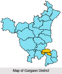
 Gurgaon District lies between 27 degree 39 minutes and 28 degree 32 minutes 25 seconds latitude, and 76 degree 39 minutes 30 seconds and 77 degree 20 minutes 45 seconds longitude. On its north, Gurgaon District is bounded by the district of Rohtak and Delhi. Faridabad District lies to its east. On its south, Gurgaon District shares boundaries with Uttar Pradesh and Rajasthan. In the west, this district is bounded by Rewari District and Rajasthan.
History of Gurgaon District
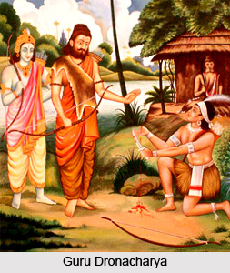 History of Gurgaon District suggests the origin of its name. It says that Gurgaon District derived its name from the name of Guru Dronacharya; the village was given to him as `gurudakshina` by his students; Pandavas. Hence, it came to be known as Guru-gram, which in course of time got distorted to its present name Gurgaon. Thus the district has been in existence since the times of Mahabharata.
Further, the history of Gurgaon District states that during the reign of Akbar, the district fell within the subas of Delhi and Agra, and comprised the sirkars of Delhi, Rewari, Suhar Pahari and Tijara. With the fall of Mughal Empire, it came under the British rule through the Treaty of Surji Arjungaon with Sindhia. The town was first occupied by the cavalry unit. The civil offices were removed from Bharawas (tehsil Rewari) in 1821 AD, when the British frontier advanced through the acquisition of Ajmer territory.
The adjoining boundaries of this district were subjected to consistent changes. Gurgaon District was divided into Parganas by British rulers and various Parganas were given to petty chiefs and granted as jagirs in lieu of military services rendered by them. These jagirs were gradually resumed and came under the direct management of the British; the last of the important changes took place in around 1836 AD. There after, the district remained unchanged until the 1857 uprising. In 1858 AD it was transferred from the North Western Provinces to Punjab. Moreover, in the composition of Gurgaon District since the beginning of the 20th century various changes have occurred.
No major change took place during 1901 to1911. Ballabgarh was one of the three tehsils comprising the then Delhi district. A part of this tehsil was transferred to Gurgaon District in 1912. This was formed into the new sixth Tehsil of the district with the same name. Minor changes occurred between Gurgaon District and Uttar Pradesh during 1931 to 1941. Under the Provinces and States Order 1950, nine villages of the district including Shahjahanpur were transferred to Rajasthan. Further, during 1951 to 1961, there was no significant change in the boundary of the district. In 1972, Rewari Tehsil was excluded from Gurgaon District and included in Mahendragarh district and in 1974, 34 villages were excluded from Palwal Tehsil. On 15th of August, 1979, Gurgaon District was further divided to form a new district Faridabad in which tehsils of Ballabgarh and Palwal were merged.
Geography of Gurgaon District
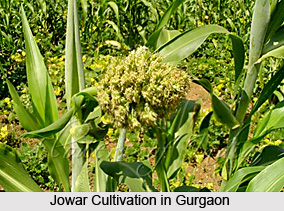 Geography of Gurgaon District includes diversified plain lands of the region. Here, the drainage problem is of a typical nature; it is difficult because of the drain tendering to flow towards inland depressions instead of flowing out into some river. The soils of Gurgaon District are heterogeneous. At most places it is rocky and water is brackish. Gurgaon District has an industrial as well as an agrarian base. The main crops cultivated here are wheat, gram, barley, bajra and jowar, oilseeds, fodder and vegetables.
The climate of the district, except during the monsoon, is characterized by the dryness in air, a hot summer and a cold winter. The year may be broadly divided into four seasons, winter, summer, monsoon and the post monsoon or the transition period. The winter starts late in November and continues up to the beginning of March. The summer is from March till the end of June. The period from July to mid September is the south west monsoon season. Mid September to end of November constitutes the post monsoon or the transition period. The normal annual rainfall in the district is 553 mm.
The rainfall in Gurgaon District increases from the west towards the east. About 77 percent of the annual rainfall in Gurgaon District is received during the south-west monsoon months. From about the beginning of March, temperatures begin to increase rapidly. May and June are the hottest months when the mean daily maximum temperature is near about 41 degree Celsius. From April onwards, hot dust-laden winds blows and weather is unpleasant. The mean daily maximum temperature in January is about 21 degree Celsius and the mean daily minimum temperature about 7 degree Celsius. Humidity is high in the south-west monsoon season. April and May are the driest months when the relative humidity in the morning is about 30 per cent and in the afternoon less than 20 per cent. Winds are generally light but gain force in the summer and monsoon seasons. In the south-west during the monsoon season heavily clouded skies generally prevail in the region. During the rest of the year skies are mostly clear or lightly clouded.
Culture of Gurgaon District
The language of Meos is Mewati, a sub dialect of north-eastern Rajasthani language.
 The language of the north and west of the district in which Ahir tribe predominates is Ahirwati, another sub-dialect of the north eastern Rajasthani, while language in east of the district in which the Jat predominate, is the Braj Bhasha dialect of Hindi language. Festivals and fairs are an integral part of the religious life and culture of Gurgaon District. The common festivals celebrated here are Holi, Janmashtami, Dussehra, Diwali, Shivaratri, etc. Mela Masani Mata or Sitla Mata ka mela and mela Chhat Bhadon or Baldev Chhat are some of the important fairs held in Gurgaon District.
Administration of Gurgaon District
Administration of Gurgaon District comprises nine development blocks namely Tauru, Nuh, Pataudi, Nagina, Punhana, F.P.Jhirka, Sohna, Gurgaon and Farrukhnagar. It has two sub-divisions - Gurgaon (North and South). The five tehsils of Gurgaon District are Gurgaon, Sohna, Pataudi, Farrukhnagar and Manesar. Deputy Commissioner is the Chief District Officer of the administration. He is assisted by Sub Divisional Magistrate heading a sub division. Additional Deputy Commissioner is in-charge of District Rural Development Agency (DRDA) for development of the district.
Tourism in Gurgaon District
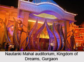
 Tourism in Gurgaon district offers a plethora of experiences to the tourists. The district houses a number of intriguing places attracting tourists from distant places. Ranging from historical places to sites of bewitching natural beauty, Gurgaon serves as the storehouse of all. The place also provides shelter to migratory birds that travel from far off countries to seek refuge from the cold winters. Parks, forts, archaeological sites, temples, mosques and lakes consolidate to make the district an ideal place to cherish a variety of experiences.
Dhankot : It is located at about 11 kilometres from Gurgaon on Farrukhnagar Road. Legends say that in olden days, milk was supplied to Guru Dronacharya from this place and also to his pupils at Gurgaon. In a Buddhist literature the place has been identified as the place that was once visited by Lord Buddha.
Saiyad : It is also situated near Gurgaon and is believed to be the place where Guru Dronacharya lived with his pupils. The place has also furnished several painted grey wares and remains of late medieval era.
Ata : Ata served as a significant centre of art and architecture during the period of Gurjara-Pratiharas. Two exquisite idols have been found in the place which includes Uma Maheshvara seated on Nandi, belonging to early medieval era, and Adinath of medieval period.
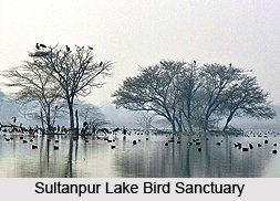
Sultanpur Lake Bird Sanctuary : Sultanpur lake bird sanctuary is a paradise for bird watchers. The place was found by Peter Jackson who is considered as the renowned authority on bird watching. It was opened to public on 6th of February 1972. Migratory birds from Siberia and Europe flock at the sanctuary with the onset of winters and return back to their homes during summers. Watch tower and observation hides have been made to facilitate bird watching. Camping facilities are also provided in the sanctuary.
Sohna Sulphur Springs and Tourist Complex : Sohna is a small town housing a sulphur spring. The water of the spring is strongly sulphurate in nature with a temperature that varies form 46 to 51.7 degree centigrade. The main site is known as Shiv Kund which is believed to be the ancient residence of hermits. The water of the spring also possesses curative effect for diseases like rheumatism, gout and skin infections. The site is considered as a holy place for the Hindus who visit this place for a sacred dip during solar or lunar eclipse and Somavati Amavasya. Vibrant flowers and lush green shrubs adorn the place. The picturesque landscape has strolling peacocks and the place exhibits enchanting beauty at nights.
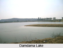
Damdama Lake : It is one of the largest natural lakes of Haryana. The mountain ranges surrounding the lake provide a splendid view. It is a popular tourist as well as picnic spot. Activities like boating, trekking, para sailing, hot air ballooning, angling, cycling and rowing can be cherished here. The place is also ideal for nature walks.
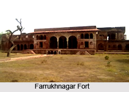
Farrukhnagar Fort : It is situated in Farrukhnagar town of the district. One of the most important features of the fort is formed by Dilli Darwaza which is one of the three surviving entrances of the town. A large part of the fort is presently in ruins.
Jama Masjid : Jama Masjid is also located in Farrukhnagar town. It has an impressive red sandstone structure built by Faujdar Khan. Arabic inscriptions belonging to the period of Ghiyas-ud-din-Balban, Sultan of Delhi, are found on two slabs on the southern wall of the fort.
Sanghel : Sanghel is enlisted among the highest mountains of the district. It offers a picturesque view of the beautiful surroundings. It also houses a number of stone sculptures having images of Narasimha and Varaha belonging to medieval era and Lakshmi belonging to late medieval era. Numerous historic artefacts have also been found in this place.
Other Tourist Places in Gurgaon District : In addition to these, other tourist places of Gurgaon district include Aliwardi Masjid, Badshahpur, Baoli Ghaus Ali Shah, Ferozpur Jhirka, Havelis, Leisure Valley Park, Malab, Nuh, Pataudi Palace, Sethani Ki Chhatri, Sheesh Mahal, Shri Sheetala Mata Mandir, Shrine of Budho Mata, Sita-Ram Mandir, Ujina and Urusvati Museum of Folklore.


