 Geography of West Champaran District is divided into few distinct tracts. The first consists of the hilly tract of Sumeswar and Dun range in the north at the foothills of Himalayas. It is noticeable that the soil even at the foot of the hills has no rocky formation and wherever water can be impounded, a rich growth of crop is possible. The hilly streams, however, play havoc by bringing down huge quantities of sand and destroying cultivable lands. The hills contain large stretches of forests. Next to the hilly area comes the Terai region, which is largely populated by Tharu Tribe of the district. The Terai region is followed by fertile plains occupying the rest of the district. This plain itself is divided into two well defined tracts by the little Gandak and have markedly distinct characteristics. The northern portion is composed of old alluvium and has a considerable area of low land.
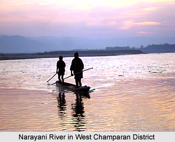
A number of streams flowing southwards traverse geography of West Champaran District. The southern portion of the tract is characterized by stretches of upland varied in places by large marshy depressions known as `chaurs`. The Gandak or Narayani and Sikrahana are the two important rivers of this district.
Geography of West Champaran District includes a cool climate as compared to the adjoining districts of the state. The terai area comprising mainly Ramnagar, Bagaha and Narkatiaganj is considered unhealthy while all other areas have a healthy climate. Winter begins in November and lasts till February, followed by hot summer months when temperature rises to maximum 43 degree Celsius. Rains set in during the later part of June. The district receives some winter rain also. Rainfall is heavier than most of the districts and is especially heavy in the terai region.
However, West Champaran District has recently suffered large scale denudation of forests. Forests are confined to the northern tract and particularly the Sumeswar and the Dun ranges are covered with forests. Tirhut, Tribeni and Done canals are the most prominent canals operating in this district. The Dun and Sumeswar hills in the extreme north, which are the continuation of Shivalik hill range, are formed of ill compacted sandstone. There are beds of Kankar (sandstone) in parts of the district and saltpetre is found almost everywhere.


