 Ratnagiri is a typically Konkan tract. It has a monsoonal land with great contrast in the nature of heights and plains, of wet and dry seasons, of forested and cultivated stretches, of bare lateritic plateau surfaces and intensely tilled valleys. Geographically the region is divided into three regions. The eastern portion consists of the main areas of the Sahyadrian Range and its transverse members sprawling into the Konkan plain. To the west of this Sahyadrian and sub-Sahyadrian region of the district, the hilly landscape opens out to form an undulating aspect which is best called plateau surface deeply notched by the parallel flowing streams and their tributaries. It is difficult to say where this plateau tract of the Ratnagiri district ends and where the coastal ` plains` begin, for these landscapes dovetail into each other so frequently that any clear-cut demarcation must appear artificial. Yet, there is a visible change as one approaches the coastline; wide estuaries, open expanses of cultivation and the salt laden atmosphere have an unmistakable environment of their own. The lateritic areas form water sheds between rivers and their promontories-which are the sites of the famous Maratha forts-projecting into the Arabian Sea.
The outstanding feature in the relief of the district is its highly uneven nature and the very narrow riverine plains that fringe the coast-line. Over 85 percent of the land surface is hilly. On the east this consists of the steep and forbidding scarp of the main Sahyadris. In the centre are the transverse chains of small hills, which project from the main range, and develop higher elevations in their middle portions. These are separated from each other by undulating plateaus which gain in area and scenic effect westwards as the coast-line is approached. The coast-line is irregular marked by alternating bluff and curving bays, but it is shallow and hence has a limited use for navigation. The landscape of the Ratnagiri district is basically influenced by the Deccan lavas which cover most of the area except the southern and south-eastern part which is underlain by metamorphic types. The typical lava landscape developed under tropical humid conditions persists almost everywhere. But locally even this general aspect has five different types, the coast line, the estuarine alluvial plains and basins of the main rivers, the laterite plateaus, the highly eroded remnant hills partly detached from and partly connected to the main range, and the scarp face of the Sahyadris proper. These patterns as they occur from west to east.
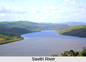
The drainage of the district is mostly parallel, but the tributary pattern in the centre tends at places to be rectangular, suggesting the adaptation of streams to local rock structure. This adaptation to structure is also well seen in the sharp meanders which many rivers show in their middle and lower reaches. The major rivers receive their waters from the Sahyadrian main range, and flow westwards to the Arabian Sea through deep well cut channels. In length, they seldom exceed forty miles. Each of them, however, has a small drainage area and hence they are of small size and volume. The major rivers flowing through the district of Ratnagiri are Savitri, Vasishthi, Jagbudi, Shastri, Ratnagiri, Muchkundi, Jaitapur, Vaghotan, Deogad, Achra, Kalavli, Karli and Terekhol.
The climate of the district, though moist, is generally healthy. The rainfall is plentiful and regular. The year may be divided into four seasons, the summer season from March to May, the south-west monsoon season from June to September, the post-monsoon season from October to November and the winter season from December to February. The monsoon bursts over the district generally by the beginning of June and the rains continue with little intermission till about the middle of October. The average annual rainfall for the district as a whole is 3,188 mm. In the hot season temperature rises slowly from March, and May is the hottest month. With the onset of the monsoon, temperature drops by three to four degrees. Owing to the proximity of the sea, the district is on the whole very humid. Even during the winter and summer the relative humidity seldom goes below 50 per cent. During the pre and post monsoon months, the district experiences very strong winds sometimes reaching gale force particularly near the coast. This is accompanied by heavy rains in association with cyclonic storms which develop in the Arabian Sea and move in close proximity to the coast. Thunderstorms are common in the post monsoon months and the latter part of the hot season.


