 Geography of Chennai district is today devoid of most of its forest area. The district possesses a low-lying area which is almost flat like a pancake. The even topography of the land throughout the district makes sub-divisions into natural regions much difficult. It rises slightly with the increase in distance from the sea-shore but the average elevation of the city is not much above the mean seal-level, while a majority of the localities are just at sea-level and drainage in those areas remain a major problem. It is located on the north-east end of Tamil Nadu on the coast of Bay of Bengal and having its border as the Bay of Bengal to the east the remaining three sides by Chengalpattu and Thiruvallur Districts. From very early times, Chennai was reputed for its pleasant scenery and was said to be a town open to sky and full of garden of mangoes, coconuts, guavas, oranges, etc.
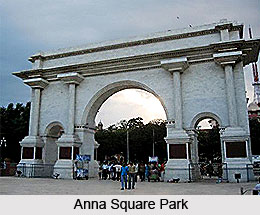
Earlier, when the district was not so congested, gardens and groves formed the common feature and most of the roads were bordered by frequent groves of palm and other trees. Even several houses too had gardens displaying fine trees canopied by green bough and creepers. However, today, the district of Chennai is devoid of any forest areas but can still be proud of some of the well maintained green belts found in the Peoples park, the Napier park, Children`s Park Guindy, the Horticulture-gardens, Independence Park, My Lady`s Park, Snake Park, Nageswara Rao Park, Nehru Park, Anna Square Park, the Theosophical Society Campus, the Raj Bhavan and a number of bungalows and newly developed colonies where provisions of public parks, etc. have been provided.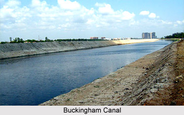
The indigenous trees found in this district include mango, tamarind, neem, banyan, rain-tree, vagai, palm, coconut and pipal. Stretches of casuarina plantations are still seen on the sea-coast beyond the mouth of the Adyar in the South and Tondiarpet in the North, supplying firewood to the city. However, house gardening has decreased these days because of the shortage of water and lack of space.
The district of Chennai is intersected by two languid streams, the Adyar and the Cooum. Cooum runs through the district and empties into the sea near Adyar River. These two rivers are almost stagnant and carry very little water except during rainy seasons. Though the river Adyar can be traced to a point near Guduvancheri village, it looks like a stream only after it receives the surplus water from the Chembarambakkam tank as well as the drainage of the areas in the south-west of Chennai. The river has no commercial importance, but the fishermen in the neighbourhood make their living by fishing in the river. There is a navigational canal called the Buckingham canal which runs through the states of Tamil Nadu and Andhra Pradesh. It parallel to the Coromandel Coast within the limits of five kilometres from the coast and joins up a series of natural backwaters and connects all the coastal districts from Guntur to South Arcot. The other canal in Chennai is the Otteri Nullah which commences from the village Mullam, runs eastwards upto Purasawalkam and then passes through Buckingham and Carnatic Mills and finally joins the Buckingham Canal, north of Basin Bridge Railway Station. The district of Chennai possesses 25.60 kilometres of sea coast which is flat and sandy for about one kilometre from the shore.


