 Koderma District was created on 10th April, 1994 out of the old Hazaribagh District of North Chota Nagpur Plateau Division. It is known, as the Mica capital of India. Koderma and Tilaiya are only two important towns in the district. Koderma is well known for rich mica deposits and is also called as `Abharkh Nagari`. More than 50 per cent of the total mica production of the country produced from here. Altitude of Koderma District from the sea level is 397 meters. It is essentially an under-developed, thinly populated district having varied but limited endowment of natural resources. The five blocks in the district are namely Koderma, Jainagar, Markacho, Satgawan and Chandwara. Administration of Koderma District is headed by Deputy Commissioner. Koderma and Jhumri Tilaiya are the only two towns in the district. Koderma District has one sub-division namely Koderma. The five developmental blocks in the district are Koderma, Jainagar, Markacho, Satgawan and Chandwara. The administrative set-up of Koderma District has five revenue circles. Number of Panchayats in the district are 80 and number of villages in the district are 717.
History of Koderma District
Koderma District is bounded by 24 degree 15 minutes 46 seconds and 24 degree 49 minutes 18 seconds north latitude and 85 degree 26 minutes 1 second and 85 degree 54 minutes 16 seconds east longitude. This district covers an area of 1500 sq kms. It is bounded on the north by the Nawada District of Bihar, on the south by Hazaribagh District of Jharkhand on the east by Giridih District of Jharkhand and on the west by Gaya District of Bihar.
Geography of Koderma District
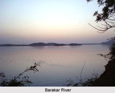
Koderma District lies in the Chota Nagpur Plateau at 397 meters above the sea level. The area exhibits undulating topography comprising hills, hillocks, plains and mountains. Northern part of Koderma District is occupied by Koderma Reserve Forest. The highest peak is Debour Ghati (677 metres) which is the state boundary of Jharkhand and Bihar. Topography of Koderma District also includes several streams. River Barakar flows from west to east in the southern part of the district and supports Tilaiya Dam, a multi purpose dam construction on it. Poanchkhara, Keso, Akto, Gurio, Gukhana Nadi are the main tributaries of Barakar River.
Sakri River is the main river in the northern part of the district which flows from south and east to North West. Ghggnna Nadi and Chhotanari Nadi are the tributaries of Sakri River. Mahua, Banyan Tree, Sakhua, Palas, Pipal, Neem Tree, Khajoor, Bamboo are found in the region. The climate of Koderma District can be described as a transition between the dry and moderately extreme climate of the northern India and the warm, humid climate of Bengal Basin. The climate of Koderma District can be described as a transition between the dry and moderately extreme climate of the northern India and the warm, humid climate of Bengal Basin. The climatic year of Koderma district can be divided into four principal seasons. Average rainfall of the district is 1090 mm yearly. Laterite soils are mainly found in this district. This soil is characterized by its acidic nature and not suitable for traditional agriculture.
Demography of Koderma District
According to the Population Census in the year 2011, Kodarma District had population of 717,169 of which male and female were 367,952 and 349,217 respectively. The population of Kodarma District constituted 2.18 percent of total population of Jharkhand. The average literacy rate of Kodarma in 2011 was 68.35 percent compared to 52.20 of 2001. If things are looked out at gender wise, male and female literacy were 81.25 and 54.77 respectively. The total literates in Kodarma District were 402,361 of which male and female were 245,257 and 157,093 respectively. The population density of Kodarma district is 427 people per sq. km.
Koderma town is on National Highway 31 connecting Ranchi and Patna. Koderma Railway station is also on the grand chord railway line connecting Kolkata and Delhi.


