Introduction
 Jalna district was formerly a part of the Nizam state. It became a part of India, as a tahsil of Aurangabad district, after the Marathwada Mukti Sangram. The district of Jalna, as distinct from Aurangabad, was formed on 1st May 1982 by carving out Jalna, Bhokardan, Jafrabad and Ambad tahsils from the Aurangabad district and Partur tahsil from the Parbhani district. The district headquarters is at Jalna and it is well connected to the state capital and national capital by broad gauge railway line. The major towns of the state are also connected by state highways. Jalna district is well-known for its hybrid seed processing industries, steel re-rolling mills, bidi industry and agro-based industries like dal mill. The district is also known for Jamb-Samarth, which is the birthplace of Sant Ramdas Swami, who was the Guru of Chatrapati Shivaji Maharaj. The district of Jalna covers an area of 7,612 Sq.Kms, which is 2.47 percent of the total area of the state.
Location of Jalna District
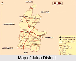
The district of Jalna is situated approximately in the centre of the state of Maharashtra and in the northern direction of the Marathwada region. It lies between the north latitudes of 19 degrees 1 minute and 21 degrees 3 minutes and the east longitudes of 75 degrees and 76.4 degrees. The district is bounded by Jalgaon district in the north, Parbhani and Buldhana in the east, Beed district in the south and Aurangabad district in the west. It covers an area of 7,612 Sq.Kms, which is 2.47 percent of the total state area.
Geography of Jalna District
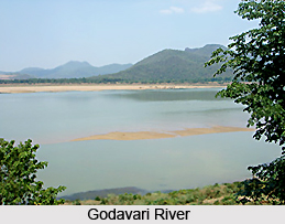
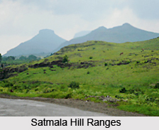 Geography of Jalna district is such that the district has a moderately to gently sloping undulated topography. The northern part of the district is occupied by the Ajanta and Satmala hill ranges. A major portion of the district, almost 95 percent, falls in the Godavari river Basin. The Godavari River flows along the Southern boundary in a west to east direction. The major tributaries of the Godavari River which flow through the district are the Dudhana River, Gulati River and the Purna River. A huge part of the district falls in the Purna sub-basin. The Purna River flows through the flows through the central part of the district and meets the river Godavari in the neighbouring district. The Rivers Khelna and Girja are other important tributaries of the river Purna which flow through the district. A very small part of the district in the north-eastern part lies in the Tapi River basin. The general slope of the district is towards the southeast, and the average altitude above mean sea-level is 534 metres.
The district has a sub-tropical climate, in which the bulk of rainfall is received from the southwest monsoon, between June and September. The average annual rainfall of the district ranges between 650 to 750 mm. The district often experiences drought with rainfall recording as low as 400 to 450 mm. The rainy season is followed by winter, which lasts up to February. During this time, the minimum temperature ranges between 9 to 10 degree Celsius and maximum temperature ranges between 30 and 31 degree Celsius. The winter is followed by hot summer, which continues up to June. The maximum day temperature ranges between 42 and 43 Celsius during summer.
The entire district is occupied by basaltic lava flows of the Deccan traps of upper cretaceous to Eocene age. The lava flows are piled over one another. The individual flow thickness ranges between 20 to 30 metres. 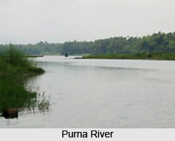 The individual flow has two distinct units. The upper part is vesicular in nature and vesicles are filled with secondary minerals like zeolite and quartz (e.g. Moss Agate, Zebra Agate and Green Agate) which is often called zeolitic trap. The lower part of the lava flow forms the massive basalt, and is often called massive trap. Alluvial deposits along the major rivers overlie the Deccan traps. The alluvium consists of clay, silt and sand. The thickness ranges between 10 to 20 metres. The alluvium forms a very fertile land. Since the major part of the district forms the moderately dissected basaltic plateau, it has moderate to good groundwater potential. The northern part of the district forms the highly dissected basaltic plateau, and consequently the groundwater potential here is quite poor.
Of the total geographical area of the Jalna district, around 85 percent is under agricultural use. Out of the total 7, 61,200 hectares of the geographical area, 6, 51,553 hectares of land has been put to agricultural use. The major portion of this area, around 75 percent, is under Kharif crops, whereas the rest is under Rabi crop cultivation. Among the major crops grown in the district are jowar, wheat and cotton. Around 15 percent of the area is double-cropped whereas only 7.8 percent of the area is irrigated which is far below the state average.
Demography of Jalna District
 According to the last Census in 2001, Jalna district has a total population of 16,12,357 and the density of population is 209 persons per square Km. The population of males in the district is around 8,25,977 while females in the district make up 7,86,380 of the population. The male-female ratio in the district is 1000 / 952, i.e., 952 females per 100 males. Literacy rate in the district is 64.52 percent. The male literacy rate is 79.17 percent whereas the female literacy rate is 49.25 percent.
Administration of Jalna District
Jalna district came into existence on 1st May 1981 with five tahsils namely Jalna, Ambad, Bhokardan, Jafrabad, Partur and one Jalna subdivision. Jalna city was declared as the district headquarters. On 26th January 1992 one more Subdivision came in to existence at Partur, and on 15th August 1992 three new tahsils were reconstituted namely Mantha, Badnapur and Ghansavangi. So at present there are 2 Sub-divisions, 8 Tahsils and 970 Villages in Jalna district. The administration of Jalna district is headed by the District Collector. Collectorate is the backbone of district administration. All kinds of decisions, law and order, revenue, elections, dealing with natural calamities etc are some of the responsibilities of the Collectorate.
Economy of Jalna District
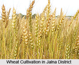 Economy of Jalna district is primarily based on agriculture and agro-industries. Out of the total geographical area of 761200 hectares, 6, 51,553 hectare of land is under agricultural use. This accounts for nearly 85 percent of the total geographical area of the district. Under agricultural production, the bulk of production is of kharif crops whereas the rest is under rabi crop production. The major crops grown here are jowar, wheat and cotton. The area under double crops is just 15 percent while area under irrigation is only 7.8 percent which is far below the state average. The current irrigation potential in the district is 66,097 hectares, while the area under well irrigation is about 35,000 hectares. The development plan has envisaged irrigation potentials of up to 1, 18,000 hectares.
Jalna district has a moderate industrial background, as the state of industrial development is not too high here. Among the existent industries here, the district is especially famous for the seed and steel industries. The industrial development in Jalna is mostly based on Engineering, Plastic and Agriculture. Pulse mills, oil mills, refineries, steel re-rolling, plastic, tiles and cement pipe, fertilizers, insecticides, pesticides and the co-operative sugar factories are also playing an important part in the industrial development of Jalna. There are also cotton ginning and pressing factories and an agricultural market produce committee handling large quantities of all kinds of agricultural produce, including cotton.
In view of the overall industrial backwardness of the region, the state government has initiated a master plan to encourage the establishment of small and large - scale industrial units. Under this plan the Maharashtra Industrial Development Corporation (MIDC) has set up an industrial area in Jalna consisting of large-scale, medium scale and small scale industries. Jalna industrial area has a large number of steel rolling mills, a unit manufacturing ball bearings, agro based units like dal mills, the most significant being large number of seed manufacturing units. Mahyco, Mahindra, Bejo-Shital are some of them. NRB bearing Ltd is the leading manufacturer of ball bearings used in automobiles and other heavy industrial purposes. There are four sugar factories in the district. These are Jalna Sahkari Sugar Factory at Ramnagar, Samarth Sahkari Sugar Factory at Samarthnagar, Bageshwari Sahkari Sugar Factory at Partur and the Rameshwari Sahkari Sugar Factory at Bhokardan. The MIDC has recently announced its plans to setup a bio technology park (BT Park) at Jalna with the help of private sector units. This park will give a tremendous boost to the BT sector in the backward area of Marathvada. At present 6 industrial areas are under MIDC Jalna.
District Industries Center (DIC)
DIC Jalna helps the unemployed for starting up business and Small Scale Industry (SSI).
The DIC and M.I.D.C. support the unemployed in the following ways:
• Providing training and guidance to the unemployed
• Pursuing Banks and financial institutes, for loans of applicants.
• Getting available land in the Industrial Area.
• Amenities like Electricity, Water, Roadways and Telephone.
• Recommendations for supply of Raw Material.
• Availability of Market.
Some of the schemes available through the DIC are Prime Ministers Rojgar Yojna (PMRY), Seed Money Scheme and DIC Loan Scheme (For rural workers).
Pilgrimage Tourism in Jalna District
 Pilgrimage tourism in Jalna district involves visiting the various temples situated here. A number of these temples are ancient constructs, such as the 300 year old Shree Jagdamba Devi at Matha, or the 250-year old Anandi Swami Temple. The temples are visited by a number of devotees from near and far, and they are dedicated to a number of different Gods and Goddesses. Most of these places of pilgrimage tourism also hold fairs annually or more than once in a year and these fairs are visited by a number of devotees. Apart from the many temples, there is also a place of Muslim worship, namely the Kali masjid, found located in Jalna district. The various places of pilgrimage tourism in Jalna district are discussed below.
Shree Ganesh of Rajur : There is a temple of Lord Ganesha located at Rajur, 25 kms north of Jalna city. On every Chaturthi, a number of pilgrims gather to worship the deity. There is a fair held at the temple on the occasion of Angarika Chaturthi. Rajur is considered to be one of the complete piths of Lord Ganesha in the Ganesh Puran. Other Piths are at Morgaon, and Chinchwad (Pune). The remaining half pith is at Padmalaya.
The Matsyodari devi Temple : The Matsyodari devi Temple of Ambad is situated 21 Kms south of Jalna city. The temple is so-named because the temple is situated on a hill which resembles the shape of a fish (matsya). It is believed to be one of the oldest temples in the region. A largely attended annual fair is held at the temple in October, in Navratra.
Jamb Samartha : 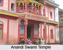 Jamb Samarth is the place where the Sant Ramdas Swami born. This place is in Ghansavangi tahsil of Jalna district. Samartha Ramdas was born on Chaitra Shukla Navami Shake 1530 (as per Hindu Calender) at 12 P.M., exactly at the time of Ram Janma (Lord Rama`s birth ). He was the younger son of Suryajipant Thosar Kulkarni and Ranubai. His actual name was `Narayan`. There is a temple of Lord Rama situated in the Sant`s home. The temple was built in the memory of Sant Ramdas swami. A large annual fair is held at the temple on the occasion of Ramnavami.
Jalicha Dev (Shri Chakradhar swami) : Jalicha Dev is one of the most important holy sites for the people following Mahanubhav Panth. It is belived that Shri Chakradhar Swami resided here for some time. It is in the Bhokardan Tahsil on the north side.
Anandi Swami Temple : This temple is 250 years old and was built by the Maratha warrior Mahadji Shinde, on the place where Shri Sant Anand Swami had gone under `Samadhi` in old Jalna. On each Ashadhi Ekadashi, a fair is held here which is attended by a lot of people.
Mamam Devi Temple : This temple is of Mamam Devi is at Mastgad, Old Jalna. Kirtan, Bhajan and other holy rituals are performed daily in this temple. A number of people come here for Darshan, especially in Navratra.
Guru Ganesh Bhavan : 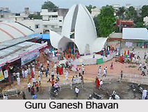 Guru Ganesh Bhavan is an important holy site for the followers of Jainism. Guru Ganesh is also known as Karnatak Kesari. The temple is being maintained by a trust. The trust also runs institutions such as schools, library, school for the blind and even a Gaushala. The Guashala is the largest one in the whole Marathwada region.
Shree Jagdamba Devi : The Shri Jagdamba temple of Matha is situated in 2 kms to the north of Matha city on a hill spot. It is a 300 year old. Many people visit the temple for a darshan, especially on Tuesday. Annual fairs are held ad Navratra and Chaitra Purnima which is attended by a large number of people.
Kali Masjid : There is old mosque situated at Court Road, old Jalna named as Kali Masjid. The mosque is around 400 years old and has been built in blackstone by a holy saint named Jamshed Khan. Members of the Muslim community regularly offer prayers here and Eid Namaz is also arranged for at the mosque.
These are the various places of pilgrimage tourism located in Jalna district.


