Introduction
 The Unnao town is the headquarter of the Unnao district. About 1200 years ago, the site of this town was covered with extensive forests. Godo Singh a Chauhan Rajput founded the town and named it as Sawai Godo. Then Unwant Singh, a Bisen Rajput built a fort here and renamed it as Unnao.
History of Unnao District
In ancient times, the areas of Unnao formed as a part of the Koshala Mahajanpada. Later it was included in Oudh. After the first War of Indian Independence in the year1857, British East India Company`s power has been transferred to the British Queen. According to queen`s order the civil-administration was re-established in the district, which was named Unnao with the head quarters at Unnao. In the same year the Unnao town was constituted a Municipality.
Geography of Unnao District
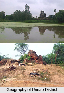 Unnao District is roughly a parallelogram in shape and lies between Latitude 26 degree 8 minutes and 27 degree 2 minutes North and Longitude 80 degree 3 minutes and 81 degree 3 minutes East. It is bounded on the North by Hardoi District, on the East by Lucknow District, on the South by Rae Bareli District and on the West by the Ganga which separates it from districts of Kanpur and Fatehpur. The district covers an area of 4589 Sq. Km. Ganga and Sai the chief rivers of the district have played an important role in fashioning the topology of the district which may be divided into two main parts - the Lowlands and the Upland.
Lowlands of Unnao District : These tracts comprising about 23.7 percent of the total area of the district lie along the Ganga in the west and along the Sai in the extreme north and east. The lowland of the Ganga also known as the tarai or khadar lies between the main channel of the river, and its old high bank. It varies in width from a km to about 10 km getting wide wherever the Ganga meets its tributaries, for instance, in the north-west and in Pariyar Pargana. The narrowest section of the tract lies in the pargana Unnao near the railway bridge over the Ganga. The Lowland is liable to frequent floods and is thinly populated. A considerable area of the tract is overgrown with grass and babul trees. The characteristic soil is stiff clay except where sand has been deposited by fluvial action. The lowland produces usually a precarious Kharif harvest and good Rabi crops in a succession of dry years but it is disappointing in a wet cycle. Along the immediate bank of the river, there is a narrow strip of alluvial land, constantly subject to inundations. The Ganga lowlands comprise 19 percent of the total area of the Unnao district. The lowland of Sai is similar though smaller in extent. It contains mostly a stiff and moist soil liable to get waterlogged in wet years and produces reh which considerably reduces its fertility.
Upland of Unnao District : Extending from the old high bank of Ganga to the Sai valley, the upland comprises about 76 percent of the area of the district. The course of the high bank, though irregular, is well defined. On top of the high bank, there is a belt of high soil, with a width of 1.5 km to 7 km. In the upland, the surface is gently undulating, the water table low, and the irrigation facilities scanty. Another belt of similar light soil is met with along the banks of the Sai. The soil occasionally rises to bhur and, in parganas Sikandarpur and Faterpur Chaurasi, there are substantial sandy bluffs projecting into the Tarai. Further inland, the tract is mainly of fertile stiff loam broken by large usar wastes and shallow rice depressions. At places, ridges of sandy soil cause large depressions of clay. The deeper of these depressions form permanent lakes and tanks. The depths and sizes of these lakes and tanks increase as one proceeds from north to south. The streams running through the tract are comparatively unimportant, with the exception of the Basha and Loni streams. The country on either side of the former, which springs in the bhur tract in the North West of pargana Jhalotar-Ajgain and runs, like a stream, through parganas Gorinda-Parsandan, Purwa and Mauranwan and then leaves the district for Rae Bareli, is characterised by frequent outcrops of bhur. It provides a cheap and easy means of irrigation and excellent crops of rice are, in many places, grown in its bed. The Loni is shallow at its source, but during the rains, it flows in a wide bed in which excellent crops of transplanted paddy are grown.
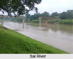 River Systems of Unnao District : The Ganga and the Sai are the main rivers of the district, the former making its western and southern boundaries and the latter, for the greater part of its course, forming its northern and eastern boundaries. Among the other mainstreams of the district are Kalyani, the Tanai, the Loni and the Morahi (Naurahi), all tributaries of the Ganga. These rivers generally run dry during the hot weather, but hold water during the greater part of the year and are utilized for irrigation.
The only great river of the district is the Ganga River which first touches the district near the village of Purwa Gahir, in Pargana Bangarmau and flows south-eastward, seperating this district from districts Kanpur and Fatehpur. Generally it flows from north-west to the south-east, but it makes several sharp bends such as those near Umriya Bhagwantpur, and Rustampur in tehsil Safipur, Rautapur in tehsil Unnao and Ratua Khera and Duli Khera in tehsil Purwa. The Ganga receives the Morahi near Baksar where it flows close to its old high bank. It leaves the district at a short distance from Baksar.
The river is not, however, put to use either as a waterway or as a source of irrigation. There are several ferries for pedestrians and pilgrims but none of them approaches what may be termed a trade route. The river cannot, as a rule is utilised for irrigation owing to the height of the bank but certain of its small drainage channels or sotas, which run island for a considerable distance in some parganas, are sometimes used to irrigate crops grown in low-lying alluvial lands. Otherwise, cultivated lands lie at great distances and cannot be irrigated from the river whose water would, in order to irrigate these lands, have to be passed through the sands on the sides of the river, and in the process be greatly washed, if not altogether absorbed. The main channel of the river is subject to constant variation and the cultivation in its immediate neighbourhood is, therefore of a shifting kind.
It appears from its old high bank that the river has a general tendency to shift its course to the west. In the days of Akbar, the river skirted the village of Ghatampur but has since then so altered its course that it now runs about 8 km to the south-west of this village.
There is unusually large number of swamps and lakes of great size and value, particularly in the southern and eastern parts of the district. The larger lakes, which hold water all the year round, are the Kundra Samundar near Jhalotar, the lake near Nawalganj, the wide expanse of water near Kantha and the long chain of lakes in pargana Mauranwan. In Tehsil Safipur, the more important tanks are those at Mawai-Bhari and Kursat and the Harial Tal near Mustafabad. In Tehsil Hasanganj, besides the Kundra Samundar at Mawai, there are the Kulli Bani and Jalesar tanks near Ajgain and the chain of lakes called Basaha, which it seems, partakes of certain characteristics of a stream also, travelling a distance of 96 Kms in the district and eventually leaving it for district Rae Bareli where it is reckoned as a tributary of the river Sai. In the western part of the Tehsil are the Katgari Lake near Asiwan and the stretches of water at Amarpur, Sambha, Sheothana, Marenda and Asakhera, but in its northern and eastern parts, there are only small and very shallow tanks which dry up when rainfall is deficient. In Tehsil Unnao there are no important lakes, but a number of very shallow depressions, which get filled up with water during the rains and yield excellent crop of rice.
In Tehsil Purwa there are many lakes, situated in a well defined belt stretching along the whole length of the tehsil. The main among them are the lakes at Kantha, Bhadain, Unchagaon, Qila, Akhori, Miri, Zorawarganj and Sarwan, the Barhna tank near Sagauli, the Mohan and Sukrar lakes near Mauranwan, and several others like the Bharda Lake, skirting district Rae Bareli. Besides these, there are the tanks at Sahrawan, the Bhundi tank at Gulariha, and the Kumbha tank at Bhagwantnagar. The lakes at Kantha, Sagauli, and Barela contain water all the year round, while the others generally provide irrigation for the Rabi crops only, drying up in the years of drought. These lakes and tanks abound in fish, and singhara (water chestnut) is very extensively grown in them.
Geologically the district forms part of the vast Indo-Gangetic alluvial tract, of which the origin is attributed to a sag in the earth`s crust, formed, in the upper Eocene times, between the northwardly drifting Gondwanaland and the rising Himalayan belt, and gradually filled in by sediments so as to constitute a level plane with a very gentle seaward slope. The alluvium formation of the district, comprising sand, silt & clay with occasional gravel, is of the early quaternary to sub-recent age. The older alluvium called bhangar, forms slightly elevated terraces usually above the flood levels. It is rather dark in colour generally rich in concretions and nodules of impure calcium carbonate, locally known as kankar. The newer alluvium, called khandar, forming the lowlands between the Ganga and Bhangar, is light colored; poor in calcarious contain and composed of lenticular beds of sand, gravel and clays. The economic minerals found in the district are kankar, reh and sand.
Economy of Unnao District
Unnao is famous for its leather industries and leather goods. The biggest industries here are of tanneries. Topographical status of industrial area is congenial for industrial requirement. Such as totally free from residential vicinity, availability of roadways, railways and airways near to the city. Banks and the financial institutions like IDBI, PICKUP etc. are also available near the city. Unnao Industrial areas currently having 50 industries, comprising mainly of leather industries and most of them are export oriented units. The prominent industries are Mirza Tanners limited, Super house Leather Limited, Kings international limited, Rehman Exports, Zam Zam Tanners
Government and Politics of Unnao District
A District Magistrate belongs to an officer of Indian Administrative Service, is the head of the Unnao District. Different Government official staffs assist him.
The Superintendent of police, an officer belonging to the Indian Police Service, is responsible for maintaining law and order in the district.
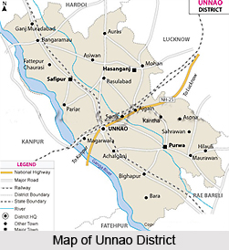
Divisions of Unnao District
Unnao district is divided in to five Tehsils namely Unnao, Hasanganj, Safipur, Purwa and Bighapur. There are 16development blocks namely- Ganj Moradabad, Bangarmau, Fatehpur Chaurasi, Safipur, Miyanganj, Auras, Hasanganj, Nawabganj, Purwa, Asoha, Hilauli, Bighapur, Sumerpur, Bichia, Sikandarpur, Sirausi, Sikandarpur karan.
Demographics of
As per 2001 Census, Unnao had a population of 144,917. Males constitute 53% and female constitute 47% of the total population. 13% of the population is under six year of age. Unnao has an average literacy rate of 68%, higher than the national average of 59.5%. Male literacy is 72% and female literacy is 63%.
Culture of Unnao District
 The most popular Hindu festivals of Unnao are,
Karva Chauth- This festival falls after nine days of Dussehra. Married Hindu women for the safety and prosperity of their husbands hold Karva Chauth.
Annakoot- Annakoot is celebrated which is devoted to feasting and Govardhan Puja in the evening and rounded up next day by Bhaya Dooj.
Shitla Ashtami- this festival falls after eight days of Holi. It is devoted to the goddess of small pox.
Ram Navami- This festival is celebrated as Lord Ram`s birthday.
Nag Panchami-In this day everyone worship the snakes.
Janmashtami- It is also an important festival of Hindu, celebrating the birthday of Lord Krishna.
Bharat Milap- It is celebrated in the month of October. It pertains to the episode of the return of Lord Ram to Ayodhya after 14 years of exile and his reunion with his brother Bharat.
Among Muslim festivals, Muharram is grandly celebrated in Unnao, which is the commemorating the martyrdom of Imam Hussain, the grandson of the Holy Prophet. The important festivals are Id-Ul-Fitr, Ramzan, Chehlum, Bara Wafat, Shah-I-Barat, and Id-Ul-Zuha.
Flora and Fauna of Unnao District
In order to promote proper protection and conservation to the resident and migratory birds Nawab Ganj Lake and its surrounding places were declared as Nawab Ganj Bird Sanctuary in 1984. Approximately 250 species of resident and migratory birds are found rowing here.
Graylag Goose, Pintail, Common teal, Cotton teal, Red crested Pochard, Bramhini Duck, Gadwall Shoveller, Wigeon, Coot and Mallard are the migratory birds coming every year to this place. Cobra, Viper, Krait, Rat snake and Water snake are the common reptiles found here.
Prosophis Juliflora, Babul, Acacia auriculiformis, Arjun, Kanji, Siras, Neem, Bargad, Eucalyptus, Gulmohar are the common plants in Nawab Ganj Sanctuary.
A deer park is also situated in the bird sanctuary, which has spotted deers and barking deers.
Mogli Water Park- Mogli Water Park is the first of its kind in Uttar Pradesh and 14th in India. It is situated on the Lucknow- Kanpur Highway No-25 and just 15 kilometer away from Unnao. It was inspired by `Jungle Book` film.
Mogli Water Park is stretched over 11 acres of lush green landscape, offers a variety of water slides, artificial lakes for boating, camels for riding all around the park, restaurants and music according to your wish.
Education in Unnao District
Unnao has number of following education institutes,
- Central School of Unnao
- St. Jude`s Inter College
- Ben-Hur Public School
- Kingson Inter College
- Jawahar Navodaya Vidyalaya
- Manohara Smriti Mahila Mahavidyalaya.
- Gouri Beeghapur Mahavidyalaya
- Dayanand Subhas National College
- Government Inter College.
- Dayanand Vishwambhar Dayal Tripathi Krishi Vidyalaya
- Raja & Rani Shankar Sahai Inter College
- Atal Bihari Inter College.
- Dr G Nath G Dayal Girls Inter College.
Tourism in Unnao District
 Tourism in Unnao District is popular among travellers owing to its religious and historical significance. Unnao District is a district of Uttar Pradesh and is part of Lucknow Division. Tourism in Unnao District includes a visit to the religious sites and historical monuments. The district is home to a number of villages which narrate different mythological as well as historical tales. A number of temples and mosques are to be found in the villages of this district.
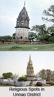
Attractions of Badarqa Harbans Village : One of the centres of tourism in Unnao District is the village of Badarqa Harbans that lies about 11 kilometres south of Unnao near Achalganj at a distance of 3 Km west of Unnao - Rae Bareli road. It was founded in 1643 AD by Raja Harbans, an official at the court of Shah Jahan, who received a grant of 500 Bighas from the Emperor in Pargana Harha. He built a fine house here with walls of limestone blocks to a height of about 500m, surmounted with turreted walls, on an elaborate frieze of red stone over the gateway, having alternately geese and elephants in pairs. A large hall of audience supported on carved pillars formerly stood here, but Asaf-ud-daula is said to have taken these pillars to help building Imambara at Lucknow.
Attractions of Baksar : Besides this, the travellers can also explore Baksar. It is the south most village of the district, lies on the left bank of the Ganga river, about 5 kilometres south of Daundia Khera and 51 km south-east of Unnao. The place is said to derive its name from a Sanskrit word Bakasram denoting the residence of Baka, a rakshas, who founded a town at the site of the present village. He lived here and erected a temple to Nageshwar Nath Mahadeo. Baka is said to have been killed by Lord Krishna. It is also said that Raja Abhai Chand, a Bais Rajput, conquered the place naming it after the shrine of Bakeshwar Mahadeo and made it its capital. Ram Bakhsh Singh, the Raja of Daundia Khera, who took an active part in the freedom struggle in 1857, was hanged here on a tree over a temple which was also blown up by the British. The ruins of the temple and several broken images are still found in the village. A bathing fair, attended by a large number of people, is annually held here on the full moon day of Kartika.
Attractions of Newal Town : The ancient town of Newal was occupied by Raja Nal, a local ruler and is traditionally associated with ancient site of `Alavi` of the Buddhist records and `Navadevakula` of Huien Tsang`s travel accounts. According to Buddhist literature, Lord Buddha stayed here for sometime and preached the gospel. The antiquity of the place is attested by the discovery of earthen black polished wares and other archaeological finds. A terracotta piece, in particular, representing `Aradhanarishwari,` is a rare specimen of its kind in India. It was found here and is displayed in the National Museum. The other interesting objects found here include Manshila Mandir, Davendihar and Mahadeo Phulwari.
The Budhawa Mangal fair is held here on the first Tuesday of the Chaitra month. Two other fairs are also organised here by the villagers. One of them is the Baboo Mian ka Mela. It is held on the first Tuesday of Chaitra, and the other fair is known as Shitala Devi which falls on the 8th day of the bright half of the same month.
Attractions of Daundia Khera : Also known as Sangrampur, Daundia Khera lies on the high bank of Morahi (Naurahi) river about 5 km west of the Unnao-Dalmau road and 29 km south of Purwa. About 13th century, Abhai Chand, a Bais Rajput, drove out the Bhars of Daundia Khera, after fighting a fierce battle. Abhai Chand gave the name of Sangrampur to the village where he fought the battle. Since then it formed the home of the great Bais clan of Rajputs. Ram Bux Singh, talukdar of the place and a descendent of Abhai Chand, was hanged here for participation in the freedom struggle of 1857.
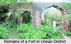 Attractions of Mohan : Mohan, a considerable village lies on the left bank of the Sai river, about 6 km east of Hasanganj and 38 km north-east of Unnao. Roads lead from this place to Malihabad in Dist. Lucknow on the east, Nawabganj on the south and Bangarmau on the north-west. During the days of the Nawabs of Avadh, it was an important town, of which many residents found employment in the court of the Nawab and earned large fortunes. The town was well known for its Unani Hakims, mimics and actors. To the south of the village near the Sai, is a high mound, supposed to be the remains of an ancient fort. On this mound is an old tomb of a Muslim saint.
Attractions of Nawabganj : Nawabganj lies on the Lucknow-Kanpur National Highway, about 20 kilometre North-East of Unnao. It was founded in 1842 by Amin-Ud-Daulah, the prime minister of Avadh, who built a serai or inn and a mosque which are still in good condition.
Attractions of Pariyar : Pariyar, which gives its name to a Pargana, lies on the left bank of the Ganga at a distance of about 23 km north-west of Unnao. In the vicinity of the village lies the Mahua Lake. Tradition has it that in the Treta yuga, Lakshmana at the behest of his brother Rama, accompanied Sita to her banishment to this place, which in consequence, came to be known as Parhar, a Sanskrit word meaning abandonment. With the passage of time, the name Parhar has been converted to Pariyar. It was here that Sita gave birth to Lava and Kusha who were trained in archery by Valmiki, and grew up to be accomplished warriors. They caught Shyambaran, a horse loosed by Lord Rama during Aswamedh Yajna arranged by him and this gave a signal of for a war between Rama and his Sons whom he did not know.
The village is said to have been founded in the 12th century by Himachal Singh, a Dikhit Thakur. The place houses two temples: Balkaneshwar Nath Mahadeo, said to have been built by Lava and Kusha and the other is of Janki.
Attractions of Patan : Patan lies on the road from Unnao to Allahabad via Achalganj, about 16 kilometres south of Purwa. The Rae Bareli-Kanpur branch of the Northern Railway passes by the village which has a Railway station, Takia. The village houses a temple dedicated to Lingeshwar Mahadeo, the Tomb of Muhabbat Shah, and an ancient mound ascribed to the Bhars. A large fair known as Takia - Ka - Mela, is held here on the 1st Thursday of Paus month, in honour of Niamat Shah. The latter was a disciple of Muhabbat Shah, a darvesh, who was a contemporary of Shuja-Ud-Daulah and Asaf-ud-daula, nawabs of Avadh.
Attractions of Safipur : Safipur lies on the Unnao-Hardoi road about 27 km north-west of Unnao. It is said to have been named after a dervesh Makhdum Shah Safi. He was buried here and the place assumed the name Safipur. Safipur forms the last resting place of several other darveshes also of whom the chief are Ifhamullah, Kudrat-ullah, Hafiz-ullah and Abdullah.
A famous mausoleum over the remains of the darvesh Safi was erected here. Small Urs fairs are held here on the 12th and 22nd day of Rabi-ul-awwal, 20th day of Jamat-us-sani, 12th and 14th days of Rajjab, 8th day of Ramzan and 14th day of Zilhaj.


