 Geography of Thoubal District is not entirely plain although this district is a part of Manipur valley. Many rivers flow through the district and many lakes dot its surface. In fact, all important lakes of Manipur are in this district. Important rivers that flow through the district are Imphal and Thoubal. Thoubal River originates in the hill ranges of Ukhrul and is an important tributary of the Imphal River. Imphal River rises in the hills of Senapati District and flows south. It forms the boundary demarcating line of Thoubal District on its north and the west. Other rivers in the district are Wangjing, Arong and Sekmai. These rivers originate in the hills of Ukhrul District. Arong River flows through Khangabok and falls into Kharung Pat. Wangjing River flows west via Heirok and Wangjing before joining Loushi Pat.
Topographical features of Thoubal District are also characterized with equitable and pleasant climate. Rainfall is relatively abundant and widespread. The rainy season starts in June with the onset of the south-west monsoon and last up to September. Winter season lasts from December to February. During the winter months light rainfall occurs under the influence of the north-east monsoon, March and October are by far the most pleasant months of the year. The summer months are never oppressive with the average maximum temperature fluctuates within 32 degree Celsius to 35 degree Celsius during April-June. The average minimum temperature recorded is 6 degree Celsius to 4 degree Celsius.
Geography of Thoubal District is dotted by a few hillocks and hills of low heights. Some of them are part of Khekman range, Mantak, Kwarok and Thongam Mondum-Punam. Of these, Punam hill has an elevation of 3310 feet above sea level. Geologically, Khekman range belongs to the Brail Series and Simsang formation. Good vegetation once covered these hills. But constant deforestation has made them barren and unattractive. Various types of trees are found all over the district. But the more commonly found varieties include Peepul tree. Various types of fruit-bearing plants also thrive in the districts. Important varieties are pineapple, pear, peach, Jack fruit, banana, mango, lemon, plum, guava, etc.
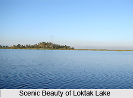
The south-western portion of Thoubal District is a low-land forming a part of the Loktak Lake region and this area has a number of shallow and rain fed lakes, the important ones being Kharung, Ikop, Pumlen, Lousi and Ngangou. On the northern portion there is Waithou Lake. These lakes drain into Imphal River. They provide good fishing ground for a variety of fishes in the region. Further, in spite of the rich vegetation of Thoubal District, due to the absence of forests wild animals are not found abundantly. Deer and Jungle fowl are some of the varieties found occasionally at present along the slope of eastern hills adjoining the district. But the lakes support a variety of wild birds such as partridge, snipe, duck, geese, etc. particularly in winter months.
Thoubal District is generally poor in mineral resources. The district has a number of places where red clay suitable for pottery is found. These are mainly available on the eastern side of the valley around Waikhong, Nongpok Sekmai, Thongjao, Chairel, etc. Naturally these areas are associated with pottery of very good types. Some qualities of low grade iron ore is found at Kakching.


