Introduction
 Chatra District forms the north-eastern parts of the North Chota Nagpur division of Jharkhand. The district is situated in the extreme northwest part of the state with its headquarters at Chatra. It is bounded on the north by Gaya District, on the east by Hazaribagh District and on the west by Palamu and Gaya District. The major portion of the Chatra district is covered by forest and it accounts for more than 60 per cent. The region has scattered settlement patterns. Previously, Chatra District was a sub-division of Hazaribagh District and was created as a separate district in 1991 under the notification government of Bihar. Chatra District occupies a total area of 3,706 sq kms.
History of Chatra District
 History of Chatra District states that this gateway of Jharkhand has a glorious past having an eminent chronological heritage. The land has been the silent spectator of the vicissitudes of the historical unfolding of human drama. It is stated that during Ashoka`s sovereignty (232 BC) the forest states too acknowledged the supremacy of the Magadhan Empire. It is said that Samudra Gupta marching through Chota Nagpur directed the first attack against the kingdom of south Kaushal in the valley of Mahanadi. Further, during Tughlaq`s reign, Chatra came in contact with Delhi Sultanate. The British rulers, for the first time, came in contact with these regions in 1769 AD.
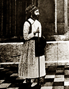
Chatra offers another fascinating chapter in the history of national movement in Bihar. The most important battle fought between the insurgents and the British in Chota Nagpur during the Sepoy Mutiny, 1857, was the `Battle of Chatra.` Chatra played a short but memorable small part on the historical canvas of the freedom movement
As per the history of Chatra District, it was previously the Divisional administrative headquarters of south Bihar. To the Muhammadan historians the whole of Chota Nagpur was in the tract which they knew as the Jharkhand or the forest country. It remained practically independent through out the Turko-Afghan period (1206 to 1526 AD) in India.
After the death of Aurangzeb in 1707 the Mughal Empire almost collapsed and Muhammad Shah was the Regent of the Mughal Empire from 1719 to 1748. Sir Buland Khan the then governor of Bihar who attacked Chota Nagpur in 1724. The new Governor of Bihar Aliwardi Khan advanced towards kunda in 1734 after defeating the rebellious zamindars of Tikari (Gaya). He attacked the Chatra fort and the fort was demolished.
The year 1765 AD opens a new epoch in the history of Chota Nagpur as on 12th of August 1765. Emperor Shah Alam II granted the Diwani of Bengal, Bihar and Orissa to the East India Company. As Chota Nagpur forms a part of Bihar, British East India Company was entitled to receive tribute or Ramgarh, Kharagdiha, Kendi and Kunda. Further, in the year 1799 a Munsif was appointed for the first time and was stationed at Chatra. Ranchi settlement, Report indicates that in the year 1778, an establishment of five companies was ordered to be stationed at Chatra. Governor General in Council thought that the district be continued to remain at Chatra and thus Chatra continued to be the district headquarters of Chatra District or Ramgarh Zila from 1771 to 1833 AD.
On 12th of December, 1912 Bihar and Orissa and Chota Nagpur were separated from Bengal by a Royal Proclamation to form a separate province. In the year 1914, Chatra was made a sub-divisional headquarters of the Hazaribagh district. Orissa was separated from Bihar in 1936. In 1991, Chatra became a separate district of Jharkhand.
Administration of Chatra District
Administration of Chatra District comprises one sub-division, ten development blocks, 125 Panchayats and 1479 Revenue Villages. However, there is only one municipality - that is at the district head quarters of Chatra. There are nine police stations in Chatra District. A full-fledged judgeship has started functioning from 16th of June 2001 under District and Session Judge, assisted by Additional District Judge, Chief Judicial Magistrate and Judicial Magistrates. The forest portion comprises four territorial divisions (North, South Chatra, Koderma and Hazaribagh West) and two state trading divisions.
Culture of Chatra District
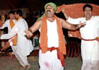 Culture of Chatra District is a reflection of the various colourful fairs, festivals, arts, crafts, traditional and cultural values of the people. There is no specific and recognized language used in this district of Jharkhand. Generally spoken dialects are Magahi, Nagpuri, Khortha. But these dialects are also not in a pure from; rather in a mixed form. Generally people of Chatra District understand, speak and write Hindi language and Urdu language. Tribal population in Chatra District is not very significant but they use Sadri or Nubndari (tribal language) among themselves. Chatra District has been a seat of religious acceptance from time immemorial. It is mainly famous for `Shakti` cult. The noted seat of this cult is to be found in Hunterganj and Itkhori blocks. Further, throughout the year various festivals and fairs are organized in the district.
Some of the popular fairs of the district are as follows -
Kunda Mela in Pratappur: This mela is held at the time of Falgun Shivaratri and is marked by a big sale of cattle.
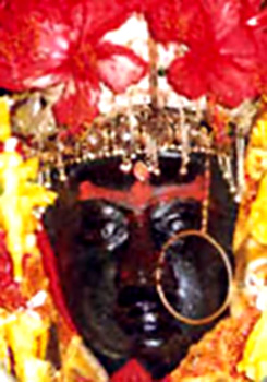
Kolhua Mela in Hunterganj: It is an ancient fair held twice in a year during Magha Vasant Panchami and Chaitra Ram Navami respectively. There is a beautiful lake and ancient temple of Goddess Kali on the top of the hill. Its origin is not known. It is only a religious fair.
 Chatra Mela: This mela is said to have started from 1882 and is principally a cattle fair held during Durga Puja.
Kundri Mela in Chatra: The probable year of its origin is 1930 and is held on Kartik Purnima and is principally cattle fair.
Kolhaiya Mela in Chatra: The probable year of its origin is 1925. It is held on Magha Vasant Panchami and is principally cattle fair.
Tutilawa Mela in Simaria: The probable year of origin is 1935 and is principally a cattle fair held on Falgun Purnima.
Lawalong Mela: The probable year of its origin is 1880. It is held at the time of Aghan Purnima and is one of the biggest cattle fair of this district.
Belgada Mela in Simaria: The probable year of its origin is 1920 and this is also cattle fair held in Baisakh Purnima.
Bhadli Mela in Itkhori: There is an ancient temple of Goddess Kali and Lord Shiva. It is considered as a religious gathering on Makar Sankranti.
Sangharo Mela in Chatra: It is held in Sawan Purnima. The origin of this fair is not known.
People of Chatra District have strong religious beliefs. Temple of Bhadrakali, Kauleshwari Devi Temple and Royal Mosque located in this region give a foretaste of the inherited beliefs prevalent in the region. Important festivals celebrated in the district are Holi, Diwali, Dussehra and Ramnavami. Other festivals like, Vasant panchami, Chath puja, Jityya Bhaiya Duj, etc. are also celebrated in this district. Important festivals of Muslim communities are Id-Ul-Fitr, Baqrid, Muharram, Shabe-barat. Specific festivals of the tribes are Karma, Manda, Sarhul, Jani shikar, etc. In Karma festival non tribal communities also participate.
Folk music is popular in the rural areas of Chatra District and is usually presented on important festivals, marriages and other occasions. Particularly the tribal dances are rhythmic. All these give a glimpse of the vibrant culture of Chatra District.
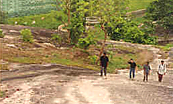
 Tourism in Chatra District includes options of exploring infinite variety of wild life and greenery. Chatra District is defined as the gateway of Jharkhand. This district is abundantly rich with scenic picnic spots, fountains, waterfalls, and temples and last but not the least it is also rich in flora and fauna. The enchanting beauty of the forests of Chatra District has everything that a nature lover would ever want. Some of the major tourist spots of Chatra are mentioned below.
Pilgrimage Tourism in Chatra District -
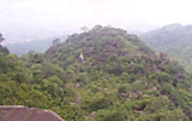
Kolhua Hill: Kolhua hill lies about 6 miles south east of Hunterganj. At Hunterganj one has to cross the Lilangen River. The height of the hill is 1,575 feet and from the top one can find an excellent view. The top of the hill is quite distinctive and is known as "Akash Lochan" (Sky Eye). There are some ancient temples, the most important of which is a temple of Goddess Kali known as `Kauleshwari Devi`. On the occasions of Vasant Panchami and Ram Navami, a large number of pilgrims flock to the hill top for worship. Further, the trek to the top of Kolhua hill on the temple of Kauleshwari Devi is quite steep and there are no steps. There is a big tank near the temple with good water.
Barura Sharif: There is a shrine of Amir Ali Shah at Barura Sharif situated at a distance of 12 kms from Block Headquarters of Pratappur. This Shrine has been constructed at the height of about 10 feet from the river bank. A small seasonal river flows surrounding the Shrine. One has to cross seven small rivulets to reach Barura Sharif; hence locally these ravines are together named `Saat Bahini` (Seven Sisters) in this region. The Shrine has a quiet and picturesque look. It is very attractive. One would love to have a view of the small ravine from the height of the Shrine. `Urs` (annual fair) is held here with pomp and pleasure on the eve of Chaitra Navami.
 Leisure Tourism in Chatra District -
Kunda Cave: The ruins of old Kunda palace are still found at a distance of about three or four miles from the present Kunda village. The place might have been created either towards the end of 17th or beginning of the 18th century AD. The walls are in a very dilapidated condition. The cave is a hollow made at the base of a part of the hill, not so high. The entrance into the cave is very narrow. There is a central hall inside the cave, not so high. The small hollows connected with their only passage with this central hall, are completely dark. There is a big Shivlinga just at the middle of one of the hollows.
Nature Tourism in Chatra District -
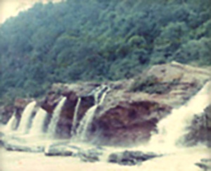
Tamasin: It is an attractive beauty spot of Chatra situated on the north-east at the distance of 26 kms. There is a big water reservoir and it is famous for the image of Goddess Bhagwati. Here one can enjoy the scenic beauty of the gorgeous water fall. This area is full of mixed forests having high trees making the area dark even in the daylight. Tamasin is mainly famous for a very beautiful waterfall.
Bichkiliya: It is `Dah` or water reservoir on the bank of river Niranjana (Lilajan) at a distance of 11 kms from Chatra in west. It is also a nice picnic spot.
Duari: It is also known as Balbal Duari situated at the distance of 35 kms in the East of Chatra district on Gidhaur -Katkam Sandi Road. It can be reached from Hazaribagh also. The road is motor able and one can visit this directly form Chatra. During rainy season it is difficult to travel but it is pleasant in winter and summer. There is a hot spring in the bed of river Balbal near the village i.e. Duari. The water is supposed to have curative effect on skin diseases. As in Rajgir here people flock to have hot bath for obtaining remedial effect .In the same way on Makar- Sankranti people gather here in a large number to have a holy dip. The sight is also charming & delightful.
 Khaya Banaroo: This notable picnic spot of Chatra is about 10 kms from the district headquarters on the south-west of the town. The woods are lovely, dark and deep. The scenery is splendid in all its exquisitely green sylvan beauty. The Banaroo (Dah) reservoir or stream cuts its way through the rocks, and at places, it has cut terraces with balconies out of stone walls on its banks. The deep gorge with numerous shapes in the stones that form the wall of the two sides of the gorge is a rare sight. At places, it seems as if the portions of trees have been transferred into rocks. The river bed is enchanting.
Keridah: A beautiful picnic spot situated at a distance of 8 kms from Chatra town on the north-west portion.
Maloodah: It is another beautiful water fall at the distance of about 8 kms on the west of Chatra. It has been cut in semi circle with steep walls. It gives a soothing experience.
Dumer Sumer: It is also another popular beauty spot of Chatra situated on the north at the distance of 12 kms.
Goa: It is a beautiful water fall at the distance of 6 kms on the west of Chatra on way to Maloodah. Its height is around 30 ft. On all the three sides there are rocks and in middle there is a reservoir. It is the nearest picnic spot of Chatra District.
Bhaduli (Bhadrakali): It is 35 kms on the east of Chatra and 16 kms west of Chauparan connected with Grand Trunk Road. It is situated on the bank of Mahanadi River surrounded by hills and forests. There is a water reservoir which has a natural beauty of its own. People flock to watch its eternal beauty on Kartika Purnima, a festival after Chath.
Gogri: It is a water fall and a steep descent leads to its foot. It is 4 miles west of Chatra on the way to Maloodah.
Thus, Chatra District is full of rocks and ravine, fountain and flora, deep and dense forest, that offer a mesmerizing tourism experience to the travellers.


