 Howrah is one of the administrative districts of the state, including the city itself and the adjacent areas. The city came to be existed functionally as a separate administrative unit in the end of 1937. The second largest city of West Bengal lies along the west bank of the Hooghly River. As far as the history is concerned the present district of Howrah has owed its name from the name of a village called "Harari" existed in the 18th century.
Howrah District
Howrah District is essentially an industrial district serving as the major railroad transportation hub.
Introduction
Howrah is one of the administrative districts of the state, including the city itself and the adjacent areas. The city came to be existed functionally as a separate administrative unit in the end of 1937. The second largest city of West Bengal lies along the west bank of the Hooghly River. As far as the history is concerned the present district of Howrah has owed its name from the name of a village called "Harari" existed in the 18th century.History of Howrah District
 Howrah District, said to be the twin of Kolkata, has a rich history that dates back almost 500 years. It is the smallest district in West Bengal situated between 22 degrees 12 minutes and 22 degrees 46 minutes morth latitude and 88 degree 22 minutes and 87 degrees 50 minutes east longitude. It is bounded on the north by the Arambagh and Serampore subdivisions of the Hooghly district; on the east by Kolkata and the Barrackpur, Alipur and Diamond Harbor subdivisions of the 24-Parganas district; on the south by the Tamluk subdivision of the Midnapur district; and on the west partly by the Tamluk and Ghatal subdivisions of the latter district and partly by the Arambagh subdivision of the Hooghly district. The boundaries are partly natural and partly artificial.
The name itself is possibly derived from a village named Harirah which was located in or about the site of modern day Howrah City. Venetian explorer Ceasare Federici was the first European who mentioned a place called Bator in his journal in 1578 AD which is identifiable with the modern day place around the Howrah City. The Bengal Council of the British East India Company, on the accession of the Emperor Farruksiyar to the throne of Delhi in AD 1713, sent a deputation to him praying for a settlement of the villages `Salica` (Salkia), `Harirah`(Howrah), `Cassundeah`(Kasundia), `Ramkrishnopoor` (Ramkrishnapur), and `Battar`(Betor) to the west of Bhagirathi river and once the settlement was made in favour of the British East India Company the places were quickly adopted as exit and entry point of sea faring business hubs and the modernisation of Howrah city as we know it now, began.
The Howrah Railway Terminus came up in 1854 and in 1862 the first municipal administration started functioning though the modern day Corporation as we see it now came into being in 1980 when the Howrah Act, 1980 was implemented. It was transferred from the Burdwan Division to the Presidency Division under Government of West Bengal Notification No. 999-G.A. dated March 4, 1963.
Demography of Howrah District
As per the demographic survey of 2001, Howrah comprises of about 1,008,704 population, of which 54% consists of male and 46% females. Howrah has an average literacy rate of 77%, which is even more than the national average. About 81% male and 73% of female are literate. About 9% of population is below 6 years of age.As the economy is prevalently industrial, majority of populace draw living from the industries. Only 30 % of people engaged in cultivation. The eminent demographers have pointed out that the majority of areas have urban set up. Till 1998, about 755 villages facilitated with electricity. There are about 28 hospitals and 59 health centers throughout the district. Primarily a Hindu District, some Muslims are also found locally. Though Bengali is largely spoken, the local Muslims speak Hindi and Urdu.
Education of Howrah District
 The education in the Howrah district has a sound basis since its advent. According to the unexcavated fact, the Sanskrit Literature once attained popularity. The relics of the Sanskrit "tolls" are found in the extensive areas of Bally, Belur and Amta. However the existing "Chatuspathis" are provided with Government aid for the promotion of the Sanskrit language.
The Baptist Missionaries initiated the convent education in Howrah. Recently there are several schools affiliated to both West Bengal and I.S.C.E and C.B.S.E. Narasimha Dutta College was the first college, established in 1923 provide the courses of B.A, B.S.C and B.COM. Presently there are clusters of colleges in the district to provide these general courses, of which some are Government undertaken and some are private enterprises.
The first Girls` College in Howrah, which initiated the higher education of the girls here, was brought under the jurisdiction of Calcutta University in the year of independence.
The vocational trainings are also emphasized to cope up with the rapidly changing world. The vocational learning also ensures the educational development. Presently there are some drama and music schools of superior quality in Howrah.
Culture of Howrah District
Howrah is mainly populated with the Hindus; hence the culture of the land essentially follows the Hindu cult. The festivals and the lifestyle in the district utter the Hindu Culture prevalent in the region.The people of the Howrah region intensely believe in the divine power of Devi Chandi.Even there is a common belief that the land has been formed by the blessings of Devi Chandi. However people in the interior zone also worships certain demigods. Rashmela of Uluberia, Durga Puja Mela of Fort Gloster, fairs in Kalyanpur, Baniban and Bagnan on the occasion of the Gajan etc. are some of the fairs representing the prevalence of the Hindu Culture.The culture of "Para" or neighborhood is very common in the region. The leisurely chat or locally called "Adda" is popular here. Rice and fish are the traditional favorite.Howrah, an industrially developed district represents an urban set up with a sound basis of socio-economic and educational foundation.
Economy of Howrah District
 Howrah is economically prosperous and in the recent times it can compete with the other economically affluent district of the state. The economy of Howrah is predominantly industry dependent. Recently Howrah witnesses a lot of industrial proposals in its core.
The location of Howrah is congenial for the economic growth of Howrah as well as the state. The city connected with Kolkata through Howrah Bridge (Rabindra Setu), Second Hooghly Bridge (Vidyasagar Setu) and Vivekananda Setu as well, constitute an effective road network. The Howrah station, one of the major rail stations in India, serves both Kolkata and Howrah. Hence the industrial development in Howrah is mainly due to the positional significance of the district.
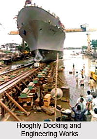
The district is making economic progress with the mushrooming of both the small & large- scale industries. Salkia, in Howrah is the abode of the ship making industry in India. Hooghly Docking and Engineering Works (Salkia), Shalimar Works (Shibpur), Port Engineering Works (near to the Botanical Garden) etc are the traditional industries in the districts, established in the British regime. These industries supports the domestic economy and at the same time accounts for the large quantity of export while enhancing the overall economy of Howrah.
Though the market of jute is not pretty comfortable, still now there are about 20 jute mills here providing an ample scope of employment, thereby supporting the local economy of Howrah to a large extent. The first cotton mill of India had been established in Howrah in 1817, which is still in operation. Though the market of the jute and the cotton products produced in India, these small-scale industries support the domestic requirement providing economic stability to a group of individuals. However as the prospects of the jute industry is not at ease, the majority of the jute industries have been closed. The jute and cotton textile here are the government concerns, which are instrumental to grant the economic aid to the extremely poor folk.
T The small-scale industries in Howrah are Government undertaken, which instead of being participating in the export business mainly supports the local economy by providing subsidiary parts to the domestic industries and offering employment to the natives. Ganges Rope factory at Shibpur, Shalimar paints, Eastern Railway Carriage and Wagon Workshop etc. are the factories of the above kind.
The key reason behind the expansion of the industries and their successful trading in the adjacent parts and even in the abroad was the construction of the Howrah Railway Terminus in 1854 and its well-organized network upto Mogalsarai.
The West Bengal State Government is planning to revitalize the industrial scenario of Howrah, thereby inducing rapid economic progress. With the collaboration of Department of International Development (DFID), a project for the economic development of Howrah is adopted. Recently the industrial proposals like the kona truck express and the logistic hub have been taken up in the district of Howrah. New industrial proposals in the town along with the reallocation of the foundry products have stimulated the economic upliftment of the district.
The economy of Howrah is no less supplemented by the agriculture. The regional topography, marked with uniform homogeneity, made up of fertile alluvium carried by the Bhagirathi in the eastern border and the Rupnarayan on the western border. The conducive landscape and the tropical climate augment the agricultural growth. Near about 75% of land is cultivated. Though rice is the principal crop, it mainly meets the local food demands. The pulses, oilseeds and potato cultivation mainly support the agricultural economy. The majority of these products are exported to the neighboring areas, which supports the economy greatly.
Tourism in Howrah District
 Tourism in Howrah district is replete with visits to places of historical and religious. These various places located in the district of Howrah are among the most visited places in all of West Bengal. Once known as the `Manchester of Bengal`, the district is home to a number of tourist attractions such as the Howrah Bridge, the Botanical gardens, Belur math etc. Some of the most visited places of tourism in Howrah district are discussed below.
Leisure tourism in Howrah district : Of the various places of tourist interest located in the district of Howrah, the Howrah Bridge or Rabindru Setu is the most famous. The old Howrah Bridge was opened in 1874 and handed over to the Port Commissioners who managed and maintained it. It was designed by the late Sir Bradford Leslie. It extended over a total length of 1528 feet between centres of abutments and provided a 48 feet roadway and two 7 feet footways.
The most novel feature was the removable section which when floated out gave a 200 feet clear opening, with a head room of 22 feet, were also provided for smaller crafts. The adjusting ways or shore spans, one at each end of the bridge, consisted of three 160` feet long bow string girders.The traffic between commercial Kolkata and industrial Howrah having enormously increased during the first quarter of the 20th Century, the old bridge was quite insufficient and it was decided to build a new one. The shifting mode of the Hooghly River was dangerous for either a cantilever or a suspension bridge and hence a bridge was designed as a sort of combination of the both. It is however known as and reputed as a cantilever bridge and is the third largest bridge of its kind in the World having an over-all length of 2150 feet with a single span of 1500 feet.
Howrah Bridge : The new Howrah Bridge was designed by Rendell, Palmer and Tritton, consulting Engineers. It took 8 years to complete the bridge and 26,500 tons of steel including 18,200 tons of high tensile quality were used. The total cost of construction of the land and all ancillary works, amounted to Rs. 3.33 crores. It is interesting to note that the bridge expands about 4.8 inches during the heat of the day and contracts an equal length in the cool of the night. Another peculiarity of the bridge is that it bends over slightly in strong winds. The framework has also been built to withstand earth-quakes, as Calcutta lies in a seismic zone. The height of the Bridge at the supporting towers on the both ends is 300 feet. Each tower has a constant width of 11 feet. The entire structure is laid on main piers of re-enforced concrete monoliths with steel ceiling edges. The piers are among the largest in the world. The monoliths and grinders on the Kolkata side are 103 feet deep and on the Howrah side it is 88 feet deep. These monoliths are the heaviest in the world. One can have a bird`s eye view of Howrah Station and glimpses of the cities of Kolkata and Howrah along the banks of the Hoogly River standing in the middle of the bridge.
Second Hooghly Bridge : The Second Hooghly Bridge or Vidyasagar Setu is another landmark spot in Howrah. It opened to traffic in 1922 and is one of the finest products of modern technology and architecture. It is intricately connected with the cities of Kolkata and Howrah by a series of over-bridges and situated at a distance of 1.5 k.m. southwards of Rabinrda Setu.It is erected on only four pillars and hung on 121 number of iron ropes. The bridge is 458 metres long and 115 metres wide. One can have a glimpse of a large part of Kolkata standing in the middle of the bridge. The beauty of the bridge and its background is largely utilized by the Film Industries of India for shooting purposes.
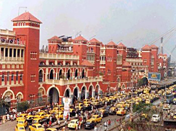
Tourism in Howrah district would be incomplete without a mention of the Howrah station. Developed towards the early part of the twentieth century, it has become one of the most important points of transit for passengers as well as the movement of goods in the country. The station building completed a 100 years in 2006. Howrah is the terminus of the first Indian Railway system namely East Indian Railways. A survey for the East Indian Railway was taken up in 1845 and construction began in 1851. The section of the Railways, a Broad gauge railway was opened in 1854 from Howrah to Hooghly. After construction of the first Howrah Bridge in 1874, the Howrah Station was remodeled and improved. Howrah station has now a large imposing building facing the river with clock Tower and twenty long platforms for the passenger trains and three for the goods trains.
Botanic Gardens :
The Indian Botanic Gardens are a much visited place by both tourists and locals alike. Previoulsy known as the Royal Botanic Garden, it lies along the banks of the river Hooghly. It covers a total area of 285.05 acres of land. The Botanical gardens adjoin the compound of the Shibpur engineering college on the south. This green belt is considered to be the lungs of the highly industrial and urbanized city of Howrah. The greatest attraction of the garden is the Great Banyan Tree. The size of the tree is so huge that it resembles more of a forest than a single tree. The tree has sent down innumerable roots from its branches vertically to the ground and the roots have grown thick and stout to bear the appearance of having many trunks. The striking development of the aerial roots from the branches is the peculiarity of the Banyan tree. Besides the great Banyan Tree, there is a fair collection of rare indigenous and exotic plants, beautiful Amazon lilies, climbing plants, varieties of palm, delicate orchids and all sorts of large trees - mahogany, teak, walnut etc. Also found here is a nursery (not open to the public), a conservatory, a palm house, a Herbarium and an Orchid Conservatory. There are certain monuments and buildings which are also found in the Botanic gardens. These are - Wallich`s monument, Kyds` Monument, Griffiths Monument, Jack`s Monument, Kurze`s monuments etc.
Panitras-Samtaber : Panitras-Samtaber is the home of the immortal Bengali novelist Sri Sarat Chandra Chattterjee. Though he was a writer of Bengali literature, his great novels and short stories dealing in human emotions are translated in almost all major languages of India. His two-storied dwelling house is situated at Panitras or Samtaber village on the bank of the Rupnarayan River in a sort of perfect lonely village atmosphere of Bengal. The building is now preserved as a museum where mementoes of Saratbabu like table, chair, chappals, stick, bed, writing tables etc are kept, apart from his works (books), some manuscripts and personal letters. Saratbabu spent twelve years (1926-1938) of his literary life in this place before permanently settling at Kolkata. During this period he created some of his finest stories and novels such as Abagir Swarga, Bamuner Meye, Palli Samaj, Ramer Sumati, Mahesh, Srikanta(4th part).
Bengal Engineering College : The Bengal Engineering College at Shibpur is a premier Engineering College in the state and one of the best engineering colleges in the country. It is situated on the banks of the River Hooghly at the south-eastern border of the town and the north of the Indian Botanic Garden. The site, comprised of about 50 acres of land, was originally included within the compound of Indian Botanic Garden and selected by Bishop Middleton, the first Bishop of Kolkata for Bishop`s College. The main building of the Engineering College - a Gothic structure, was also erected for the old Bishops` College. The land comprising 62 Bighas was presented by the Marquis of Hastings and money was funded by the Foreign Bible Society and the Church Missionary Society. The foundation stone was laid in 1820 and the college was opened in 1824. The college is upgraded to the status of a Deemed University in the recent past with facilities of learning of almost all the trades of engineering.
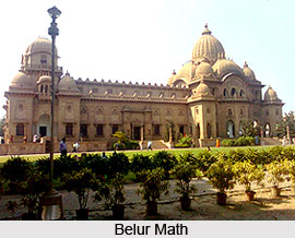
Pilgrimage Tourism in Howrah district : Belur Math is situated just outside the boundary of Howrah Municipal Corporation on the north and stands on the West Bank of the river Hooghly. It was founded in 1897 by Swami Vivekananda, the great savant of India, and other disciples of Sri Ramkrishna Paramhansa, who is regarded by the Hindus as an incarnation of God and occupies a place of great honour amongst the religious leaders of the world. A magnificent temple has been built at a great cost by the munificence of two pious American ladies, Miss Helen Rubel and Mrs Auna Worcester. The breadth of the shrine is 100 ft and its length, including the prayer hall, is 233 ft. On a marble pedestal in the shrine is a marble statute of Sri Ramkrishna in his familiar Asana. The prayer hall is 152 ft. long, 72 ft. wide and 48 ft. high. The math is the headquarters of the Ramkrishna Mission, a society established for the propagation of the orthodox Hindu faith chastened with modern outlook. There is also a large Museum inside the Math depicting the lives of Sri Ramkrishna and his close disciples. The temple and the Math is visited by countless people, most of whom are religiously inclined, to celebrate the birthday anniversary of Sri Ramkrishna (18th February 1836) in February when a fair is held there. The place also attracts large number of visitors from Kolkata and abroad every day, especially on Sundays and holidays.
Recently updated articles in States of India
History of Thissur District
Early History of Thissur District explains flourishing of the port cities. Now these port cities are transformed into archaeological sites.
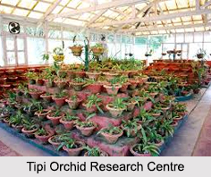
Tippi Orchid Research Centre, Arunachal Pradesh
Tippi Orchid Research Centre in Arunachal Pradesh is renowned for its rich collection of exotic and endangered orchids. Surrounded by lush rainforest...
Tourism in Nashik District
Pilgrimage tourism in Nashik district involves visiting the various places of Hindu and Jain worship located here. Some of the holiest sites for Hind...
Mangadu, Kerala
Mangadu in Kerala’s Kollam district is a significant megalithic site known for its urn burials, cist burials, menhirs, and stone circles. Excavations...
Devaswom
History of Devaswom is not very ancient and can be dated back to late seventeenth century.
Related articles in States of India

East Indian States
East Indian States comprises of Bihar, Jharkhand, West Bengal, Odisha and also the Union Territory of Andaman and Nicobar Islands. It defines the cult...

Purnia District in Bihar
Purnia District is located in Bihar and extends from River Ganga to Nepal. The district has a rich Hindu history and glorious past.

Hooghly district
Hooghly District along the bank of the river Hooghly is one of the principal trading ports of West Bengal.

Geography Of Chittoor District
Geography of Chittoor district is spread along the topography of the land which is divided into two natural divisions; Chittoor has a dry and healthy...

Districts of West Bihar
Districts of West Bihar is comprised of medieval monuments that were built by the different governors of Mughal era.