 Dhemaji District of Assam is situated in the remote corner of north eastern region of the country on the north bank of Brahmaputra River. This district is bounded by the hilly ranges of Arunachal Pradesh in the north and in the east, by the Lakhimpur district in the west and by the Brahmaputra River in the South. The district covers a total geographical area of 3237 sq kms. The district headquarter is located at Dhemaji. This district is basically plain land lying at an elevation of 104 metres above the sea level.
History of Dhemaji District
Historical accounts of Dhemaji District suggest that in 1240 A.D. the Ahom king, Chow Chukafa founded his capital in the Dhemaji District. Initially, the present geographical area of Dhemaji District was a part of the then Lakhimpur District of the state with its headquarters at Dibrugarh. Dhemaji was declared as a sub-division in the state in 1971 and finally, in 1989, it was declared as an autonomous district of Assam including Jonai Bazar and Dhemaji sub-divisions. The origin of the name of this district was a result of one such mythological and hypothetical belief. According to the most popular belief, there was a river, which caused unanticipated flood because of frequent change in its course very frequently. As a result, the river was believed to be an evil spirit. In Assamese version, the words flood and playing are known as `Dhal` and `Dhemali` respectively and thus, the area where flood is a persistent phenomenon can be called as a `playground for flood`. It came to be known as `Dhal Dhemali` in Assamese Language. Over the years, the word `Dhal` was removed and the word `Dhemali` came to be known as `Dhemaji`.
Geography of Dhemaji District
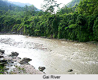
 Geography of Dhemaji District is vastly spread over plain land with small hillocks. Brahmaputra River flows from east to west in the southern part of the district. Different tributaries like Dihingia, Jiadhal, Moridhal, Telijan, Kaitongjan, Laipulia Nadi, Kapurdhuwa, Sissi, Gai, Tangani and Guttong originating from Arunachal Pradesh in the north. The district is vulnerable to floods and occurrences of floods are a regular feature, which causes lots of damages. The soil of the district is mainly alluvial and sandy. The riverbeds are generally higher than the level of land.
Climate of Dhemaji District
The climate of Dhemaji District is per-humid characterized by high rainfall, mild summer and winter and falls under cool to warm sub zone. It is moderate and it receives rainfall on an average at 3000 mm with North East Monsoon contributing a major share. The annual rainfall of the district ranges from 2600 mm to 3200 mm. Rainfall generally begins from April and continues till the end of September. The relative humidity of Dhemaji District varies from 90 per cent to 73 per cent. The rainfall generally increases from south east to northeast.
Administration of Dhemaji District
Administration of Dhemaji district is mainly divided into two sub-divisions, Dhemaji and Jonai Bazar, comprising a total of five blocks (Dhemaji, Sissiborgaon, Morkongselek, Bordoloni and Machkhowa) and around 1150 revenue villages. Deputy Commissioner is in charge of the entire administrative set-up of Dhemaji District.
Demography of Dhemaji District
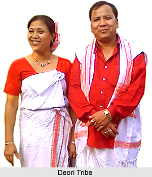
Dhemaji District includes a huge range of Scheduled tribe and Scheduled Caste population. The average density is 176 per sq km. However, the urban population rate is quite low, which indicates the predominantly rural character of the district. The literacy rate in the district is average. Moreover, in Dhemaji District, there is a huge chunk of Other Backward Classes (OBC) population comprising of Ahoms, Chutiyas, Konches etc. The Schedule tribes include Mishing tribe, Bodo Tribe, Deori Tribe, Lalung Tribe and Hazongs. The major languages spoken by the people of the region are Assamese Language, Mishing, Bodo Language and Bengali Language. The principal religion followed by the people is Hinduism. However, Christianity and Islam are also practiced here.
Economy of Dhemaji District
Economy of Dhemaji District is mainly based on agriculture. Agriculture is the main occupation of the people of this district. Paddy is the major agricultural crop cultivated here. Mustard is the major oil seed crop grown in Dhemaji District. Potato and pulses are other major crops grown in the district. Fruits and vegetables are also cultivated on a moderate scale. Apart from Agriculture and allied activities, Sericulture activity is gaining ground in Dhemaji District. Industrial activity is not prominent in the district and no major industrial units exist in the district.
Tourism in Dhemaji District
Dhemaji District offers numerous tourist attractions to its visitors. It offers unending exploring options to the travellers. The significant places of interest of this district attract a number of tourists across the globe. Some of the popular tourism spots of Dhemaji District are Malini Than, Gerukamukh, Ghuguha Dol, Maa Manipuri Than, Rajgarh, Garakhia Than, etc. It attracts the travellers through its natural charm and beauty.
How to Reach Dhemaji District
Dhemaji District can be accessed through several modes like roadways, waterways and railways. National Highway number 52 passes through this district. It extends up to Jonai Bazar and is only around 12 hours journey from Guwahati. Regular bus services also ply from Tezpur and Nagaon. Railway communication is also available from Guwahati. One can also reach this district by Ferry service that is available from Dibrugarh.
Thus, this administrative district of Assam houses a huge tribal population having their own culture and traditions.