The geography of Andhra Pradesh includes the details of its location, climate and other geographical details of this Indian state in south India. Andhra Pradesh is India`s fifth largest state (in regards to area) spreading over an area of around 2,76,754 sq. kms.
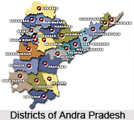
 The location of Andhra Pradesh is calculated to be between 12° 41` and 22° East longitude and 77° and 84° 40` North latitude. It shares common boundaries with Madhya Pradesh and Orissa to the north, the Bay of Bengal to the east, Tamil Nadu and Karnataka to the south and Maharashtra to the west. The state also forms a key link between the north and south of India. The state is divided into 23 districts for administrative purpose. Considering the geographical position, Andhra Pradesh can be divided into three distinct regions, namely Kosta (Coastal Andhra), Telangana and Rayalaseema.
 Telangana lies west of the Ghats on the Deccan plateau. The Krishna River and Godavari River rise in the Western Ghats of Karnataka and Maharashtra and flow east across Telangana to empty into the Bay of Bengal in a mutual river delta. Kosta occupies the coastal plain between Eastern Ghats ranges that run all along the length of the state, and the Bay of Bengal. Rayalaseema is situated in the southeast of the state on the Deccan plateau and is nestled in the basin of the Penner River; it is separated from Telangana by the low Erramala hills and from Coastal Andhra by the Eastern Ghats.
The moderate climate of Andhra Pradesh throughout the year is due to its proximity to the sea. The inhabitants of the state face a hot summer but after the rain begins in the middle of June, there is a lowering in the temperature as humidity takes over. Summer season begins from mid-April and continues till mid-July; the rainy season starts soon after.
Andhra Pradesh receives most of its annual rainfall from the southwest monsoon and northeast monsoon. The southwest monsoon begins in the second week of June and lasts till September while the northeast monsoon begins between October and November. The coastal belt of Andhra Pradesh experiences heavy rains during the northeast monsoon and is also prone to cyclones causing massive damage to residential areas and to standing crops. The rainfall decreases from north to south in the state. Northern parts of Andhra Pradesh receive heavy rainfall from the southwest monsoon while the southern areas like Rayalaseema experience more rainfall from north-east monsoon.
The state experiences a mild winter in December; however the temperature does not usually go below 16 °C. The hot season causes troublesome environment in the months of April and May when it could raise up to 40 degrees or even higher. The geography of Andhra Pradesh depicts the state to be a convenient location in India that can be easily reached and the climate is pleasant enough to enjoy.


