Home > Travel > States of India > Geography of Jammu & Kashmir
Geography of Jammu & Kashmir
Jammu and Kashmir is encompassed by valleys. Some of the dominant valleys of the state are Kashmir Valley, Tawi Valley, Chenab Valley, Poonch Valley, Sind Valley and Lidder Valley etc. Jhelum River is the only major Himalayan River which flows through the Kashmir valley. Indus, Tawi, Ravi and Chenab Rivers are the major ones flowing through the region.

Share this Article:

Geography of Jammu & KashmirStrategically located Jammu and Kashmir State constitutes the northern most extremity of India. Situated between 32.17 degree and 36.58 degree north latitude and 37.26 degree and 80.30 degree east longitude, the total area of the State is 22,22,236 sq. kms including 78114 sq kms under the illegal occupation of Pakistan and 42,685 sq kms under that of China, of which Pakistan illegally handed over 5130 sq kms to China.

The State is bounded by Pakistan, Afghanistan and China from the West to the East. The State ranks 6th in area and 17th in population among the States and Union Territories of India. The State consists of 14 districts, 59 tehsils, 119 blocks, 3 municipalities, 54 towns and notified area committee, 6477 inhabited villages and 281 uninhabited villages. It has four geographical zones:
Geography of Jammu & Kashmir1. Sub-mountain and semi-mountain plain known as kandi or dry belt`
2. The Shivalik ranges;
3. The high mountain zone constituting the Kashmir Valley, Pir Panchal range and its off-shoots including Doda, Poonch and Rajouri districts and part of Kathua and Udhampur districts; and
4. The middle runs of the Indus River comprising Leh and Kargil.

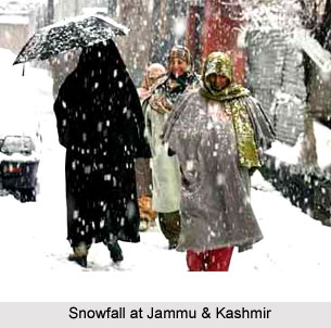
The State of Jammu and Kashmir is the northern most state of India comprising three distinct Climatic regions- Arctic cold desert areas of Ladakh, temperate Kashmir valley and sub-tropical region of Jammu. There is a sharp rise of altitude from 1000 feet to 28250 feet above the sea level within State`s four degree of latitude.

Climate of Jammu & Kashmir
The climate varies from tropical in Jammu plains to semi-arctic cold in Ladakh with Kashmir and Jammu mountainous tracts having temperate climatic conditions. The annual rainfall also varies from region to region with 92.6 mm in Leh, 650.5 mm in Srinagar and 1115.9 mm in Jammu. A large part of the State forms part of the Himalayan Mountains. The State is geologically constituted of rocks varying from the oldest period of the earth`s history to the youngest present day river and lake deposits.


Share this Article:

Related Articles

More Articles in States of India


East Indian States
East Indian States comprises of Bihar, Jharkhand, West Bengal, Odisha and also the Union Territory of Andaman and Nicobar Islands. It defines the cultural heritage, rich historical background and the linguistic unity.
Erode District
Erode District is one of the districts in the state of Tamil Nadu. The district of Erode is having a land-locked area with no sea coast.
Purnia District in Bihar
Purnia District is located in Bihar and extends from River Ganga to Nepal. The district has a rich Hindu history and glorious past.
South Delhi District
South Delhi District is the third largest district of Delhi as far as its area is concerned. South Delhi District is known for its economic, historical, cultural and social significance.
North Indian States
North Indian States formed the cultural and religious unity in spite of having many foreign invasion and the political disturbances from the early era till the British gained supremacy in Indian sub continent.
Kendujhar District
Kendujhar District, spread over an area of 8,240 sq kms, is as varied as the whole of Orissa with waterfalls roaring gorges, mountains and minerals. The manifold expressions of nature in Kendujhar District are considered as unique.
Hooghly district
Hooghly District along the bank of the river Hooghly is one of the principal trading ports of West Bengal.
Districts of South Tamil Nadu
Districts of South Tamil Nadu consist of many tourism destinations like archaeological sites and the history of Pandyas and Cholas. Considering their proximity to the sea, many districts also boast of serene beaches and coastal beauty.
Flora of Arunachal Pradesh
Flora of Arunachal Pradesh includes infinite species and is a subject of great interests for the botanists.
Districts of South Gujarat
Districts of South Gujarat are the epicenter of Jain pilgrimages and the early Hindu kingdoms.
North West States of India
North West States of India consist of three states, which are Rajasthan, Punjab and Haryana. All of them are culturally and traditionally diverse and they have been ruled by different dynasties in historical time.
Geography Of Chittoor District
Geography of Chittoor district is spread along the topography of the land which is divided into two natural divisions; Chittoor has a dry and healthy climate.
Districts of North Rajasthan
District of Northern part of Rajasthan is dotted with ancient forts and medieval villages.
Districts of North Odisha
District of North Odisha has Bengal boundary and shares the same culture. These are reachable if one pays a weekend visit to Digha.
Districts of West Bihar
Districts of West Bihar is comprised of medieval monuments that were built by the different governors of Mughal era.
Districts of South Haryana
Districts of South Haryana consists of many cities of industrial excellence. These districts are dotted with popular tourism destinations.
Medieval History of Assam
Medieval history of Assam narrates the advent and rule of a number of kingdoms in the region. The prominent dynasties of the kingdom left an everlasting imprint on the socio cultural heritage of India.
Geography of Meghalaya
The suitable climate, highland plateaus, rivers and the flora and fauna together forms the geography of Meghalaya.
Districts of Rayalaseema
Districts of Rayalaseema in Andhra Pradesh state has urban population and rural settlements as well.
Districts of South Punjab
Districts of Southern part of Punjab depict medieval history of Punjab and the rise of Sikhs.