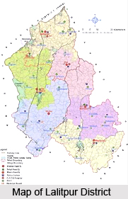
 Lalitpur district is a prominent district of the Indian state of Uttar Pradesh. The district is a part of the Bundelkhand region with the district headquarters in the city of Lalitpur. It is encircled by the Tikamgarh district in the east, Sagar district in the south, and Ashoknagar and Shivpuri districts in the west and the Jhansi district in the north. The town is located between 24 degree 11 minutes and 25 degree 14 minutes north latitude and 78 degrees and 10 minutes and 79 degrees and 0 minutes east longitude.
The district forms a part of the hill country of Bundelkhand. The southern part of the district consists of small hills and through the valleys flow the sparkling rivers over the shelves of granite and quartz. The northern and western part of the district is bounded by the Betwa River and the Jamni River, a tributary of the Betwa forms the eastern part of the district. The southeastern part of the district is bounded by the Dhasan River.
The Lalitpur district was founded in the 17th century by a Bundela Rajput who was a descendant of Rudra Pratap of Orchha.
At that time it was a part of the state of Chanderi. In 1844, during the British rule in India the former state of Chanderi became the Chanderi district. From 1891 to 1974 Lalitpur district was a part of Jhansi district. It became a separate district in 1974. The district is divided into three tehsils Lalitpur, Mehroni and Talbehat. The four prominent towns of the district are Lalitpur, Mehroni, Talbehat and Pali along with seven hundred and fifty four villages. Sprawling over an area of 5,039 sq.km. the district is in the shape of a heart.
The district has a subtropical climate with hot dry summers and cold winters. The economy of the district is predominantly agrarian. Lush green fields and glittering rivers characterize the landscape of the district. The calmness of the district is really enchanting which attracts a lot of tourists. The prime attractions in the district are Deogarh, Ranchourji Neelkantheshwar Trimurti (Pali), Andela, Matatila Dam, Seeronkhurd, Dudhai, Dewa Mata, and BandarGurha.


