Home > Travel > States of India > Barasat
Barasat
Barasat is a city located in North 24 Parganas District of West Bengal. This place is also known for the British establishment and the bamboo fort of Titumir. But now the bamboo fort cannot be traced.

Share this Article:

Barasat, North 24 Parganas, West BengalBarasat is a city in the outskirts of Kolkata. It is located in North 24 Parganas of West Bengal, dotted with many British architecture, Hindu Shiva Temples of Zamindari era and the retail outlets.

Location of Barasat
Barasat is located in West Bengal and is the district headquarters of the district North 24 Parganas.

Connecting with Kolkata
Barasat is a part of the area covered by Kolkata Metropolitan Development Authority. The town is an important railway and roadway junction. Barasat is also the name of a sub-division centring the city.

Administration of Barasat
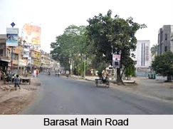
Barasat is established in modern West Bengal as an urban setup in the vicinity of the Kolkata. The town is within the area of Greater Kolkata. There are several significant roads like National Highway 34 (Krishnanagar Road leading towards North Bengal), Jessore Road (road leading to Jessore in Bangladesh via Bongaon); road leading to Basirhat etc. cross through the town.

History of Barasat
It was in the Mughal era, Ram Sundar Mitra had got the Laminar at Barasat town. Sankar Chakrabrorty, a commander of Pratapaditya, The king of Jessore (at present in Bangladesh), came to Barasat in the year 1600, and established himself in Barasat town. In 1700 AD, Hazarat Ekdil Shah, the Muslim saint, started residing at Kazipara in Barasat. He was known as a social reformer. His tomb, located in Kazipara, is a pilgrimage place of Muslim community. Pratapaditya had made his way to Kolkata from Jessore and Siraj- ud- Daullah, the independent Nawab of Bengal had made his way to Kolkata from Murshidabad via Barasat, which are later on converted into two National Highways. After the invasion of British East India Company in India, Barasat became the town of rebels of Shantal origin and as a result the clashes of British and the tribal head Titumir in 1855. After the downfall of Titumir rebellion, Barasat was officially emerged as a textile capital in Kolkata, which is now also followed in modern India.

Geography of Barasat
Barasat is located in the Ganges Brahmaputra delta region in the district of North 24 parganas, West Bengal state in the eastern India. The Bangladesh border at Petrapole is situated about 70 to 80 km from the city. The average altitude is 11 metres. The nearest one is Ganga River, which is flowing about 15 km to the west. The city is in the Gangetic plain lacking any hills.

Visiting Information
Barasat is 22 km from Sealdah Railway Station on the Sealdah-Bangaon branch line. It is at one end of the Barasat-Basirhat-Hasnabad branch line of Eastern Railway. One can easily reach Barasat by bus plying from Sealdah, EM Byepass or one can avail Kolkata Metro by reaching Dum Dum or by train from Sealdah.

Related Articles
West Bengal
Costumes of West Bengal
Culture of West Bengal
Cities of West Bengal
Tourism In West Bengal
North 24 Parganas District
South 24 Parganas District
Tourism in South 24 Parganas District
Culture of North 24 Parganas District


Share this Article:

Related Articles

More Articles in States of India


East Indian States
East Indian States comprises of Bihar, Jharkhand, West Bengal, Odisha and also the Union Territory of Andaman and Nicobar Islands. It defines the cultural heritage, rich historical background and the linguistic unity.
Erode District
Erode District is one of the districts in the state of Tamil Nadu. The district of Erode is having a land-locked area with no sea coast.
Purnia District in Bihar
Purnia District is located in Bihar and extends from River Ganga to Nepal. The district has a rich Hindu history and glorious past.
South Delhi District
South Delhi District is the third largest district of Delhi as far as its area is concerned. South Delhi District is known for its economic, historical, cultural and social significance.
North Indian States
North Indian States formed the cultural and religious unity in spite of having many foreign invasion and the political disturbances from the early era till the British gained supremacy in Indian sub continent.
Kendujhar District
Kendujhar District, spread over an area of 8,240 sq kms, is as varied as the whole of Orissa with waterfalls roaring gorges, mountains and minerals. The manifold expressions of nature in Kendujhar District are considered as unique.
Hooghly district
Hooghly District along the bank of the river Hooghly is one of the principal trading ports of West Bengal.
Districts of South Tamil Nadu
Districts of South Tamil Nadu consist of many tourism destinations like archaeological sites and the history of Pandyas and Cholas. Considering their proximity to the sea, many districts also boast of serene beaches and coastal beauty.
Flora of Arunachal Pradesh
Flora of Arunachal Pradesh includes infinite species and is a subject of great interests for the botanists.
Districts of South Gujarat
Districts of South Gujarat are the epicenter of Jain pilgrimages and the early Hindu kingdoms.
North West States of India
North West States of India consist of three states, which are Rajasthan, Punjab and Haryana. All of them are culturally and traditionally diverse and they have been ruled by different dynasties in historical time.
Geography Of Chittoor District
Geography of Chittoor district is spread along the topography of the land which is divided into two natural divisions; Chittoor has a dry and healthy climate.
Districts of North Rajasthan
District of Northern part of Rajasthan is dotted with ancient forts and medieval villages.
Districts of North Odisha
District of North Odisha has Bengal boundary and shares the same culture. These are reachable if one pays a weekend visit to Digha.
Districts of West Bihar
Districts of West Bihar is comprised of medieval monuments that were built by the different governors of Mughal era.
Districts of South Haryana
Districts of South Haryana consists of many cities of industrial excellence. These districts are dotted with popular tourism destinations.
Medieval History of Assam
Medieval history of Assam narrates the advent and rule of a number of kingdoms in the region. The prominent dynasties of the kingdom left an everlasting imprint on the socio cultural heritage of India.
Geography of Meghalaya
The suitable climate, highland plateaus, rivers and the flora and fauna together forms the geography of Meghalaya.
Districts of Rayalaseema
Districts of Rayalaseema in Andhra Pradesh state has urban population and rural settlements as well.
Districts of South Punjab
Districts of Southern part of Punjab depict medieval history of Punjab and the rise of Sikhs.