 Anuppur district is a tribal dominated district in the state of Madhya Pradesh, which forms a part of the Central India. Anuppur district was created on 15th August in the year 2003 out of Shahdol district and forms a part of the Rewa District division.
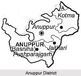
Geography of Anuppur District
Anuppur district consists of a series of mountain ranges and rivers and can be subdivided into three geographical divisions namely, high lands of mountain ranges, low lands of rivers and the Central plateau. The rivers, which flow in the Anuppur district, are Son River, Johila River, Tipan River, Narrmada River, Kewai River and Chandas River. The Maikal Hills are located in this district extends from the southern part of the district to the eastern part
.
The climatic conditions in Anuppur district can be marked as temperate. The monsoon season lasts from June to October. The highest temperature is recorded in the month of June and the lowest is recorded in the first month of the year according to the English calendar. The maximum and minimum temperature of this district remains as 46 degree centigrade and 2.6 degree centigrade respectively.
Nearly, one third of the total area of this district consists of dense forests and regarded as a hilly area. The main trees found in the Anuppur district are Sarai, Teak and Shisham. The flowers of Guli and Mahua grown in this district provide the inhabitants with edible oil. The tribal people of this district also use the flowers of the Mahua tree for making wine.
Demography of Anuppur District
Anuppur is the administrative headquarters of this district. The area of the district measures 3701 square kilometres. Anuppur had population of 749,521 of which male and female were 379,496 and 370,025 respectively. This data was revealed in the year 2011 Population census report. The average literacy rate of Anuppur district in 2011 was 69.08 percent. Gender wise, the male and female literacy rates were 80.05 and 57.89 respectively.
 Economy of Anuppur District
Anuppur district is also very rich in mineral resources and the names of the minerals found in this district are bauxite, coal and fire clay. Most of the coalmines of this district are located in Kotma sub division. The region of Amarkantak is known for its deposits of bauxite. According to the industrial survey of the year 1998, the region is recorded to have an establishment of 106 industries both large scale and small scale. The small-scale industries of polythene and baskets of bamboo are also run in this district. The "bidi" or the local cigarettes factory is also situated in the region of Venkatnagar in the Anuppur district. For the production of electricity, Amarkantak Thermal Power Plant is established. About 94% of the villages of this district are electrified. The total generating capacity of the Chachai Power house is 290 Mega Watts
Economy of Anuppur District
Anuppur district is also very rich in mineral resources and the names of the minerals found in this district are bauxite, coal and fire clay. Most of the coalmines of this district are located in Kotma sub division. The region of Amarkantak is known for its deposits of bauxite. According to the industrial survey of the year 1998, the region is recorded to have an establishment of 106 industries both large scale and small scale. The small-scale industries of polythene and baskets of bamboo are also run in this district. The "bidi" or the local cigarettes factory is also situated in the region of Venkatnagar in the Anuppur district. For the production of electricity, Amarkantak Thermal Power Plant is established. About 94% of the villages of this district are electrified. The total generating capacity of the Chachai Power house is 290 Mega Watts
Anuppur district also has provisions for post and telecommunication facilities. There are 111 post offices in total and their branches are in regular operation in the whole district. There are also six telegram offices and the district is recorded with the provision of 2038 telephone connections. The district also has provisions of public health. There are several community health centres, district hospitals, Ayurvedic dispensaries, and sub-health centres working in this district. The other facilities of Anuppur district include some veterinary hospitals, official insemination centres, police stations and police posts.
The roadway is the main means of transportation as the Metallic Road and the Kachhi Road is at a short distance. The railway facilities are also available for Katni District, Chirimiri and Bilaspur route.


