 Bellary is situated in Karnataka state of India. The district is spread from southwest to northeast and is situated on the eastern side of Karnataka state. The district is 15 degree and 30 minutes and 15 degree and 50 minutes north latitude and 75 degree and 40 minutes and 77 degree 11minutes east longitude.
The geographical area is 8447 sq. km. The district is bounded by Raichur district on the north, Koppal district on the west, Chitradurga and Davanagere districts on the south, and Anantapur and Kurnool districts of Andhra Pradesh on the east. The normal rainfall is 639 mm.
Bellary is situated in Karnataka state of India. The district is spread from southwest to northeast and is situated on the eastern side of Karnataka state. The district is 15 degree and 30 minutes and 15 degree and 50 minutes north latitude and 75 degree and 40 minutes and 77 degree 11minutes east longitude.
The geographical area is 8447 sq. km. The district is bounded by Raichur district on the north, Koppal district on the west, Chitradurga and Davanagere districts on the south, and Anantapur and Kurnool districts of Andhra Pradesh on the east. The normal rainfall is 639 mm.
History of Bellary District
The city takes its name from the word Balari, which refers to goddess Durugamma as this goddess had manifested herself in the town. Another legend is that the city is named after Indra, the king of Gods, who slayed a Rakshasa named Balla who created trouble for the people in Bellary. The word Bellary means `enemy of Balla`.
 Demography of Bellary District
As per 2001 census, the population of the district was 22,45,000. The density of population is 196 per sq. km, which is much lower than the state average of 235 per sq.km. The rural population constitutes 70%. The scheduled caste/scheduled tribe population constitutes 28% of the total population. The sex ratio of the state was 965.
Economy of Bellary District
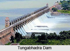
The major occupation of this district is agriculture and 75% total labour force depends on agriculture for their livelihood. The important crops cultivated here are cotton, jowar, groundnut, paddy, sunflower and cereals. The main source of irrigation is Tungabhadra Dam. This district is endowed with rich mineral resources, both metallic and non-metallic minerals. The metallic minerals include iron ore, manganese ore, redoxide, gold, copper and lead. The non-metallic minerals include andalusite, asbestos, corundum, clay, dolomite, limestone, molding sand, quartz, soapstone, granite and red ochre. There is a spectacular growth of industries in Bellary. There are small scale and large-scale industries here.
Visiting Information of Bellary District
Bellary is well connected by road and rail to major cities of Karnataka and neighboring states. Bangalore Airport is the nearest Airport to Bellary. Trains pass through Guntakal, which is one of the important junctions near Bellary. Trains to Delhi, Chennai, and Mumbai and to most of the places in India are available from this junction. Bellary city is well connected by road to all major cities, towns and important cities of neighbouring states. The city is also served by auto-rickshaws and cycle-rickshaws.


