Introduction
 Vidisha is a district of Madhya Pradesh, state of central India. The district derives its name from the head quarter town of Vidisha. Previously it was called Bhilsa, but after 1956, it was called as Besnagar and after that, it was changed to Vidisha. It is one of the famous historical places of Madhya Pradesh.
History of Vidisha District
 History of Vidisha district speaks about the architectural development of the district in the past. Vidisha or Besnagar as it is known in the Pali scriptures, once the prosperous capital of the western dominions of the Sungas, possesses some of the remarkable antiquities which throw light on the appreciable architectural development of the period
.Located in the fork of the Betwa river and Bes rivers, Vidisha district, ten kilometers from Sanchi Stupa occupies a prominent place amongst the ancient Indian districts. In the sixth and fifty centuries BC, it rose to become a major trade centre and a bustling city under the Sunga Dynasty, Satvahanas, Nagas and Guptas. Emperor Ashoka was the governor of Vidisha, and it finds mention in Kalidasa`s immortal Meghdootam. Deserted for three centuries after the sixth century, it was renamed Bhilsa by the Muslims who constructed the now ruined Bija Mandal, a mosque erected from the remains of Hindu temples. Later, it passed on to the Sultans of Malwa, the Scindias and the Mughal dynasty. The Vidisha territory was ruled by the Mauryan Empire, the Sungas, the Nagas, the Vakatakas, the Kanvas, the Guptas, the Parmars, the Kalchuris of Mahishmati, the Chalukya Dynasty, the Mughals, the British, etc.
 The Vidisha district derives its name from the headquarters town of Vidisha. The earliest reference of Vidisha is also there in the great epic of Ramayana by Valmiki. In the epic, it is stated that, the son of Shatrughna called Shatrughati was placed in charge of Vidisha. In Brahmanical religious observance, the place is called Bhadravati, the residence of Yuvanashva who supplied the famous horse to Yudhisthir during his Ashvamedha sacrifice. The historicity of the ancient city of Besnagar, three kilometers from Vidisha and identified with ancient Vidisha, goes back to some centuries before the birth of Jesus Christ. Besnagar figures significantly in Buddhist, Jain and Brahmanical literature in various forms like Vaisyanagar, Vessanagar, etc. Tradition connects the town with Raja Rukmangada who neglecting his own wife for the Apsara Visva named the town Vishvanagar after her. On the destruction of Besnagar, situated on the western side of the Betwa River sometimes after the seventh century A.D., a new town sprang up on the Eastern bank of the River. This new town was known as Bhailaswamin or Bhillaswamin, the name of the place was later corrupted to `Bhilsa` or `Bhelsa`. The name Bhelsa appears to have probably been received on account of the famous Suryamandir dedicated to the Sun god.
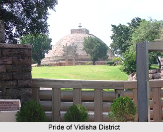
Samrat Ashoka, a prince aged eighteen years, was appointed as a Viceroy by his father, Bindusara, at Ujjain. While on his way from Pataliputra to that place he met Devi, a banker`s daughter of Vidisha or Besnagar of the Sakya clan and married her. Her son Mahendra and daughter Sanghmitra are famous in history as their father`s religious ambassadors to Ceylon. They are known to have carried a twig of the original `Bodhi tree` and led a Buddhist Mission to that country. Devi never visited Pataliputra and stayed at Besnagar only and embraced Buddhism afterwards. A monastery type of building has been excavated near Sanchi setup, about eight kilometers from Vidisha, which is stated to have been constructed for her residence. It is said that before sailing for Ceylon Mahendra came to visit his mother at Besnagar and the mother took her son to a `Chaitya Giri` which, by popular belief was none other than the Sanchi Stupa.
After the Mauryas the Sungas, the Kanvas, the Nagas, the Vakatakas, the Guptas, the Kalchuris of Mahishmati, the Parmars, and the Chalukyas remained in power at Vidisha. Idols regarding these regimes have been found in the Vidisha territory. Some idols and monuments are placed in the District Archaeology office at Vidisha. Later, this region remained under Mughals, Marathas and Peshwas and thereafter became a part of the Schendia`s Gwalior State and was a tehsil of Isagarh Pargana. In the year 1904, it was raised to a district having two tehsils of Vidisha and Basoda till the formation of Madhya Bharat in the year 1948. The District was enlarged in the year 1949 by the merger of small states of Kurwai. The Sironj sub-division, which was formerly in the Kota district of Rajasthan state and small pargana of Piklone belonging to Bhopal were added to the district with the formation of new state of Madhya Pradesh. At the same time, the town and the district were renamed as Vidisha. However, under the Mughals, Aurangzeb tried to rename it as Alamgiri Nagar after himself, but without success. Even today, the antiquity and the modern historical progress of the plateau of Vidisha vividly reflect its grandeur in the form of Besnagar, Gyaraspur, Udaypur, Udaygiri, Badoh-Pathari etc.
Geography of Vidisha District
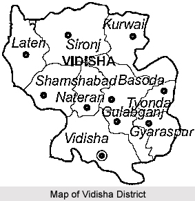 Geography of Vidisha district is vast and it covers a large area in the state of Madhya Pradesh in India. This district is located in between twenty three degree twenty one minutes to the North latitude and seventy seven degree fifteen minutes and seventy eight degree eighteen minutes to the East longitude. The district of Vidisha is situated in the eastern parts of the fertile Malwa Region. The shape of this district in the state of Madhya Pradesh is more or less elliptical and the longer axis lies from North-West to South-East with slight projections on the North, North-West, South and South-West. Its greatest length from North-West to South-East is about 133.6 kilometers and the greatest width from North-East to South-West is about ninety six kilometers. The Tropic of Cancer passes through the Southern stretch of this district which is about two kilometers to the south of the district headquarters. The Vidisha district is bounded in the North by the Guna district in the South by Raisen district and in the East by Sagar district. The total area over which it is spread is about seven thousand three hundred and seventy one square kilometers. The climate of the district of Vidisha is generally dry except during the South-West monsoon season.
The various geological formations occurring in the Vidisha district are Alluvium, Laterite and Deccan Trap with inter-trapped beds. Alluvium occurs over a large part of the area mainly along the course of streams like Betwa, Sagar, Besh, etc. It consists primarily of yellow or grey brown sandy clay and possesses a large proportion of `Kankers`. Along the Betwa River it often forms steep cliffs in the Northern part of the area. Laterite occurs in some places as caps on some high trap hills, but usually as ferruginous cellular rocks capping low lying Deccan trap hills, in places surrounded by alluvium. These are used mainly as a road metal. The Deccan Trap is the most widespread rock formation in this district of the Madhya Pradesh state. These rocks are horizontal or nearly horizontal; the dark lava flows lend to the countryside a terraced appearance. The principal rock is basalt possessing vesicles filled with zeolite, agate, calcite, etc. The inter- trappeans, mainly impure crystalline limestone and cacareous chert occur as a residual blocks and boulders scatters over a surface as well as discontinuous outcrops amidst the Deccan Trap. Small isolated outcrops of intertrappeans mostly lime stone are also present in Vidisha.
The climate here is generally dry. The nights are generally pleasant and justify the praise by the Mughals for a Shab-E-Malwa famous throughout India. The monsoon comes during the month of June and continues till the end of September. The year may be divided into four seasons. The cold season starts from the month of December and ends in February and is followed by the hot summer season till mid-June. The period from mid-June to about the end of September experiences the South-West monsoon. The month of October and November may be termed the post-monsoon or retreating monsoon. The average annual rainfall received by this district 1,229.9 millimeter. During the summer season on individual days the maximum temperature goes above forty six degree Celsius. After the month of October, both the day and night temperatures steadily decreases till January which is the coldest month. The district is affected by cold waves during the cold season in association with the western disturbances passing across the northern part on India and the minimum temperature may drop down occasionally to a degree or so above the freezing point of water and frosts may occur.
Demographics of Vidisha District
In 2011, Vidisha District had population of 1,458,212 of which male and female were 768,799 and 689,413 respectively. The population density of Vidisha district in 2011 is 198 people per sq. km. While on the contrary, in 2001, Vidisha district density was at 165 people per sq. km. Vidisha district administers 7,371 square kilometers of areas. The average literacy rate of Vidisha in 2011 was 72.08. Now in 2011, the total literate in Vidisha District were 884,829. Out of which male and female were 527,959 and 356,870 respectively.
Culture of Vidisha District
Vidisha people mostly use western Hindi (Malvi and Bundelkhandi) and Gondi as spoken language.Shivratri and Ramnavami are the important festivals of Vidisha people. Festivals of Orchha, Malwa, and Panchmarhi are famous among tribals. Bhagoriya festival is the important festival of tribals.Tansen festival , Gwalior Samaroh, Ustad Alauddin Khan festival are the musical festivals every year organized by the Govt. of Madhya Pradesh. It also includes Maihar, Kalidas Samaroh, and Ujjain Samarohas with dance functions.
Education of Vidisha District
There are several schools and Colleges of the district two law colleges such as LBS Law College and SSL Jain Law College and a Civil Engineering Technology Development Cente are also available.
Economy of Vidisha District
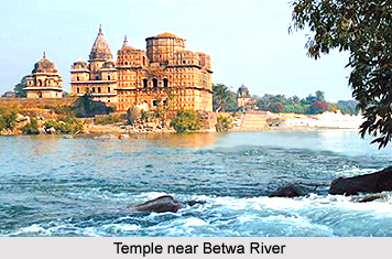
Most of the people of this district are farmers. Betwa River is the main source of irrigation for the production of high quality Wheat, Gram and Soyabin. It is a major tourist place, which also provide livelihood for few section.
Tourism in Vidisha District
 Tourism in Vidisha district provides a lot of options including various temples, caves and other beautiful tourist attractions. The district of Vidisha is very famous for the presence of its old temples and caves which narrate the tale of the rich and glorious past. A railway station by the name of Vidisha is on the Delhi-Chennai, Delhi-Mumbai main line of the Central Railway, at a distance of about fifty six kilometers from Bhopal, the capital state of the state of Madhya Pradesh. Sanchi on the Jhansi-Itarsi section of the Central Railway, and Vidisha, ten kilometers from Sanchi, are more convenient.
Pilgrimage tourism in Vidisha district
The temples in the Vidisha district are the major tourist attractions and people from various parts of the state as well as from different parts of India visit throughout the year. One of the most prominent temples in this district is the Bijamandal or Vijayamandira Temple. The temple was constructed in the eleventh century A.D. and was demolished in A.D. 1682 during the reign of Mughal King Aurangzeb and the mosque was erected on its site using the material of the temple. The mosque was known as Alamgiri Masjid. From an inscription carved on one of the pillars of the original temple it is evident that the temple was sacred to goddess Charchika. This inscription also records the name of King Naravarman. Vijaya was probably another name of this goddess after whom the temple is called Vijayamandira.
 Maladevi temple is quite picturesquely located on the slope of a hill overlooking the valley. Situated on a huge platform cut out of the hillside and strengthened by a massive retaining wall, Maladevi temple is in fact imposing and stupendous building. The Hindola Torana is one of the `Toranas` or ornamental entrance arches leading to a large temple dedicated either to Lord Vishnu or to Lord Trimurti. Hindola means a swing, and this tarana with its two upright pillars and cross-beam has a truly connotative name. All the four sides of the two lofty pillars are carved into panels with insets of the ten incarnations of Lord Vishnu.
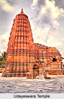
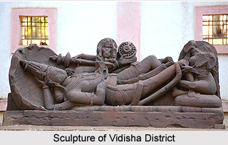
Another famous center of pilgrimage is the Bajramath temple. It is a fine example of a very rare class of temples with three shrines or cells placed abreast. All these shrines are now occupied by Jain idols belonging to the Digambara sect. But it is clear from the sculptures placed on the door frames and niches on the basement that originally these shrines sheltered the Hindu Trinity. The Udayeshwara Temple is situated in Udaipur village of the Basoda tehsil and is also one of the reputed temples in the district. The Gadarmal temple is located in Badoh - Pathari of the Kuwai tehsil of Vidisha district. In medieval times, Badoh was a town of considerable importance as is testified by numerous remains of temples. Gadarmal temple is one of temples, which being of enormous height is visible from a long distance. Dashavtar temple is located to the northern side of the local lake, where exist ruins of a group of small Vaishnava shrines popularly called Sadhavatara temple and a large open pillared hall, both dedicated to one or other of the ten incarnations of Vishnu.
Sola-Kambi temple is situated in the Badoh town of Kurwai tehsil. It is a flat roofed, open and sixteen pillared building locally known as Sola-Khambi. Another temple in the district of Vidisha is the Girdhari temple. This temple is assigned to the eleventh century A.D., known for its fine carvings and sculptures. The temples of Jatashankar and Mahamaya are said to be old and sacred. The former is located at a distance of about three kilometers to the South-West of Sironj in forest area. It is said that Tatya Tope of the 1857-fame has halted here for some time. The Mahamaya temple is situated five kilometers to the South-West of Sironj. This temple is placed on a hill and an annual fair is also held at this place which attracts people in large numbers.
 Another major attraction is the idol of Chandranath. It is the oldest known monument, the eighth Jain Tirthankar found at Dharampur near Sironj. The inscription on this huge image is dated in Vikrama Samvat Era 1112, corresponding to A. D. 155.
Leisure tourism in Vidisha district
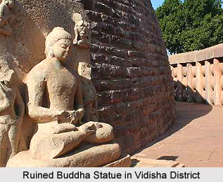
Udaigiri Caves are famous places of tourist interest in the district of Vidisha. Cut into the sandstone hill, six kilometers from Vidisha and three kilometers from Sanchi are a group of rock-cut cave sanctuaries. This site of archaeological importance is between the Beas River and the Betwa River. The site is known for its ancient rock-cut temples excavated in an isolated sandstone hill and the numerous Buddhist remains in its neighbourhood. This isolated hill extends from North-West to South-East and is about one kilometer long, rising to a height of about one hundred and then meters above the plain. Traces of some ancient buildings were also found here. These temples are known as Udaigiri. Some of these contain inscriptions, dated and undated, of great importance. The caves are of generally small chambers, enshrining idols or images of various dynasties carved into the rock of the hill. The caves and the other remains found at the site show that the site has passed through the influence of Jainism, Buddhism and Hinduism in those days.
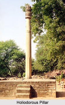
Holiodorous Pillar is one of the foremost tourist attractions in the district of Vidisha in the state of Madhya Pradesh in India. As per the Puranas, `Bhagabhadra` was a King of Sunga dynasty. During his reign, the Greek King Antialcidas of Taxila sent Dion`s son Heliodorous, as his personal Ambassador to the Sunga court at Vidisha and a part of this information is inscribed on a lofty Garuda Pillar (Eagle Mounted Tower) locally named as Kham-Baba a favourite deity of Bhois or Dhimars. The inscription engraved on the pillar records the name of the pillar as Garuda-dhvaja, the column surmounted by Garuda which was erected by Heliodorous honouring God Vasudeva in front of the temple of Vasudeva.
Shalbhanjika is another attraction in this district. It is a rare sculpture which has been found at Gyaraspur. It is an exquisite stone figure of a Vrishaka (wood nymph) which belonged to a period between the eighth and the ninth century A.D. and kept in the archaeological museum, Gwalior. It has been brought there from Gyaraspur. This matchless oriental beauty represents a Shalbhanjika. The sculptured figure stands in a tribhanga posture formed by bending her beautiful body in triple torsion and triple flexion while her face is alive with an intense expression. Sironj town is the headquarters of a tehsil of the same name and is located to the North-West of Vidisha, with which it is connected by roads on which buses ply regularly. The place is well-known for the Calicos and Muslin.


