Introduction
Bhojpur District is one of the administrative districts of Bihar and it has its headquarters at Arrah town. It is the principal town in Bhojpur District. Bhojpur District occupies a total of 2474 sq kms. It is situated at height of 192.989 meters from the sea level. Bhojpur District is located at longitude of 83 degree 45 minutes to 84 degree 45 minutes east and the latitude is 25 degree 10 minutes to 25 degree 40 minutes north. Bhojpur District is bounded by Chhapara and Ballia Districts of Uttar Pradesh in the north, by Rohtas District in the south, by Patna, Jahanabad District and Uarwal District in the east and by Buxar District in the west.
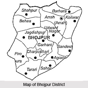
Bhojpur district has three sub-divisions namely Arrah Sadar, Jagdishpur and Piro and 14 development blocks. There are 1244 villages in the district. Administrative set-up of Bhojpur District includes 228 Panchayats and 12 revenue circles, 22 Police Stations, 5 Sub-Police Stations, 1 Railway Police Station, 7 Out-Post-Police Stations. Administration of Bhojpur District is headed by Deputy Commissioner with the aid of assistant officers.
History of Bhojpur District
Bhojpur District came into existence in the year 1992. Earlier this district was part of old Shahabad District. In 1972 Shahabad District was divided in two parts namely Bhojpur and Rohtas. Buxar was a subdivision of old Bhojpur District. In 1992, Buxar became a separate district.
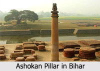
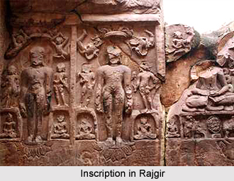
Historical evidences show that Bhojpur district has a close linkage with its parent district of Shahabad, which had an old and interesting history. History of Bhojpur District suggests that Arrah, the headquarters of the district derives its name from the Sanskrit word `Aranya`, which means forest. In the old days, Shahabad formed part of the ancient kingdom of Magadha which also included portions of Patna and Gaya district. Though included in the kingdom of Emperor Ashoka, absence of Buddhist monuments from a greater part of the district suggests that it remained almost immune from the Buddhist influence of the time.
Not much is known about the history of Bhojpur District after the fall of Gupta Empire. In all probability it declined and came under control of petty chieftains of aboriginal tribes. The most dominant people during this period were Chero tribes. They ruled over the greater portion of the district, which was followed by the Rajputs from Ujjain in the province of Malwa Plateau. Raja Bhoj of Bhojas was their king and the term `Bhojpur` was derived from his name.
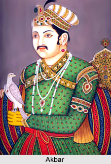
Medieval period history of Bhojpur District describes that Babur proclaimed his sovereignty over Bihar in 1529 after his victory over the Afghan rulers. In commemoration of this event, the place was called Shahabad, which literally means `the city of Emperor`. Akbar, after his accession, included the district of Shahabad in his empire. However, the Rajas of Jagdishpur and Bhojpur defied the Mughals. The Raja of Bhojpur rebelled against Jahangir. After these events, the district had a very uneventful history till 1857 when Kunwar Singh revolted against the British rulers. In this way, the history of 1857, especially of Jagdishpur and Arrah of Bhojpur district is glorious.
Further, it is also stated that the history of `Quit India Movement` in 1942 is also written by the blood of the virtuous revolutionaries of Bhojpur District. As per the historical records, Shahabad District had also witnessed many protest movements against the British rulers.
Geography of Bhojpur District
Geography of Bhojpur District consists of extremely fertile areas. In fact, this region is considered to be one of the best wheat-growing areas in Bihar. The district has rivers running through its three sides. Ganga River forms the northern boundary of the district. The low-lying rich alluvial plains in the north-eastern and owe their fertility to the river Ganges. The rivers Chher River and Banas River fall into the Ganges. Son River is another important river in the district. Son runs along the southern and eastern boundaries of Bhojpur District.
Bhojpur district is situated at a height of 193 metres above sea level. April and May are known as to be the hottest months in this area. Monsoons arrive here within June`s third week and the rains continue till September. November marks the beginning of the winter season and the coldest month is believed to be the coldest month in Bhojpur. The temperature drops to a minimum of 10 C.
The climate of the district is of moderately extreme type. The hot weather season begins about the middle of March, when hot westerly winds begin to blow during the day. The months of April and May are extremely hot. Monsoon sets in by the third week of June and continues till about the end of September or the early part of October. The cold weather season begins from November and lasts till the beginning of March.
The climatic condition is marked by hot westerly winds that blow in the month of March and chilly winters commences from November and continues till March. The total area of Bhojpur measures about 2,395 square kilometres and this area experiences extremes of climate. The district of Bhojpur is placed between the longitude of 83 degree¸ 45` to 84 degree¸ 45` East and latitude of 25 degree¸ 10` to 25 degree¸ 40` North.
Thunderstorms occur during the initial days of the arrival of the monsoons. The monsoons are very humid and July and August are quite wet as this area receives the maximum quantity of rainfall in June. The average amount of rainfall is about 300 metres. Easterly winds continue blowing during the months of June till September and is often accompanied by rainfall in October. During May, westerly winds keep blowing.
Mines and minerals resources in new Bhojpur District are very little. The only mineral product in this district is the sand from Son River. In this district both the irrigated and un-irrigated areas except the small hills are being exploited for cultivation.
Demography of Bhojpur District
According to the Population Census in the year 2011, Bhojpur District had population of 2,720,155. Out of which the male and female were 1,431,722 and 1,288,433 respectively. The population of Bhojpur District constituted 2.62 percent of total population of Bhojpur District. The population census of 2011 shows the population density of Bhojpur district is 1,136 people per sq. km. Bhojpur district administers 2,395 square kilometers of areas. The average literacy rate of Bhojpur in 2011 was 72.79 percent compared to 58.96 of 2001. If things are looked out at gender wise, male and female literacy were 84.08 and 60.20 respectively. For 2001 census, same figures stood at 74.29 and 41.80 in Bhojpur District. The total literate in Bhojpur District were 1,659,049 of which male and female were 1,010,138 and 648,911 respectively.
Tourism in Bhojpur District
Tourism in Bhojpur district consists of innumerable religious as well as historical places which attract thousands of visitors every year. The Sun Temple at Dev, Aranya Devi Temple, Chaturvuj Narayan Mandir, Paihari Jee Ka Ashram, Sahi Jama Masjid and Jagdishwar Shiv Temple are some of the well-known tourism destinations of this district.
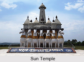
Sun Temple
This temple, which is situated at Dev possesses the statue of the Sun God, which belongs to the 14th century. The Sun Temple is present in the Dev village in Tarai block.
Gundi Village
This village is famous as it is the birthplace of the saint named Awadhoot Bhagwan Ram, who is also referred to as Bhagwan Ramji or Sarkar Baba. This saint is believed to have been born in the year 1937. It is said that he later shifted to Baba Keenaram Sthal when he was only seven years of age.
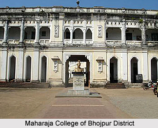
Maharaja College
This educational institution is considered to be a significant historical site since a tunnel which was joint with Kunwar Singh`s fort at its entry point is located in the premises of this very college. It is present in Ara.
Parswanath Mandir
Parswanath Mandir is a very ancient Jain temple which is located at the village of Masadh.
Mahamaya Mandir
The Ekwari village, which is present in the Sahar block is an important place which draws numerous devotees and is said to have been constructed during the age of the Mughals.
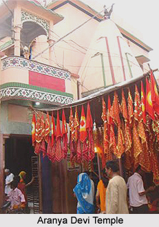
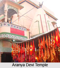
Aranya Devi Temple
Aranya Devi Temple houses its presiding deity, who is the Forest Goddess and is respected as the local goddess of the town of Ara. There are two statues here. One is that of the `Adi Shakti` and the other one had been established by the Pandavas.
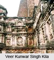
Veer Kunwar Singh Kila
This fort is located in Jamshedpur and belonged to a famous warrior which belonged to the area of Jagdishpur.
Venkatesh Mandir
Venkatesh Mandir is present in the Perhap village and shelters a statue.
Maa Kali Mandir
Located at Bakhorapur, Maa Kali Mandir is about 15 km from Ara, on the river bank of Ganga and is amongst the oldest temples in the country. This temple boasts of a very high statue of Goddess Kali which measures about 85 feet. Shootings of different films are conducted near the premises of this temple.
Bhavani Mandir
Also known as the `Chaturvuj Baraon`, Bhavani Mandir contains a giant statue which belongs to the 13th century. The architecture of this temple is amazing.
Mahathin Mai Mandir
Situated at Bihiya, Marathin Mai Mandir is present in Bihiya and attracts several lady devotees.
Chaturvuj Narayan Mandir
This temple is present in Chaturvuj village and consists of a very old statue of Laxmi Narayan.
Baba Yagyeshwar Dham
Baba Yagyeshwar Dham is actually a temple dedicated to Lord Shiva and is situated in Jagdishpur. This temple is believed to be constructed by Lord Krishna. Legends state that Maharshi Yagyavalka had supervised the creation of this temple.
Jagdishwar Shiv Mandir
This temple is situated in MILKI (Khutahan) and has been made by Late Jagdish Giri, on the model of Birla Temple. It is a Param Pita Parmatma Shiv Temple.
Paihari Jee Ka Ashram
This ashram is situated at the village of Dhrampur at Sahar block.
Gadh Kali Mandir
Gadh Kali Mandir is present in Garhani Taluk, at a distance of approximately 20 km from Ara Railway station. This temple is quite ancient and has been rebuilt in the year 2009 to 2010.
Sree Hanuman Mandir
Sree Hanuman Mandir is located at a distance of nearly 9 km from Ara Railway Station, in Matiyara, Kayamnagar.
Sahi Jama Masjid
Sher Shah is believed to have constructed the Sahi Jama Masjid which is situated at Garhani Bazzar. At present, this mosque is undergoing renovation.
Lakar Sah ki Mazar
Lakar Sah ki Mazar is a renowned shrine of a regional Muslim saint and is present in Sahpur.
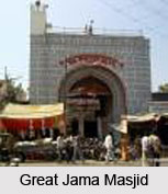
Great Jama Masjid
The Great Jama Masjid is present at Bhaluana village and recently, some renovations are in progress in order to impart an aesthetic outlook to this Masjid.
Bhojpur district also includes numerable other tourist spots, many of which are historical, like Krishan Garh, Maa Kali Temple, Baba Dineshwar Nath Dham and others. The Jain Sidhant Bhawan is a reputed library in this district which possesses a praiseworthy collection of materials which belong to the religion of Jainism.
Bhojpur District has different types of small and cottage industries other than the agro-based industries.