 Churachandpur District is the largest administrative district of Manipur with its headquarters located at Churachandpur. It is also said that among the hill districts, the fastest growing district headquarters and hill-town is that of Churachandpur. It is truly an island of peace, tranquility, prosperity and progress. Several tribal groups reside in this area. Churachandpur District, in the southwestern corner of Manipur, has an area of 4570 sq km. Its location is 23 degree 55 minutes to 24 degree 30 minutes north and 92 degree 59 minutes to 93 degree 50 minutes east. It is a hilly district with a very small percentage of the area being plain.
Geography of Churachandpur District
Geography of Churachandpur District includes no primary forest and the secondary forest including mixed bamboo forest, covers an area of about 118092 hectares. The area under wasteland is 98,424 hectares and the total area of the water bodies is 2,144 hectares. The beauty of the landscape of Churachandpur District is supplemented by the climate which is temperate and salubrious. The maximum temperature recorded in the district is 37 degree Celsius while the minimum temperature recorded is 10 degree Celsius. The highest rainfall is 3080 mm and the lowest is 597 mm. Maximum humidity is 100 per cent and the minimum 61 per cent. The winter extending from November to February is cold, particularly in the hills but days are bright and sunny. The monsoon months stretch from May-June to September with heavy showers almost throughout the period. The spring and summer months are mildly pleasant despite high humidity.
Demography of Churachandpur District
According to the provisional data of 2001 census, the total population of Churachandpur District is 2, 23,866. Literacy rate in the district is quite high, the percentage being 64.38 (72.6 per cent is male literacy rate and 56.4 per cent is female literacy rate). Unlike most parts of the state and the country, the sex ratio is in favour of the female gender: 1034 per 1000 male. Churachandpur District is mainly inhabited by several tribes, mainly belonging to the Kuki-Chin-Mizo group. Each tribe has a distinct social order as well as community laws. The system of hereditary chieftainship as well as community ownership of village land is prevalent in the district. All tribal societies are patriarchal. Women also play a significant role in agriculture and animal husbandry, besides being actively involved in weaving.
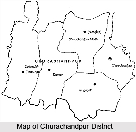
Administration of Churachandpur District
Churachandpur District is divided into 5 Revenue Sub-divisions, namely Churachandpur, Singngat, Thanlon, Parbung (Tipaimukh) and Henglep. Further, the administrative set-up of this district includes six Tribal Development Blocks. The Revenue sub-Divisions are adjoining with the Tribal Development Blocks except for Churachandpur Sub-Division where there are two Blocks namely Churachandpur and Samulamlan. The Sub-Divisional Officer also functions as the Block Development Officer.
Education is spreading rapidly through several English medium schools in Churachandpur District. In the past several years the society has undergone radical change.


