Geography of Golaghat District
Geography of Golaghat District includes vast tropical forests and plain lands. The topography of the district is also marked by swampy vegetation.

Share this Article:

Geography of Golaghat DistrictGeography of Golaghat District mainly includes huge area and a pleasant sub-tropical climate reflecting the scenic beauty of the region. The total area of this district is near about 3502 sq kms and it lies 100 meter above the mean sea level. Golaghat District is surrounded in the north by Brahmaputra River; in the south by Nagaland; in the east by Jorhat and in the west by Karbi Anglong and Nagaon districts. It is strategically positioned between 26 degrees to 27.1 degrees latitudes and 93 degrees to 94.18 degrees longitudes.

Geography of Golaghat District also comprises several rivers that are flowing through the region. Dhansiri is the chief river of this district, which originates from `Laisang peak` of Nagaland. It flows through a distance of 352 km from south to north before joining Brahmaputra River. Its catchments area is 1220 sq kms. Doyang, Nambor, Doigrung and Kalioni are the main four streams of Dhansiri River. Doyang joins with Dhansiri River at the south point of Golaghat town. The other rivulets of this main river of the region originate from Karbi-Anglong and flow in the west to east direction. The river Kakodonga marks the border of Golaghat and Jorhat districts. It also originates in Nagaland and flows in the south-north direction.

The climate of Golaghat District is tropical with a hot and humid weather existing in most of the summer and monsoon months. The average annual rainfall of this region is 1300 mm. Maximum rainfall occurs in the months of June and July. The maximum temperature of the district is 38 degree Celsius in June and minimum temperature is 10 degree Celsius in the month of December. Wind direction is from northwest to southeast. Further, the vast geography of Golaghat District also includes tropical evergreen and semi evergreen forest; tropical grassland in Kaziranga National Park and swampy vegetation.

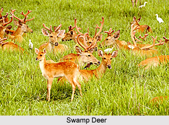
The flora and fauna of Golaghat District are rich and diverse. Nambor Reserve Forest is very rich in plant diversity. Rare and endangered plant species are found in this forest. Further, the fauna of this region is rare and varied too. Besides the one horned Rhino, Swamp Deer, Water Buffalo and Indian Elephant of Kaziranga National Park, Golaghat District harbours various other endangered wildlife such as Turtle and Tortoise, Butterflies, Honeybee, Great Indian Hornbill, Bengal Florican, White wing Wood Duck, Hoolak Gibbon, Pigtail Macaque, Slow loris, Chinese Pangolin, and much more. Thus, it can be said that the geography of Golaghat District is subjugated by huge range of tropical forests comprising endangered species.


Share this Article:

Related Articles

More Articles in States of India


East Indian States
East Indian States comprises of Bihar, Jharkhand, West Bengal, Odisha and also the Union Territory of Andaman and Nicobar Islands. It defines the cultural heritage, rich historical background and the linguistic unity.
Erode District
Erode District is one of the districts in the state of Tamil Nadu. The district of Erode is having a land-locked area with no sea coast.
Purnia District in Bihar
Purnia District is located in Bihar and extends from River Ganga to Nepal. The district has a rich Hindu history and glorious past.
South Delhi District
South Delhi District is the third largest district of Delhi as far as its area is concerned. South Delhi District is known for its economic, historical, cultural and social significance.
North Indian States
North Indian States formed the cultural and religious unity in spite of having many foreign invasion and the political disturbances from the early era till the British gained supremacy in Indian sub continent.
Kendujhar District
Kendujhar District, spread over an area of 8,240 sq kms, is as varied as the whole of Orissa with waterfalls roaring gorges, mountains and minerals. The manifold expressions of nature in Kendujhar District are considered as unique.
Hooghly district
Hooghly District along the bank of the river Hooghly is one of the principal trading ports of West Bengal.
Districts of South Tamil Nadu
Districts of South Tamil Nadu consist of many tourism destinations like archaeological sites and the history of Pandyas and Cholas. Considering their proximity to the sea, many districts also boast of serene beaches and coastal beauty.
Flora of Arunachal Pradesh
Flora of Arunachal Pradesh includes infinite species and is a subject of great interests for the botanists.
Districts of South Gujarat
Districts of South Gujarat are the epicenter of Jain pilgrimages and the early Hindu kingdoms.
North West States of India
North West States of India consist of three states, which are Rajasthan, Punjab and Haryana. All of them are culturally and traditionally diverse and they have been ruled by different dynasties in historical time.
Geography Of Chittoor District
Geography of Chittoor district is spread along the topography of the land which is divided into two natural divisions; Chittoor has a dry and healthy climate.
Districts of North Rajasthan
District of Northern part of Rajasthan is dotted with ancient forts and medieval villages.
Districts of North Odisha
District of North Odisha has Bengal boundary and shares the same culture. These are reachable if one pays a weekend visit to Digha.
Districts of West Bihar
Districts of West Bihar is comprised of medieval monuments that were built by the different governors of Mughal era.
Districts of South Haryana
Districts of South Haryana consists of many cities of industrial excellence. These districts are dotted with popular tourism destinations.
Medieval History of Assam
Medieval history of Assam narrates the advent and rule of a number of kingdoms in the region. The prominent dynasties of the kingdom left an everlasting imprint on the socio cultural heritage of India.
Geography of Meghalaya
The suitable climate, highland plateaus, rivers and the flora and fauna together forms the geography of Meghalaya.
Districts of Rayalaseema
Districts of Rayalaseema in Andhra Pradesh state has urban population and rural settlements as well.
Districts of South Punjab
Districts of Southern part of Punjab depict medieval history of Punjab and the rise of Sikhs.