Home > Travel > States of India > Batasia Loop
Batasia Loop
Batasia Loop in Darjeeling, a tourist attraction, was build to lower the slope of Darjeeling Himalayan Railway.

Share this Article:

Batasia Loop, Darjeeling District, West Bengal
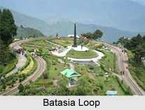
Batasia Loop is a popular tourist attraction site nestled in the Darjeeling District of West Bengal. It is a loop or switchback. It was created to lower the gradient of ascent of the Darjeeling Himalayan Railway in Darjeeling district. At this place, the tracks meander around over itself through a tunnel and overlook a hilltop. The railway line negotiates a circle and ascends 1,000 ft in altitude. Batasia Loop was commissioned in 1919.

Location of Batasia Loop
It is located around five km from Darjeeling, below Ghum which is the highest railway station. It is situated on Hill Cart Road that is National Highway 55 that goes all the way to Siliguri.

Attractions of Batasia Loop
Batasia Loop is a beautiful place and there are lots of places of interest in the vicinity that are worth visiting. Batasia means airy space. The area is covered with grass and is adorned with beautiful seasonal and perennial flowers and shrubs. From the Batasia Loop, the tourists can enjoy a panoramic view of Darjeeling town with the Kanchenjunga and other snow capped mountains in the backdrop. The picturesque beauty of this place is best enjoyed by toy train rides. From Darjeeling station joy rides in the toy train can be availed of to Batasia Loop and back.

Batasia Loop is also a memorial to the Gorkha soldiers who gave their lives after the Indian Independence in 1947. This spot is also the photographer`s paradise. The War Memorial, constructed in memory of the brave sons of Darjeeling who died for the country since Independence in 1947, is worth visiting tourist attraction near Batasia Loop.

This article is a stub. You can enrich by adding more information to it. Send your Write Up to [email protected]


Share this Article:

Related Articles

More Articles in States of India


East Indian States
East Indian States comprises of Bihar, Jharkhand, West Bengal, Odisha and also the Union Territory of Andaman and Nicobar Islands. It defines the cultural heritage, rich historical background and the linguistic unity.
Erode District
Erode District is one of the districts in the state of Tamil Nadu. The district of Erode is having a land-locked area with no sea coast.
Purnia District in Bihar
Purnia District is located in Bihar and extends from River Ganga to Nepal. The district has a rich Hindu history and glorious past.
South Delhi District
South Delhi District is the third largest district of Delhi as far as its area is concerned. South Delhi District is known for its economic, historical, cultural and social significance.
North Indian States
North Indian States formed the cultural and religious unity in spite of having many foreign invasion and the political disturbances from the early era till the British gained supremacy in Indian sub continent.
Kendujhar District
Kendujhar District, spread over an area of 8,240 sq kms, is as varied as the whole of Orissa with waterfalls roaring gorges, mountains and minerals. The manifold expressions of nature in Kendujhar District are considered as unique.
Hooghly district
Hooghly District along the bank of the river Hooghly is one of the principal trading ports of West Bengal.
Districts of South Tamil Nadu
Districts of South Tamil Nadu consist of many tourism destinations like archaeological sites and the history of Pandyas and Cholas. Considering their proximity to the sea, many districts also boast of serene beaches and coastal beauty.
Flora of Arunachal Pradesh
Flora of Arunachal Pradesh includes infinite species and is a subject of great interests for the botanists.
Districts of South Gujarat
Districts of South Gujarat are the epicenter of Jain pilgrimages and the early Hindu kingdoms.
North West States of India
North West States of India consist of three states, which are Rajasthan, Punjab and Haryana. All of them are culturally and traditionally diverse and they have been ruled by different dynasties in historical time.
Geography Of Chittoor District
Geography of Chittoor district is spread along the topography of the land which is divided into two natural divisions; Chittoor has a dry and healthy climate.
Districts of North Rajasthan
District of Northern part of Rajasthan is dotted with ancient forts and medieval villages.
Districts of North Odisha
District of North Odisha has Bengal boundary and shares the same culture. These are reachable if one pays a weekend visit to Digha.
Districts of West Bihar
Districts of West Bihar is comprised of medieval monuments that were built by the different governors of Mughal era.
Districts of South Haryana
Districts of South Haryana consists of many cities of industrial excellence. These districts are dotted with popular tourism destinations.
Medieval History of Assam
Medieval history of Assam narrates the advent and rule of a number of kingdoms in the region. The prominent dynasties of the kingdom left an everlasting imprint on the socio cultural heritage of India.
Geography of Meghalaya
The suitable climate, highland plateaus, rivers and the flora and fauna together forms the geography of Meghalaya.
Districts of Rayalaseema
Districts of Rayalaseema in Andhra Pradesh state has urban population and rural settlements as well.
Districts of South Punjab
Districts of Southern part of Punjab depict medieval history of Punjab and the rise of Sikhs.