Introduction
 Rayagada District is one the administrative districts of Odisha. Rayagada town is the district headquarters. This district is known for its longest history. Rayagada District came functionally into existence on 2nd of October in the year 1992 as part of the extension plan of districts in the state. But as the historical document goes, the region of Rayagada existed far back in the ancient time and leaving the copper plates, rock inscriptions and the coins there is no authentic written document of Rayagada District.
History of Rayagada District
However it is evident from the coins and the inscriptions excavated, that Rayagada was the centre of attraction in all ages. In the 3rd century B.C, the, entire region of Rayagada was included in the Kalinga empire and Ashoka was at the helm of administration. From the rock edicts of Ashoka the history of Rayagada during the Ashokan regime is interpreted. Bhojpur Rock inscription in Brahmi of Rastrik King Mandhata adds some facts about the historical records of the Rayagada district. Kharvela, the only Aryan King ever ruled in Odisha defeated the Rastriks. Kharvela was ousted by the military campaign of Samudragupta. The Allahabad Prasasti Inscription, framed by Harishena provides evidence to the socio-economic and cultural life of Rayagada during the reign of Samudragupta. During Ganga Vansi and Surya Vansi Kings, Rayagada was under Dadarnab Dev of Gudari Kataka. A rock inscription found at Pataleswar temple in Brahmi script depicts the era of the Ganga and the Surya kings in Rayagada. In the subsequent periods, many indigenous and foreign rulers colonised the region of Rayagada till the British arrived as the political head of India including Odisha. However during the British supremacy Rayagada was a significant part of Jeypore Zamindari that later transformed into the princely state of the British rulers. Till independence Rayagada, survived as the subdivision of Jeypore Zamindari.
Geography of Rayagada District
Strategically, it lies approximately at 19.17° N 83.42° E. It has an average height of 207 meters or 679 feet. From Berhampur city of Orissa, it lies on the way to Koraput . Demographic updates helps one to locate the details of the geography of Rayagada. In this regard a special mentioning may be made of the Census report. It was issued forth in the year 2001 and throws light on certain demographic details like literacy rate, population status etc. Thus according to this report, Rayagada has shown a population count of 57,732. Out of it, male population constitutes 51 % .In comparison; female populace is less and thus constitutes 49 %. Children who are below six years of years constitute 12 % of the total population. Also the literacy rate of Rayagada is quite high even than that of the entire nation. In other words, 64 % and 59.5 % are the average literacy rates of Rayagada and India respectively.
Administration of Rayagada District
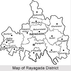
 Administration of Rayagada District includes two sub divisions namely Rayagada and Gunupur. There are 11 development blocks and these are Rayagada, Kashipur, Kolonara, Kalyansinghpur, Gunupur, Gudari, Padmapur, Ramanaguda, Bissam Cuttack, Muniguda and Chandrapur. The administrative set-up of Rayagada District comprises four tehsils namely Rayagada, Kashipur, Gunupur and Bissam Cuttack. It also includes one Municipality that is Rayagada.
Demography of Rayagada District
Rayagada District has a total population of 832019, out of which tribal population is 473379. In other words, the district is predominantly a tribal populated district with 57.52 percent of tribal population. Literacy rate of the district is 35.61 percent, with 47.35 percent male literacy rate and 24.31 percent female literacy rate.
Culture of Rayagada District
 The culture of Rayagada is enriched by its plethora of dance forms, music, life style of tribes. Despite the in flow of modern civilization and technical progress Rayagada people still has its maintained its originality, customs and tradition Fairs and festivals are part and parcel of culture of Rayagada which further enhances its prosperity and majesty.
Cuisine
Cuisine is a key ingredient of knowing the culture of Rayagada in a true sense. In fact the people have developed taste for spicy and tasty food. Dishes are simple yet quite sumptuous. People of other places like the dishes that they prepare also as well. Food also forms an integral part of their festive celebration. Both vegetarian and non- vegetarian dishes are popular. Staple food is rice. Their meals comprise of a chief course and also dessert. Pickles, curd is also taken with main course. Sweet dishes are equally popular. Majority of the sweet dishes of the entire state are prepared from milk. Kheer and rice pudding are some of the sweet delicacies.
Veggies love to savor delicacies like Alu matter Alu bhajia, alu dum, and charchari. Amongst the non - vegetarian delicacies like fish and other seafoods are widely popular. Due to the proximity of Orissa to seacoasts, the prawns, crabs and fishes are profusely cooked in large quantity. Fish curry, prawn malay curry, crab kalia and chilly fish are popular sea foods in the state. Mode of preparing food also is quite unique. They cook dishes like chicken curry, mutton curry, chicken masala and chilly chicken using less oil Food also is of fewer calories.
Fairs and festivals also are an integral part of the culture of Rayagada. Varied festivals of are feted which are related to different themes like religion, tribal community, music festivals, and a lot of seasonal fairs and exhibitions are organized. Major festival is Rath Yatra, which was held during the months of June-July. Other festivals include Chaitra Parba of Maa Maji Ghariani Goddess; Ganesh Puja. Kali Puja is celebrated in the month of November . In the following another festival , namely Lakshmi Puja is A month before Kali Puja , i.e on the month of October Dasehera is feted in great enthusiasm. Annual celebration of Every year Gram Devata is celebrated during the months of March- April . It went continuously for nine days. Christmas also is a popular festival of Rayagada.
Durga Puja typifies the practice of good over evil. The festival is devoted to the deity Goddess Durga who is an epitome of power. It is a 5-day festival. At the time of festival tourists throng the streets, while number of devotees gather near `Puja mandaps ` to offer their prayers .On Vijayadashami, the last day of the Durga Puja festival, huge procession was organized for bringing out the images of Goddess Durga images into the streets. Ultimately these images are emerged into the water bodies.
Konark Festival is celebrated during December 1 to 5. To participate into this festival people from Rayagada visit the Konark temple. Various dance and melodious songs energize the whole of the festive mood.
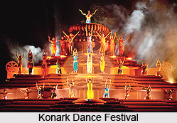 The Konark Dance Festival also is organized at the same time. Thus a whole ambience creates a special charm amongst those who are present. Another popular festival of Konark is Megha Mela, which used to be held during the January - February. It falls on 7th day of Magha month. It also is widely visited by people of Rayagada and also that of other countries.
Held at the time period between March and April, Taratarini Mela is one of the largest melas or fairs of the entire state. During the month of Chaitra , on every Tuesday , this gala fair Chaitra` month starts from middle of March to middle of April. Venue is the Taratarini Pitha , which is located almost thirty kms from Berhampur city of Orissa . At the time of the festivals, a myriad of tourists gather there to cherish the festive mood of the place. Naturally people of Rayagada also pay visit to this place as well.
Puri Beach Festival is feted during November 5 to 9. It is the time when people go gaga with festivity. People of Rayagada also participate into it in great jubilance. This magnificent festival is conducted by the Hotel and Restaurant Association of Orissa (HRAO). The Ministry of Tourism, Government of India, the Department of Tourism, Government of Orissa, Development Commissioner of Handicrafts and the Eastern Zonal Cultural Center, Calcutta act as co-sponsor. Various events like fashion shows and other cultural programs are organized at the exotic sea beaches of Puri.
Mood of joy is created with the celebration of Dhanu Yatra. It is held during December-January. It is organized commemorating the auspicious visit of Lord Krishna to Mathura.
Dhanu Yatra celebration are related to the Lord Krishna`s visit to Mathura. The charming "Bow" ceremony is held at Bargarh. Bargarh town becomes Mathura, Jira river becomes Yamuna . Also Amapalli village lying on river bank becomes Gopa. Naturally, people of Rayagada also go there and enjoy the festival to their hearts content.
Dance and Music
The lives of people of Rayagada get fiesta with dance and musical bonanza. In fact the state of Orissa has its treasure of music. The images of figures of dancers or musicians that were engraved on primitive temples of the state bear proof of this rich tradition. Evidences of saint poets composing and singing lyrical poems are not rare. There were bards who roam about and hymning songs, which act as means of propagating religious ideas.
Music of Orissa is mainly classical which incorporate several elements that are common to other musical genre like Hindustani and Karnatic. Ragas and talas are such musical elements.
Dance forms also have enriched the tradition and culture of Rayagada. One of the popular forms of dance is Odissi Dance. This classical dance form originates in the temple premises. Elements like its rhythm, bhangis and mudras used in Odissi are unique and distinctive. The theme of Odissi dance centers on love of Lord Krishna and his consort Radha. It is a lyrical form of dance and is also subtle.
 Chhau Dance is a primeval dance form. It has its origin in the mock fights of the Oriya paikas or warriors who used to fight following the rhythms in accompaniment of musical instruments of the natives. This stylized form of dance follow the basic principles of scholarly the Abhinaya Darpana of Nandikeswara and also Bharat Muni`s Natya Shastra.
Mahari Dance is an exquisite dance format, which follows the tradition of Sri Mandira. It is an epitome of the tradition history of art of Utkal. It commemorates the holy union of Lord Jagannath and great Nari Mahari.
Apart from these a handful of folk dancing forms also have gained popularity. The Jatra. Pala and Daskarhia representing significant facets of the culture of folk people of Orissa Jatra is a type of desi theatre. Theatrical elements like song, dance, performance, playing and theatrical clash are being incorporated in it.
Tourism in Rayagada District
 Rayagada, a land of meadows, forests, waterfalls and terraced valleys, peopled by colorful tribals and many Primitive Tribal Groups is an important tourist destination in Orissa. The appeal of the Rayagada district at the lap of nature is alluring to the tourist nationwide. The tourism industry has grown up in Rayagada centering various charms scattered throughout the district and it also serves as the base for visiting the near by place of interest.
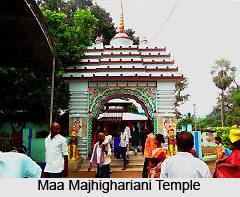
The temple of Maa Majhighariani, with significant religious interest is an important site of tourist interest in Rayagada. Only the face of the Maa Majhighariani is worshiped. During Sunday, Wednesday and Friday a large number of Devotees are coming to this place for worshiping the Goddess. However the tourism industry of Rayagada makes profit from this religious site during the festival of Chaitra-Parba i.e. March-April of every year.
Hatipahar shares a significant importance in the tourism industry of Rayagada, specially for its picturesque view. A place of great scenic beauty with two water falls on the course of river Nagavali, Hatipahar is an important spot for the picnic. One of the key interest about the place is that, the big boulders dotted over the pockets of Hatipahar, seems like big elephants. Hence the place is also named so.
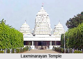
Famous temple housing Laxminarayana situated at IMFA Factory, Therubali. The temple at the same time is the abode of several other deities including Hanuman, Lord Jagannath, Balabhadra and Subhadra and Lord Siva. In the tourism industry it is mainly famous as an important religious center as a number of devotees flocked here throughout the year. Apart from these the architectural fabrications and carvings on the white marbles, with which the temple is made of is no less appealing to the tourists come to visit the temple.
The place Paikapada is famous for so many Siva Lingams. The car festival of Lord Jagannath celebrated during Sivaratri accumulates a large number of pilgrims to the core of Rayagada.
Apart from these there are other places, which are of considerable importance in the tourism industry of Rayagada, chiefly because of the extremely alluring landscape.
Important places of Rayagada
 In the heartland of Raygada one finds a bountiful of temples, picturesque locales, and buildings. To throw glance of these stunning locales multitudes of fervent tourists and visitors make visit to this city. Important places of Rayagada are as follows:
Hatipathar is famous for its picturesque locale with 2 waterfalls on the course of River.
Nagarvali. It lies at a distance of three kms from Rayagada. There are large boulders, which lie here and there.
On the confluence of three rivers, Minajhola is a charming spot and also a pilgrimage. It is the conflux of 3 three rivers. It lies at a distance of 134 kms only.
Maa Markama Temple - Maa Markama temple stretches to a distance of only forty kms from the city of Rayagada. The temple underwent a facelift, which is being surrounded by luxurious green forests. Tourists from far off places visit here with great enthusiasm.
Padmpur houses Manikeswar Shiva shrine. It has been recognized to be the seat of Dharmakirti. He was a Buddhist, logician and also a philosopher. It lies at a distance of 94 kms.
Chatikona is a landmark. It lies at a distance of only 48 kms from the city of Rayagada. It is the locale, which is encircled by numerous valleys, wooden mountains of varied colors.
The Mahadev temple is the famous pilgrimage center in Chatikona. The festival of Shiva Ratri is celebrated with great splendor and vivacity. Panoramic view of the waterfall is a special retreat for the visitors. Apart from these, one can also gain access to some important places of Rayagada like Laxminarayan Temple, Maa Majhighariani Temple, Devagiri.
Visiting Information
Rayagada District can be connected with railheads, roads and highways from different parts of India. Getting to Rayagada District is not difficult. Nearest airport is Visakhapatnam Airport, Andhra Pradesh, which is 200 kms away.
Transportation of Rayagada
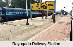 Good transportation of Rayagada enables the city to stay connected with all the other places of Indian continent. As a result Rayagada finds myriads of tourist and visitors paying visit to the place every year. In other words transportation of Rayagada acts as vital link of this city with the other regions of the country. All possible means like bus routes, railways have facilitated their service for the people. For example, one can avail frequent bus service from other places of Orissa like Berhampur, Koraput and Bhubaneswar.
Rayagada is a railhead on the Rajpur-Vizianagaram rail line, which is a part of South Eastern Railway. Train service also is accessible for Rayagada from Bhopal also.
Delhi, Chennai, Allepy, Bokaro, Raipur, Gujrat, Nagpur, Kolkata, Hyderbad, Bilaspur and Bhubaneswar etc are connected via railways.
Airport at Visakhapatnam, Andhra Pradesh lie in the vicinity. Lying about two hundred kilometers from Rayagada, it is well linked with other places of India. Flights for places like New Delhi, Kolkata, Chennai, Mumbai, Nagpur are available.
The famous NH-43 runs through Koraput. It is109 Kms from Rayagada itself. Direct express bus services can be obtained from places like Vizianagarm, Vishakhapatnam, Cuttack, Bhubaneswar, Puri, Jeypore, Malkangiri, Koraput, Phulbani, and many more.
Tribes of Rayagada District
 Rayagada district is an ideal abode for the tribal communities who have settled here peacefully. It had a total population of 832019, and amongst them, 473379 belong to tribal communities. With this fact in mind, all the eleven blocks of this particular district have been integrated into tribal sub-plan. Out of it, three micro projects operate for these native tribes of Rayagada who are illiterates.
Experts also have cited the reason for the huge concentration of theses tribal populace in Rayagada itself. Rayagada`s topography was such that the tribes of Rayagada could mention their age-old ethnicity and cultural identification. Rayagada constitutes of 4785.36 Sq.K.M. with 777.27 Sq.K.M remaining under reserved forest area. However, as a recent phenomenon, tribes of Rayagada along with their sub tribal communities witness development. Rate of development however, depends on the way they assimilate other contemporary communities.
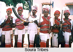
In the district, the kondhas and its subsection is the principal tribal community who comprises the maximum of the tribal population of the district. The second highest are the Souras. As far as education is concerned, both Kondhas and Souras tribes of Rayagada district have shown fewer propensities to education and learning. In spite of their accessibility to developmental process these two tribal communities, specially, have succeeded in retaining their tribal and ethnical identity to a great extent.
Apart from these two tribal communities, few more tribal communities reside. Although they are negligible in number these tribes of Rayagada rightly have made the culture of the district divergent and exotic.
The Kondhas are one of the ancient tribes who inhabit almost in all the blocks of the district. However they are hugely concentrated in various blocks of the district like Kashipur, Rayagada, Kalyansinghpur, Bissamcuttack and Muniguda. They fall into the racial group of Proto-Australoids and are known for their practice of sacrificing human beings during British era. For carrying conversation they converse in a distinctive language, known as "Kui". No written script is available. They are land dwellers and also rightly gel with the forest condition.
As has been mentioned earlier, Kondhas further can be divided into sub groups. Dongaria Kondha tribal community is the ancient most sub tribal group. They reside in the plateaus of Niyamgiri hill ranges, which encircle the areas of Rayagada and Koraput and Kalahandi districts. Huge concentration is found in Kalyansinghpur, Bissamcuttack and Muniguda blocks. They are known as Dongaria, which signifies dweller of "donger". In Oriya language dongar means hill. In the whole of the Orissa state of India they have been declared to be one of the thirteen primitive tribes.
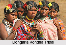 Two Dongaria Development Agencies (DKDAs) operated in 2 blocks for the overall growth of tribal communities. Their motive was to improve pre agricultural economy and low literacy scenario. For sustaining their livelihood, they have adapted to various occupations like foraging, hunting and gathering. Nowadays, they have developed dependence on shifting cultivation, also known as Podu or slash and burn cultivation.
Next in tandem is the Souras , also known as Lanjia Souras . They have developed the style of wearing a loin dress which hangs from behind and can be easily mistaken it for a tail. Because of their unique style of dressing they have been named so. They reside in various blocks like Padmapur Gunupur, and Gudari. They are mainly found in the Puttasingi area, which stretches up to a distance approximately 25 Kms from Gunupur NAC.
People identify them in various names like "Savara", "Sabara", "Sora". They belong to Proto Australoid group. Their main concentration is on Gunupur, which lies adjacent to several blocks like Gumma, Serango of Gajapati district. This tribal community has developed their own dialect. However, Soura tribes do not follow written language. Majority of people have taken up to shifting cultivation. Only a handful of people are practicing `settled agriculture`. They also practiced terraced cultivation. Crops like cereal and pulses are grown.
Tribal society also follows unique norms and practices. Family structure of these tribes of Rayagada is nuclear. However a handful of extended families known as Birinda also are predominant. Birinda comprises of all the successors of a common ascendant of 4 to 5 generations.
Their ritual of marriage also is quite significant. Three types of marriage are in vogue. These include marriage by elopement, bride capturing and also by negotiation. The last one is considered to be apt and ideal. It is quite expensive. Clan system is absent. Polygamy is prevalent. In a house, economy centers on the woman. She works very hard and also assists her husband in various works like plowing and reaping crops and also managing domestic activities.
Soura tribes of Rayagada are pious and practice religious practices, which are very intricate and deep-seated. Polytheism is dominant. They have developed beliefs in a myriad of deities and hereditary spirits.
Their artistic acumen is far-famed for wall paintings. These paintings are called Edital. Dance and music is an integral part of the lives of these tribes of Rayagada. Out of fear of being afflicted by any kind of personal harms and threats, these tribes of Rayagada follow certain laws, rituals and thus appease the deities.
Soura tribes of Rayagada fete quite a number of festivals. There are wide ranging starting from family occasions like those related to birth and girls attaining puberty. Several harvesting festivals are held in celebration of good sowing. Whole of the community gets involved into the celebration of these festivals. There is a unique feature of these festivals. Those are the days when these Soura tribes consume alcohols like Mahua and Handia. The mood gets frenzied with dancing and singing continuing through out the night. Animal also is sacrificed for pleasing the deities especially the harmful ones.
The way the political institutions of Soura tribes of Rayagada are formed too is significant. In each and every village and region, a conventional political association is formed with few hereditary posts. For instance, Gomango is the secular headman. The person who used to lead the religion is called Buyya. Other people like Mondal , Barik and Raito are the messengers who perform various functions of a traditional court of law.
They first listen to both sides and then impart punishments accordingly.
Education in Rayagada
Education in Rayagada city has been given much priority by all the residents of the city. A number of schools, colleges have developed catering their demands and needs. GCD high school is the ancient most school and is quite popular amongst the people. Sacred Heart School is another one. It imparts education in the medium of English language and also has developed affiliation to ICSE, Delhi. New Life English Medium School is also significant.
Colleges also are integrated in the system of education in Rayagada. These are ideal for those who want to pursue education to a higher level. One such important institution is Rayagada College transmitting education at +2 and +3 levels. Pupils of various streams like science, arts and commerce enroll their names for furthering their studies. There is a separate college for women, which highlights that their education is also not neglected a bit. It offers +2 level education for science, arts and commerce students. However at +3 level education for arts stream only has been imparted.
Few engineering colleges too have developed so that the technical education in Rayagada is not neglected. UTKAL GOURAB MADHUSUDAN INSTITUTE OF TECHNOLOGY(UGMIT) is the name of an engineering college which offers diploma courses in numerous branches of engineering. The state government ran it. It is located in the wonderful locale with river NAGABALI flowing in the vicinity. Besides a couple of engineering colleges have been built which impart courses like MCA, B.Tech, MBA and Biotechnology. IACR is another reputed technical college of the city, which provides degree of B Tech, MCA, MBA. It has got a wonderful locality. It stretches to a distance of near about 2 kms from the main road. Another significant college is Majhigharaini Institute of Technology and Sciences (MITS), which is located almost 8 kms from the city. In Rayagada, Institute of Advanced Computer & Research, Rayagada is an institution of excellence. It is approved by All India Council for Technical Education (AICTE) and also got affiliation from the reputed Biju Patnaik University of Technology, Bhubaneswar and Berhampur University, Berhampur.


